Area counties: Sac-Crawford-Carroll-Audubon-Guthrie-Dallas-Cass-Adair-Madison-Adams-Union-Taylor-Ringgold–
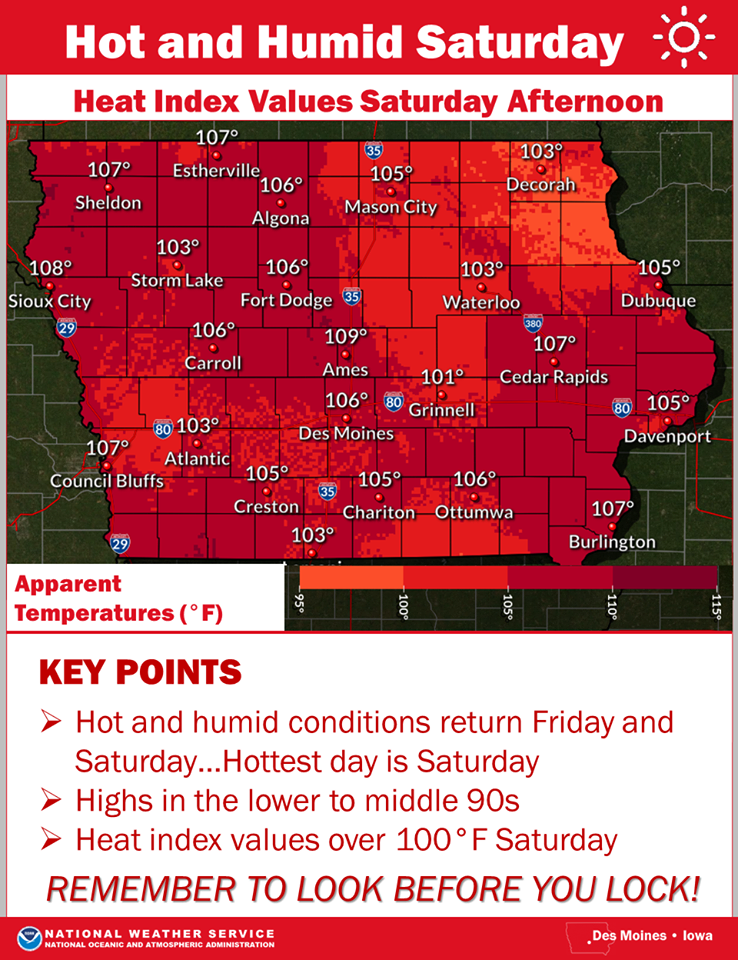
Warm-humid air will continue to push into western and central Iowa this afternoon. Air temperatures are forecast to reach the lower 90s, with dewpoint temperatures in the low to mid 70s. This combination will result in heat index values in excess of 100 degrees, with a few localized spots possibly reaching 105 degrees for a brief period this afternoon. Warmest conditions will occur between 1-4 P.M. Limit outdoor activities if possible today. If you must be outside, take frequent breaks, and remain properly hydrated.
(Radio Iowa) — Iowa farmers will want to take note as what’s being called a La Nina Watch is being issued by the Climate Prediction Center, which forecasts a possible cooling in the Pacific Ocean’s surface over the next six months. Doug Kluck, the regional climate service director for the National Weather Service in Kansas City, says the long-range development is far from certain, but they’re watching carefully. “Right now, it looks weak, if it’s going to happen at all,” Kluck says. “It’s not a very good chance. There’s not a lot of confidence it’s going to happen yet. As we get closer and closer to fall, that confidence will hopefully go up in terms of what’s actually going to happen.”
Kluck says a La Nina pattern can have impacts all across the country, sometimes bringing significant changes in weather patterns and dramatic shifts for agriculture. “Temperatures in the southern part of the U.S. tend to be above normal,” Kluck says, “and temperatures as you move north are closer to normal or even below-normal as you get a stronger and stronger La Nina event.” Kluck says Iowa and the rest of the Northern Plains region could see more rain and snow under a La Nina. “And with precipitation, it’s kind of a similar game here,” Kluck says. “Drier to the south and wetter to the north, especially in the north-central part of the U.S. again, if the La Nina signature occurs in the Pacific.”
Kluck says observers will have a better idea of the strength of the possible La Nina by late fall into early winter.
(Radio Iowa) – Information from air quality monitors showed several cases where the air quality exceeded the E-P-A limit for fine particles in the air during the Fourth of July weekend. The D-N-R’s Todd Russell says the state generally does not have such long-term periods where the air exceeds the federal standard. Russell says there was one in Davenport in 2012. “That one was pretty significant. I believe we have had maybe a couple of other exceedances at one or two sites over the last several years. But this was by far the largest and most extensive as far as area wise as well as the intensity or the levels,” Russell says.
He says air monitors saw issues in Des Moines, Davenport, and Muscatine on July 4th, and in Des Moines and Clive on July 5th. Russell says they don’t know for sure — but the problems were most likely created by people shooting off fireworks — NOT professional fireworks shows. He says that was particularly the case in the Des Moines area. “Just observations and what folks all around town saw. The smoke hanging at low levels and the spread of the smoke pretty much all over the city,” according to Russell. “I would guess it was much more local personal fireworks. But that is somewhat a guess on my part.”
Russell says the calm weather conditions likely contributed to the problem. “The smoke did not tend to rise as it normally would in normal conditions. The calm winds and the atmospheric inversion — or a capping layer over our ground-level air — held all that smoke, both down close to the ground, and allowed it to just spread out rather than being blow away in one direction or another.” He says the air in Iowa this summer has otherwise been clean. Russel says less traffic on the roadways and businesses shut down by the pandemic may be contributing to cleaner air.
“Possibly our air quality has been better due to the decrease in economic activity. I would say that is more true possibly for ozone than particulate. It is not something that we can quantify,” Russel says. Ozone is created by cars and trucks on the roadways.
Pottawattamie-Mills-Montgomery-Fremont-Page

...EXCESSIVE HEAT WARNING IN EFFECT FROM 1 PM THIS AFTERNOON TO
8 PM CDT THIS EVENING...

* WHAT...Dangerously hot and humid conditions with heat index
  values up to 115.

* WHERE...Portions of east central, northeast and southeast
  Nebraska and southwest Iowa, including the Omaha, Council Bluffs
  and Lincoln Metro areas.

* WHEN...From 1 PM this afternoon to 8 PM CDT this evening.

* IMPACTS...Extreme heat and humidity will significantly
  increase the potential for heat related illnesses,
  particularly for those working or participating in outdoor
  activities.

PRECAUTIONARY/PREPAREDNESS ACTIONS...

Drink plenty of fluids, stay in an air-conditioned room, stay out
of the sun, and check up on relatives and neighbors. Young
children and pets should never be left unattended in vehicles
under any circumstances.

Take extra precautions if you work or spend time outside. When
possible reschedule strenuous activities to early morning or
evening. Know the signs and symptoms of heat exhaustion and heat
stroke. Wear lightweight and loose fitting clothing when
possible. To reduce risk during outdoor work, the Occupational
Safety and Health Administration recommends scheduling frequent
rest breaks in shaded or air conditioned environments. Anyone
overcome by heat should be moved to a cool and shaded location.
Heat stroke is an emergency! Call 9 1 1.
THE NATIONAL WEATHER SERVICE HAS ISSUED HEAT ADVISORY IN EFFECT FROM 1 PM TO 8 PM SATURDAY FOR NEARLY ALL OF IOWA.
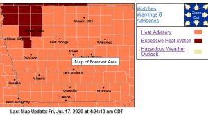 Heat index values 105 to 110 degrees can expected.Hot temperatures and high humidity may cause heat illnesses to occur, particularly those working or participating outdoor activities.
PRECAUTIONARY/PREPAREDNESS ACTIONS…
Drink plenty of fluids, stay in an air-conditioned room, stay out of the sun, and check up on relatives and neighbors. Young children and pets should never be left unattended in vehicles
under any circumstances.
Take extra precautions if you work or spend time outside. When possible reschedule strenuous activities to early morning or evening. Know the signs and symptoms of heat exhaustion and heat stroke. Wear lightweight and loose fitting clothing when possible. To reduce risk during outdoor work, the Occupational Safety and Health Administration recommends scheduling frequent rest breaks in shaded or air conditioned environments. Anyone overcome by heat should be moved to a cool and shaded location. Heat stroke is an emergency! Call 9 1 1.
What little rain that fell overnight Wednesday into Wednesday morning, did little to help the crops and soil they live in. The latest edition of the Iowa Drought Monitor released today (Thursday, shows parts of Cass, Adair, Audubon, Dallas and Guthrie Counties, are in a Severe Drought. Other area counties affected by the severe drought include Boone, Carroll, and Greene, along with the northwest corner of Madison County. Other area counties are in a “Moderate Drought,” which is characterized by: Soybeans aborting pods; Struggling corn test weights; Grasses are brown & more grass fires occur; The possible issuance of bans; and pond levels decline.
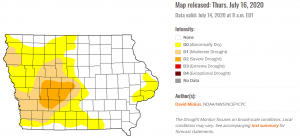 Officials say a continued severe drought could potentially result in: extremely low corn yields; A high fire danger; fewer mosquitoes observed; low surface water, increased algae blooms, and a requested voluntary effort at water conservation.
For more information: https://droughtmonitor.unl.edu/CurrentMap/StateDroughtMonitor.aspx?IA
The National Weather Service in Des Moines says hot and humid conditions will return Friday and Saturday. The hottest day is forecast to be on Saturday when high temperatures will rise into the middle 90s and heat index values of 101 to 109°F are anticipated by the afternoon hours! Still sticky on Sunday, but temperatures will range around 90°F for highs and there will be storm chances late in the evening into Monday morning.