
(Radio Iowa/KJAN) – With low temperatures this (Monday) morning in the 40s and 50s across Iowa, it’s becoming clear that August could contain a radical shift from the extreme heat of July. State climatologist Justin Glisan says July wrapped up on Friday being much warmer and drier than normal. “Typically, we expect the temperature to be around 74 degrees, the average temperature for the state, and it’s looking like anywhere from two to three degrees above average, depending on where you are in the state,” Glisan says. “In terms of precipitation, the story of the month is drought conditions creeping into western Iowa.”
The month of July in Atlantic was warmer and drier than usual. Data for the month compiled at the KJAN Studios show Atlantic’s High for July was 88 degrees, or about 2 degrees warmer than normal. The average Low was nearly spot-on, 63. But the average rainfall, well, the bucket was very shallow last month. Normally we see around 4.62 inches. Last month, was only received 1.22 inches here at KJAN. During the month of August, Atlantic will typically see 3.88 inches of rain (but we know this year has been anything but “typical”). Our average High is normally 83 and the average Low is 72.
The latest surveys show more than half of Iowa is either in drought already or has very dry conditions, with the worst areas being in western Iowa and moving eastward. “Typically, we expect four-and-a-half inches of rainfall across the state and there are parts of the state that only received 25% of what they normally would get in July,” Glisan says. “There are pockets in west-central Iowa that are anywhere from three to four inches below average.” Coming out of the hotter, drier July, Glisan says August promises to be a cooler, wetter month. “That would be an absolute gift for our drought region. We have 22 counties that are currently in D-2 drought, which is severe drought,” Glisan says. “Cooler temperatures and more rainfall would help mitigate any kind of crop stress that we’re seeing out there but it would also help improve the drought conditions that we’re seeing.”
High temperatures for the week ahead are expected to be in the 70s and low 80s with mostly dry conditions in the forecast.
The Shelby County Emergency Management Agency reports the Tornado Siren warning system will be tested today, across Shelby County. The test begins at 12:30-p.m. No severe weather is expected today. Again, the Tornado Warning sirens will sound at 12:30-p.m., across Shelby County.
Well, if you hadn’t figured it out, the month of July in Atlantic was warmer and drier than usual. Data for the month compiled at the KJAN Studios show Atlantic’s High for July was 88 degrees, or about 2 degrees warmer than normal. The average Low was nearly spot-on, 63. But the average rainfall, well, the bucket was very shallow last month. Normally we see around 4.62 inches. Last month, was only received 1.22 inches here at KJAN.
During the month of August, Atlantic will typically see 3.88 inches of rain (but we know this year has been anything but “typical”). Our average High is normally 83 and the average Low is 72.
Today: Partly sunny, with a high near 77. North wind 6 to 14 mph, with gusts as high as 20 mph.
Tonight: Mostly clear, with a low around 52. North wind 5 to 11 mph.
Monday: Sunny, with a high near 72. North northeast wind 6 to 13 mph.
Monday Night: Mostly clear, with a low around 49. Northeast wind 5 to 7 mph becoming calm in the evening.
Tuesday: Sunny, with a high near 76. Calm wind becoming east around 5 mph.
Tuesday Night: Partly cloudy, with a low around 53.
Wednesday: Partly sunny, with a high near 78.
Saturday’s High in Atlantic was 84. We received .59″ rain at the KJAN Studios. Our Low was 54. Last year on this date the High in Atlantic was 83 and Low 60. The Record High on this date was 103 in 1930, and the Record Low was 42 in 1907.
(Radio Iowa) – The new report from the U-S Drought Monitor shows more counties now showing dry conditions. The Iowa D-N-R’s Tim Hall says the negative outweighs the positive in the report. “We had a little bit of improvement in one part of the state — but mostly we had degradation or increasing drought in other parts of the state,” Hall says. He says the driest area continues to be in western Iowa. “It’s centered around Carroll, Greene, Guthrie and Audubon County and then in the partial counties around there,” Hall says. “Kind of that part of the state, there’s a little bit of D-two drought in Plymouth County up in northwest Iowa. So, those two areas together are the worst parts.”
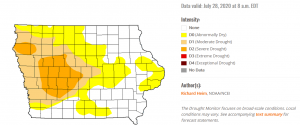 Hall says the dry conditions have started to spread to the east. “Now there’s exceptional dryness as far east as Linn County, and then also along the river,” according to Hall. “So we’ve got about half the state, a little over half the state is shown in some form of dryness and drought.” Hall says the impact of the dry areas can also be seen in satellite images of the crops. “There’s a tool out there called VegDRI — which also comes from the drought monitor folks — and they’re actually looking at visual indications of stress in vegetation. And that VegDRI map lines up pretty closely with where we’ve seen the precipitation deficits,” Hall says.
He says the good news for the western areas that are dry is the impact right now isn’t hitting water supplies.”I think because of the exceptionally wet couple of years we had coming into this year we’re still doing okay on the groundwater side. Right now it’s primarily an agricultural surface water phenomenon,” he says. Hall says the precipitation deficit is a concern because we are soon going to be heading out of the wettest months of the year, and could be behind in groundwater going into the winter.
Today and tonight: Hot and humid conditions are expected to persist today, mainly across the southern half of the state with highest heat index values of 100 to 105.
Thunderstorms are also expected today into tonight, moving generally from north to south across the state. There is a marginal risk of severe thunderstorms across much of central Iowa with the main concern from strong to damaging thunderstorm winds. Locally heavy rainfall is also possible.
Monday through Saturday: Some isolated thunderstorms are expected late in the work week across Iowa. The severe threat appears low at this time.
The National Weather Service has issued a HEAT ADVISORY IN EFFECT FROM NOON TODAY TO 8 PM CDT THIS EVENING for the entire State of Iowa. Expect a heat index of up to 105 degrees.
* IMPACTS…Hot temperatures and high humidity may cause heat illnesses such as heat exhaustion or heat stroke to occur.
PRECAUTIONARY/PREPAREDNESS ACTIONS…
Drink plenty of fluids, stay in an air-conditioned room, stay out of the sun, and check up on relatives and neighbors. Young children and pets should never be left unattended in vehicles under any circumstances.
(Radio Iowa) – A new map from the National Drought Mitigation Center shows dry conditions worsening in western and central Iowa. State climatologist Justin Glisan says 15 counties are now in what’s considered severe drought. “Over the last 30 to 45 days, we’ve seen a dwindling rainfall, especially across west-central Iowa,” Glisan says. “If we go back four to six months, we actually see precipitation deficits in the range of eight to 12 inches, so we’ve been dry, especially across western Iowa.”
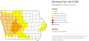 Glisan says he’s constantly asked about when and if any significant rainfall is coming to Iowa. “The forecast models just have been off for some reason,” Glisan says. “When we expect rain out of Nebraska, it comes toward western Iowa and you can watch it on radar, it just sort of vanishes. Because of those dry conditions, there’s not enough moisture at the surface to really pop those storms up.” Glisan says he remains hopeful the situation may change soon.”If we look at our outlooks moving into next week, it looks like we’re starting to turn down the temperature dial,” he says, “and along with that, we’re trending towards near-normal rainfall moving into the first of August.”
A very hot weekend is ahead but the forecast calls for the chance of rain Sunday night, moving into Monday. Severe drought is shown in part or all of these 15 counties: Adair, Audubon, Boone, Calhoun, Carroll, Cass, Dallas, Greene, Guthrie, Madison, Polk, Sac, Shelby, Story and Webster.
(Radio Iowa) – Another sweltering July weekend is in the forecast, as high temperatures tomorrow (Saturday) across Iowa are expected to climb into the low- to mid-90s with heat indices returning to the triple digits. Mark Mintun, an emergency medical staffer at Van Diest Medical Center in Webster City, says if you’re planning on being active and outside, you must push fluids “It’s all about hydration,” Mintun says. “You should start in the morning when it’s still cool out. You should be drinking water, sports drinks, Pedialyte, whatever you like the best or think works the best. If you work outside, you really have to be proactive and start drinking early in the morning and drink every time you think of it.”
 Without taking precautions and staying well hydrated in this heat, Mintun says you could be facing a very unpleasant road. “Heat exhaustion, you’ll get kind of dizzy, you’ll sweat a ton, your skin will feel cool and clammy even though your body is hot,” Mintun says. “Your heart will be going fast and you’ll start to get some muscle cramps. Heat stroke, things get a lot worse. You’ll get a severe headache, you don’t sweat any more, again a fast heart rate and you’ll feel very faint. You may even pass out.”
If you don’t pay attention to the warning signs, Mintun says your condition can quickly go from bad to worse. “Heat exhaustion can transition very rapidly to heat stroke,” Mintun says. “Once you start getting cramps and sweating bad and just feeling overall horrible, you have to get to a cool area, you have to hydrate. If that’s not working, you’re probably going to have to seek emergency medical attention.” Other tips for beating the heat include: wear plenty of sunscreen, wear light-colored, light-weight clothing — and a hat — and take frequent breaks in the shade or indoors. Keep up with the latest forecast at weather-dot-gov.


