
The Severe Storms Prediction Center in Norman, Oklahoma, today (Tuesday), issued a summary of the storms that passed through the Midwest, Monday. An intense derecho (pronounced “Deh’RAY-show”) moved from far southeast South Dakota into Ohio yesterday (8/10/20). This derecho traveled approximately 770 miles in 14 hours and produced widespread damaging wind gusts, including numerous wind gusts over 74 mph (65 kt) & several over 90 mph in central Iowa. 
(Radio Iowa) – The Derecho (a long-lasting, straight-line wind storm) that plowed through Iowa yesterday (Monday) caused significant damage in the Marshalltown area, a part of the state still recovering from the 2018 E-F-three tornado. A 99 mile-per-hour gust was reported at the Marshalltown Airport as the winds and rain inundated the community, damaging not only buildings and houses and trees in downtown Marshalltown, but throughout the community and beyond. But like two years ago, Marshalltown Police Chief Mike Tupper says when it came to people, no lives were lost.
“We got through another one without any significant or minimal significant injuries,” he says. “I know that we had one person injured during the storm fairly seriously.” Two years ago, the historic Marshall County Courthouse took a direct blow from the tornado. Renovation is work has been ongoing, with workers on scaffolding to repair the courthouse exterior. County Auditor Nan Benson says all the workers made it to shelter in time.
“We were able to get all the workers off of the scaffolding around the courthouse. Surprisingly, it’s like we knew it was coming, but I don’t know if our construction folks were not paying attention to the weather, but luckily everyone was off the scaffolding, so there were no injuries there. There was pieces of scaffolding flying around during the storm.” Marshalltown Aviation General Manager Steve Valbrecht says damage was minimal at the airport, despite that 99 mile an hour wind gust.
“We did have some damage to the buildings out here, as you can expect (with) metal buildings — roofing and collapsed hangar doors,” he says. “And one hangar door that actually left the hangar. There wasn’t any damage to any airplanes that we can find yet.” As of Monday night, the promise of power returning to Marshalltown, as well as Ames and other central Iowa communities was not known, but for some areas it could be days.
(Radio Iowa) — State Climatologist Justin Glisan is among those dealing with damage from Monday’s severe weather. Glisan and his wife were working from home when the storm rolled through the Beaverdale neighborhood in Des Moines. “We call it a Derecho. It’s literally a wall of wind,” Glisan says. “This is the most frightened I’ve been in my life.” The wind blew a neighbor’s huge maple tree into Glisan’s house, sheared off the gas main and pushed into the foundation.
“We had a gas leak downstairs, so we had to leave,” Glisan says, “get out of the house with our dog, George, and get into a car and we drove to a parking lot that was free of large trees and just had to wait it out because we didn’t have anywhere else to go.” The first storm warnings were issued yesterday (Monday) morning for western Iowa, with wind speeds reported between 60 and 70 miles an hour. The winds picked up speed as they moved through the state, with a 99 mile per hour gust recorded in the Marshalltown area.
“Once you get a squall line like this to stay together, it just perpetuates itself,” Glisan says, “and that’s what happened.” Glisan says yesterday’s (Monday’s) storm is a reminder to heed National Weather Service warnings. “These events can get severe really fast and it can impact life and property, as we’ve seen across much of Iowa,” Glisan says.
Many communities in the path of the storm asked residents to stay home, as crews removed storm debris and power lines from streets and roads. By mid-afternoon Monday, more than 420-thousand Iowa homes and businesses had lost power according to the National Weather Service.
IOWA CITY, Iowa (AP) — A rare wind storm with power similar to an inland hurricane swept across the Midwest, blowing over trees, flipping vehicles, causing widespread property damage and leaving tens of thousands of homes without power. The storm known as a derecho lasted several hours as it tore across eastern Nebraska, Iowa and parts of Wisconsin and Illinois.

Pieces of the Buccaneer Arena roof litter the parking lot after a strong thunderstorm with high winds blew through the Des Moines metro on Monday, Aug. 10. 2020, in Urbandale, Iowa. (Kelsey Kremer/The Des Moines Register via AP)
A scientist at the National Weather Service’s Storm Prediction Center says the storm had the wind speed of a major hurricane, and likely caused more widespread damage than a normal tornado. Officials in the Iowa cities of Des Moines, Cedar Rapids and Marshalltown say the damage is extensive.
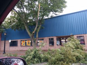
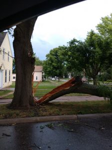
Winds gusting anywhere from 50-to 75 mph thundered through western and west central Iowa this morning, including here in Cass County. Numerous tree limbs, small and large were snapped and littered the downtown corridor in Atlantic, as well as many side streets and intersections. Cass County Emergency Management Coordinator Mike Kennon said the story was pretty much the same in Marne. As of 10:45-a.m., there was no report of injuries or significant property damage in the County.
A tree limb fell on a house near Adel at around 10:30-a.m. A large tree limb fell on a car in Denison. A semi jackknifed in the Crawford County community of Kiron. Significant tree damage was reported in Guthrie Center, Carroll, Templeton and many other locations as well. Some sites reported pea size hail. Power outages were common, as crews struggled to reconnect downed lines in the area. (Ric Hanson/photos)
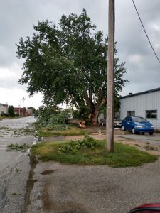

10:00-a.m. Tree limb fell on a power line behind Walnut Hill Terrace Apts. in Atlantic, tree on fire; 10:02-a.m. – Power line down by Brown Auto Body in Atlantic. (Public report/Comm. Ctr.)
10:10-a.m. Large tree branch in the road between 4th and 5th Street in Atlantic, on Locust. (Public report)
9:36-a.m. Thunderstorm wind damage – Carroll County – large tree limb (6″ wide, 20-feet long) down. Several smaller limbs down as well. (Spotter report)
9:35-a.m. 64 mph wind gust at the Harlan Airport (AWOS)
9:33-a.m. 60 mph wind gust 3 miles east of Harlan (MESONET)
SEVERE THUNDERSTORM WATCH OUTLINE UPDATE FOR WS 425
NWS STORM PREDICTION CENTER NORMAN OK
855 AM CDT MON AUG 10 2020

SEVERE THUNDERSTORM WATCH 425 IS IN EFFECT UNTIL 200 PM CDT
FOR THE FOLLOWING LOCATIONS
.    IOWA COUNTIES INCLUDED ARE

ADAIR                AUDUBON             BLACK HAWK
BOONE                BREMER              BUTLER
CALHOUN              CARROLL             CASS
CLARKE               CRAWFORD            DALLAS
FRANKLIN             GREENE              GRUNDY
GUTHRIE              HAMILTON            HARDIN
HUMBOLDT             JASPER              LUCAS
MADISON              MAHASKA             MARION
MARSHALL             MONROE              POCAHONTAS
POLK                 POWESHIEK           SAC
STORY                TAMA                WAPELLO
WARREN               WEBSTER             WRIGHT
The Severe Storms Prediction Center in Norman, OK., has placed most of Iowa under risk for severe storms today. Atlantic, Carroll, Creston and Council Bluffs, have a slight risk of severe weather. Eastern Iowa (Dubuque, Waterloo, Cedar Rapids, Davenport and Burlington) are under a moderate risk. The greatest threat appears to be strong winds and hail for our area, and a slight risk for tornadoes in eastern Iowa. Stay tuned to KJAN for any severe weather developments. There are currently NO watches or warnings in effect for the immediate listening area, but a Severe Thunderstorm Watch is in effect until 11-a.m. today for northwest Iowa, including Monona County.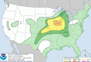
Mills-Fremont-Page Counties: .HEAT ADVISORY IN EFFECT FROM NOON TODAY UNTIL 8 PM.
Heat index values of 104 to 107 can be expected. Hot temperatures and high humidity may cause heat
illnesses to occur.
PRECAUTIONARY/PREPAREDNESS ACTIONS…
Drink plenty of fluids, stay in an air-conditioned room, stay out of the sun, and check up on relatives and neighbors. Young children and pets should never be left unattended in vehicles under any circumstances.
Take extra precautions if you work or spend time outside. When possible reschedule strenuous activities to early morning or evening. Know the signs and symptoms of heat exhaustion and heat stroke. Wear lightweight and loose fitting clothing when possible.
To reduce risk during outdoor work, the Occupational
Safety and Health Administration recommends scheduling frequent rest breaks in shaded or air conditioned environments. Anyone overcome by heat should be moved to a cool and shaded location.
Heat stroke is an emergency! Call 9 1 1.
The latest State of Iowa Drought Monitor information shows parts of nine area counties are in an Extreme Drought, while parts of several adjacent counties are in a severe-to-moderate drought. 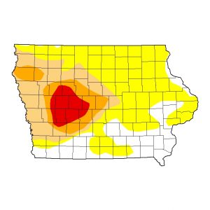 The dry conditions cover nearly two-thirds of the State, with eastern Iowa the least affected, with what is being called “Abnormally dry” conditions. Counties in an Extreme Drought include all of Audubon and Carroll Counties, 90% of Greene and Guthrie Counties, and about one-third of Cass, Dallas, Shelby and Crawford Counties. Portions of Calhoun, Sac and Boone Counties are also impacted by an Extreme Drought.
In Counties affected by an Extreme Drought:
(More info. at https://droughtmonitor.unl.edu/CurrentMap/StateDroughtMonitor.aspx?IA)


