
It’s no surprise the Month of August was exceptionally dry here in southwest Iowa. The data for Atlantic shows we received 3.01 inches less rain than average. The clouds managed to squeeze out a total of just .87″ for the month. We were also a little warmer. The Average High for August is typically 83. Last month, our Average was 87, with the hottest days coming the last week of the month. The Average Low was 58, which is 14 degrees cooler than normal.
During the month of September, Atlantic normally sees about 3.81 inches of rain. The average High is 76 and the average Low is 51.
Data chart provided by Aaron Saeugling, ISU Field Agronomist, based in Lewis.
(Radio Iowa) – Drought conditions continue to expand in Iowa, covering nearly 88 percent of the state. State Climatologist Justin Glisan says rainfall in western Iowa over the last six months is as much as a foot below normal — and in Iowa’s extreme drought region last week’s derecho dropped between a half inch to an inch of rain. “For a drought buster to take really hold you would need measurable rainfall every five-to-seven days for a few months to really start eating into those precipitation deficits,” Glisan says.
 The latest drought report was issued yesterday (Thursday). It classifies new areas of southern Iowa as abnormally dry and parts of northeast Iowa as moderately dry. Extreme drought conditions are reported in all or part of a dozen west central counties, including the cities of Carroll, Jefferson and Audubon. “It’s not looking like we’re going to get measurable rainfall that we need over the next seven days,” Glisan says.
Glisan says there may be more chances for rain as summer ends and storms tend to produce up to an inch of gentle rainfall over several hours. Until then, Glisan says weather systems over Minnesota and Missouri could shift and produce rain over Iowa and hurricane season could have an impact. “The tropics are starting to heat up again. There’s a possibility of two landfalls in the Gulf of Mexico,” he says. “If those tropical systems do make inroads into the United States, we might be able to seed some moisture into the Midwest, making conditions more favorable for rainfall.”
The U.S. Drought Monitor indicates areas of southwest and southeast Iowa are NOT in the drought zone.
(Radio Iowa) – As experts survey storm damage, estimates on wind speeds from last week’s destructive derecho continue to climb — and are now well into record territory. Rich Kinney is the warning coordination meteorologist at the National Weather Service in the Quad Cities and he’s inspected the devastation himself in communities across eastern Iowa. “The maximum estimated winds at this point are around 140 miles an hour,” Kinney says, “and that’s associated with structural damage in the Cedar Rapids area.”
Wind speeds for a major, Category Four hurricane range from 130 to 156 miles an hour — lending credence to those who’ve called this powerful storm a “prairie hurricane.” Kinney, who’s been with the weather service 23 years, says he’s never seen this type of destruction before, especially in Iowa. Cedar Rapids got the worst of it, he says. “Some apartment complexes where the entire roof was lifted off,” Kinney says. “Most of the exterior walls on the top floor were gone and a few of the interior walls as well.”
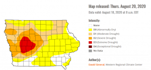
KROS radio tower blown down by the derecho.
The highest estimated winds in this storm were gusts of 126 miles an hour, recorded at a home weather station of an emergency manager in the Benton County town of Atkins. The estimated winds of 140 miles an hour that were based on the structural damage -could- be an all-time Iowa record for straight-line winds. Might they go even higher? “That is hard to say,” Kinney says, “because we’re still getting additional reports coming in daily, even ten days after the incident.”
Gusts between 120 and 140 miles an hour are now estimated in three main areas of eastern Iowa: a long stretch across Linn County which includes Cedar Rapids, and smaller patches in and around the city of Clinton and straddling both Jones and Cedar counties. With state damage estimates approaching four-billion dollars, Kinney says this will likely go down as the most powerful derecho Iowa’s ever seen, especially given the long-duration winds. “For a lot of folks, that’s what really made it seem like you were experiencing a hurricane,” Kinney says. “We had many locations with sustained, strong winds and extreme gusts for 30 to 45 minutes or so.”
A radio antenna near Van Horne that was rated to be able to withstand 125 mile per hour winds was snapped off in the storm. Another radio tower in Clinton, carrying the signal of Radio Iowa affiliate K-R-O-S, was flattened in winds Kinney estimates at 130 miles an hour.
Today: Mostly sunny w/just a slight chance of showers and thunderstorms after 5pm. High near 86. Light south southwest wind becoming west southwest at 5 to 10 mph.** A few storms may approach
severe limits with strong winds the primary threat.**
Tonight: Partly cloudy w/a 30% chance of showers and thunderstorms, mainly before 8pm. Low around 60. New precipitation amounts of less than a tenth of an inch, except higher amounts possible in thunderstorms.
Monday: Sunny, with a high near 84. N/NE winds at 5 to 10 mph in the morning.
Monday Night: Mostly clear, with a low around 58.
Tuesday: Mostly sunny, with a high near 85. S @ 5-10.
Tuesday Night: Partly cloudy, with a low around 60.
Wednesday: Mostly sunny, with a high near 85.
Saturday’s High in Atlantic was 87. Our Low was 56. Last year on this date the High in Atlantic was 82 and Low 63. The Record High on this date was 105 in 1936, and the Record Low was 48 in 1966.
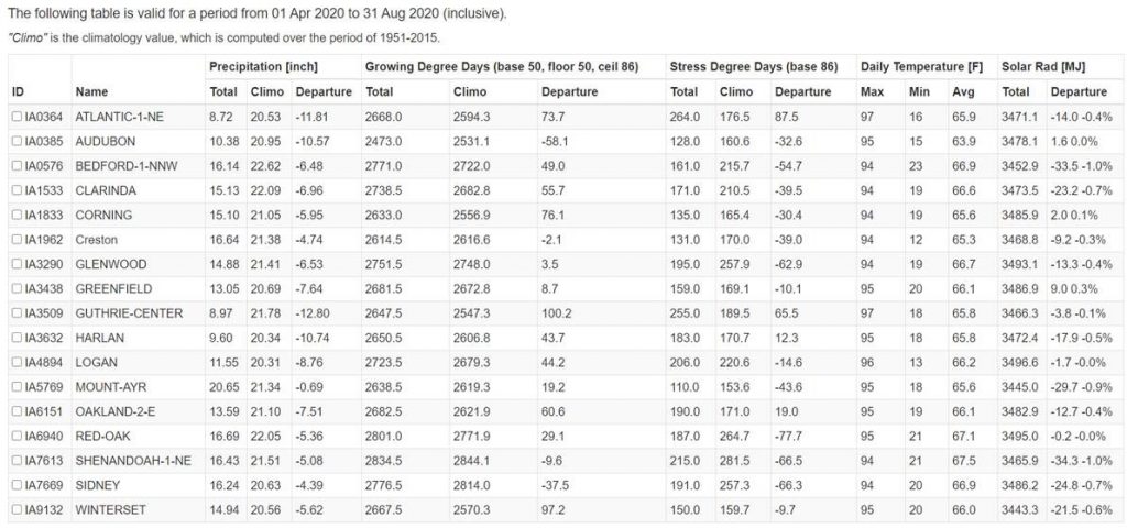
(Radio Iowa) – Even with all of the rain that fell on Iowa during Monday’s derecho, the latest report from the U-S Drought Monitor shows little change from a week ago. The report shows all or parts of 11 counties in west-central Iowa are in their second week in the D-3 category, which means extreme drought. The scale only goes up to D-4, which is exceptional drought, though none of Iowa has reached that level yet this year.
The report shows much of Iowa’s western half remains under moderate or severe drought, while much of northern and east-central Iowa is considered abnormally dry. Only a smattering of counties on the southern and eastern borders are in normal territory.
The 11 counties now shown in extreme drought are: Adair, Audubon, Boone, Calhoun, Carroll, Cass, Crawford, Dallas, Guthrie, Sac and Shelby.
(Radio Iowa) – A quarter of a million Iowa homes and business are still without power this (Thursday) morning. Ames residents have been warned damage is so dense and significant, power may be out for a week in some areas. Governor Kim Reynolds toured Marshalltown Wednesday afternoon and told reporters the damage she saw may be worse than the devastating tornado that hit Marshalltown two years ago. “Just from a mental perspective of trying to deal with all of that, it’s just tough,” Reynolds says. “They’re hit pretty hard again.”
The governor has gotten an aerial view of crop damage this week and she visited a grain elevator that was critically damaged. With silos and bins smashed in areas that were hit Monday, Reynolds says storage for this year’s crop will be a significant issue. “There’s no way that they’re going to be able to rebuild the bins this fall — materials, construction — I mean, just across the board it’s not going to happen,” she says.
Iowa Agriculture Secretary Mike Naig says farmers may have to resort to open-air storage — piling the grain on the ground.
(Radio Iowa) – Weather experts are analyzing a wealth of data about Monday’s powerful storm that carved a destructive path across Iowa’s midsection, wiping out trees, power lines and crops. Most of us now know the term “derecho,” a fast-moving, severe wind event, but State Climatologist Justin Glisan says it’s a fairly common type of storm.
“Typically the state of Iowa will see a derecho at least once every two years,” Glisan says. “Recent notable derecho events were July 11, 2011 and June 24, 2013.” To be designated as a derecho, a storm must have a width of at least 60 miles and travel at least 400 miles. Monday’s derecho started in southern South Dakota.
“The derecho itself held together for 770 miles over 14 hours before losing strength as it entered western Ohio,” Glisan says. Dennis Todey, director of the U-S-D-A’s Midwest Climate Hub in Ames, says derechos are hard to predict. “Unfortunately, we can’t forecast these things too well in advance,” Todey says, “but once it set up and it was starting to look consistent, the Weather Service was right on top of it then and was doing warnings well ahead of it, letting people know this was a pretty nasty situation and had the potential for doing severe damage, which it did.”
More than a half-million Iowa homes and businesses lost power during the storm, easily among the worst weather disasters for the state’s electric utilities. The governor has declared 20 counties disaster areas. Todey says they had eyes on the storm early on, but no one realized how strong it would become, or how quickly it would strengthen. “It went about 700 miles, kicked up right over South Dakota,” Todey says. “It didn’t seem like there was too much there, but it hit the Missouri River and western Iowa is where it really started causing damage. Part way into Iowa is where it really cranked up. The central part of Iowa is where the worst damage started.”
Winds ranged in most areas of Iowa from 70 to 90 miles an hour, though there’s a report of peak gusts of 112 miles an hour near Cedar Rapids. That’s the nature of a derecho, he says, versus the more typical storm Iowans are used to during the summer months. “Unlike some thunderstorms which build up, rain out and then the cold air that spreads out from that shuts down the instability around a storm, this one is able to feed on itself,” Todey says. “The wind coming out ahead of it is able to lift warmer, moister air ahead of it and that keeps feeding back on that storm and maintain its strength all the way through.”
The state climatologist says derecho is a Spanish word that can be translated as direct or straight ahead. “This was a designation to get away from the rotation type winds that we need in tornadoes,” Glisan says “This term was actually coined by Dr. Gustavus Hinrichs at the University of Iowa in the late 1800s.”
Hinrichs, who started the first state weather service, is also among the researchers credited with the discovery of the atom and the Periodic Table of Elements.
IOWA CITY, Iowa (AP) — The impact of a powerful wind storm that tore through the Midwest on Monday is continuing to grow, as hundreds of thousands of people are experiencing power outages for a third straight day. In Cedar Rapids, Iowa, residents emptied their refrigerators and freezers as their food spoiled, waited at gas stations for an hour or longer to fill up their cars and gas cans, and worked to clean up fallen trees that were everywhere.
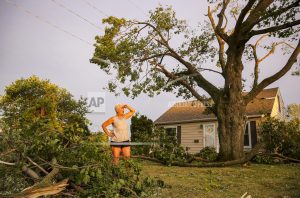
Laurie Berdahl stands in her front yard beginning to clean up downed limbs around her home, Monday, Aug. 10, 2020, in Cedar Rapids, Iowa. Berdahl’s home suffered only minor damage but like most of the city she was without power. (Andy Abeyta/The Gazette via AP)
Many roads remained impassable and businesses closed. City council member Dale Todd says “it feels like we got kicked in the teeth pretty good,” and that recovery will be slow.
IOWA CITY, Iowa (AP) — Hundreds of thousands of residents in Iowa’s three largest cities are without power two days after a rare wind storm hit the Midwest. The storm known as a derecho devastated the state’s power grid, flattened valuable corn fields and left two people dead in Iowa and Indiana. Major parts of Iowa suffered outages Monday as straight-line winds toppled trees, snapped poles and downed power lines. The storm had winds of up to 112 mph near Cedar Rapids, as powerful as an inland hurricane, as it tore from eastern Nebraska across Iowa and parts of Wisconsin, Indiana and Illinois, including Chicago and its suburbs. In Iowa, Des Moines, Cedar Rapids and Davenport still had widespread outages Wednesday morning.


