
The National Weather Service says high temperatures today will end up well into the 90s, with heat index values approaching or exceeding 100 degrees each over portions of central and western Iowa. Breezy southwest winds will increase to 20 to 35 mph this morning. If planning outdoor activities, avoid prolonged exposure to the heat and please take appropriate precautions. Much colder weather will return to Iowa by Tuesday with highs in 48 hours some 40 degrees colder than today! 
Adair-Guthrie County Emergency Management Coordinator Bob Kempf today, reports “All of Adair and Guthrie Counties will be under a Burn Ban effective at Noon today 09-04-2020.” Previously, a Burn Ban was put in place for the City of Stuart, Cass, Audubon and Pottawattamie Counties. The Adair-Guthrie County ban means there should be no burning of yard waste, piled tree debris, grass/agricultural ground and set-asides or other items during the ban. Also, do not toss cigarettes out the window of a moving vehicle!
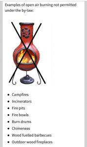
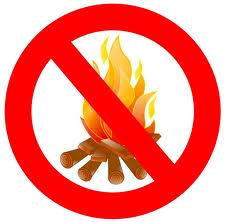 Small recreational patio or camp fires are permitted only if they are conducted in a fire place of brick, metal or heavy one-inch wire mesh. Any camp fire not in an outdoor fire place is prohibited.
Cass County Emergency Management Coordinator Mike Kennon reports a ban on open burning will be in place for Cass County beginning today (Thursday), at 5:00 p.m. The ban prohibits open and controlled burning in Cass County, Iowa; including all incorporated city limits within the county. Kennon says the current drought conditions in combination with unharvested crops present an increased risk for the potential of rapid fire spread. Controlled fires can quickly become uncontrollable.
During these dry conditions, citizens are reminded to not throw out cigarettes from moving vehicles and to discontinue burning yard waste, piled tree debris, grass/agricultural ground and set-asides or other items during the ban. Small recreational patio or camp fires are permitted only if they are conducted in a fire place of brick, metal or heavy one-inch wire mesh. Any camp fire not in an outdoor fire place is prohibited.
Violation of a burn ban can subject a person to citation or arrest for reckless use of fire or disobeying a burn ban. The ban — which was approved by the State Fire Marshal – will remain in place until environmental conditions improve. Any questions regarding this burn ban should be directed to your local Fire Chief.
The latest version of the U-S Drought Monitor shows an expanding area of EXTREME Drought in western and west central Iowa. The conditions mean pastures are dry; producers sell cattle; crops are tested for toxins; and crops may have pest infestation. In addition, seasonal allergies are worse; farmers are stressed about high feed prices, trees drop leaves; acorns are underdeveloped, and warm water leads to fish kills; streambeds are low to dry. Parts of northwest, central and southwest Iowa are categorized as being in a SEVERE drought, while other parts of the State are in a Moderate drought, or are Abnormally dry. No part of the State has escaped the drought conditions.
Unfortunately, little rain is forecast for the next five days at least, that will have any sort of impact on the drought conditions.
For more information, see the Drought Monitor web page at https://droughtmonitor.unl.edu/CurrentMap/StateDroughtMonitor.aspx?IA
Stuart Fire Chief Mike Renslow has sent a request to the office of the State Fire Marshal that open burning be prohibited in the City both in Adair and Guthrie counties. It was therefore ordered that no person shall engage in open burning from now until October 1st at midnight, except as specifically permitted by Iowa Code.
 The ban may be extended or rescinded at any time that such conditions dangerous to life or property no longer exist. Any violation of this proclamation is a simple misdemeanor. Guthrie County has been experiencing moderate to extreme drought conditions for almost two months, according to the U.S. Drought Monitor.
An open burning ban is in-place for Pottawattamie County, until further notice. The ban went into effect at 5-p.m. Tuesday, September 1st. It prohibits all open and controlled burning in Pottawattamie County, Iowa, including all incorporated city limits within the county.
Pott. County EMA
The current drought conditions throughout the county in combination with unharvested crops present an increased risk for the potential of rapid fire spread. Controlled fires can quickly become uncontrollable.
According to the National Oceanic and Atmospheric Administration’s (NOAA) National Integrated Drought Information System (NIDIS) program, Pottawattamie County is currently classified in the Severe Drought (D2) classification. More information on current drought conditions can be found at https://www.drought.gov/drought/states/iowa.
Pott. County Emergency Management Director Doug Reed says “Pottawattamie County has seen the devastating effects of fire in extreme conditions and we want to do everything we can to help mitigate incidents like that from occurring.” During these dry conditions, citizens are reminded to not throw out cigarettes from moving vehicles and to discontinue burning yard waste, piled tree debris, grass/agricultural ground and set-asides or other items during the ban.
Small recreational camp fires are permitted only if they are conducted in a fire place of brick, metal or heavy one-inch wire mesh. Any camp fire not in an outdoor fire place is prohibited.


