
A snow squall that passed through the central section of Iowa Monday morning, left anywhere from as little as one-tenth, to as much as nine inches of snow, catching motorists and others by surprise, and making for slippery, near white-out conditions. Here at KJAN in Atlantic, we picked up just one-tenth of an inch of snow that quickly melted.
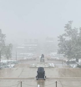
Snowfall at the Iowa State Capitol in Des Moines (10-19-20)
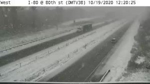
I-80 near Altoona (IA DOT cam) 10-19-20
Elsewhere there was:
DES MOINES, Iowa (AP) — A new report says damage estimates from a rare wind storm that slammed Iowa and some other parts of the Midwest in August are growing. The total is now $7.5 billion. The National Oceanic and Atmospheric Administration said the Aug. 10 storm is currently the second-costliest U.S. disaster so far in 2020, although cost estimates for the widespread wildfires along the West Coast aren’t yet available.
The August storm hit Iowa hard but also caused damage in Illinois, Ohio, Minnesota and Indiana. The most expensive disaster so far this year was Hurricane Laura, which caused $14 billion in damage along the Gulf Coast.
Special Weather Statement National Weather Service Des Moines IA 405 AM CDT Sat Oct 17 2020
Sac-Crawford-Carroll-Audubon-Guthrie-Dallas-Cass-Adair-Madison-Adams-Union-Taylor-Ringgold Counties
…Gusty Winds and Elevated Fire Danger Today…
Winds will increase rapidly by mid morning across central and southeast Iowa with gusts of 40 mph or more expected before diminishing later this afternoon. Farther north and east wind
gusts of 20 to 30 mph will be common. These gusty winds will combine with warm temperatures, fairly low humidities, and drying grasses and crops to produce an elevated fire danger through this afternoon. Any fires that ignite could spread quickly under these conditions, especially across cropland. Burning is not recommended under these conditions. Burn bans are
in effect for multiple central Iowa counties.
Burn Bans continue until further notice, for: Adair-Audubon-Cass-Dallas-Guthrie-Harrison-Mills-Montgomery and Pottawattamie Counties.
Area Counties: Sac-Crawford-Carroll-Audubon-Guthrie-Dallas-Cass-Adair-Madison-Adams-Union-Taylor and Ringgold…
...Elevated Fire Danger Again Today…
Gusty west to northwest winds of 15 to 25 mph with wind gusts in excess of 40 mph will develop later this morning and persist through this evening. Relative humidity values will fall into the
25 to 35 percent range by this afternoon. 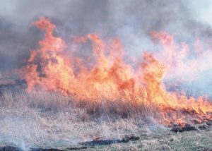 These weather conditions combined with curing grasses and the crop harvest across the state will lead to an elevated fire danger today. Any fires that ignite could spread quickly under these conditions especially in cropland. Burning is not recommended under these conditions.
(Radio Iowa) – The National Weather Service released its annual winter outlook this (Thursday) morning with defined outlooks for either warm and dry or cold and wet conditions going into the winter season. But Climate Prediction Center Deputy Director Mike Halpert says it gets a little bit more complicated when you look at the jetstream and its impact on Iowa.
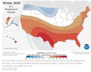 “The Iowa, Wisconsin area oftentimes falls in between or becomes very uncertain as to whether they become drier as a drier signal as the jetstream shifts further north or becomes wetter as it doesn’t shift quite as far,” he says. “So the forecasts for Iowa are actually in the equal chance category so there’s an equal chance for wet or dry, warm or cold.”
Dave Miscus is a drought expert at the C-P-C. He says our temperatures over the next several months will likely dictate what we expect come spring as far as ongoing drought conditions go even if we do end up in a wetter than normal pattern. He says once the soil freezes in the wintertime the soil doesn’t get into the soil and then we have to wait until spring to get any soil moisture recharge.
Miscus says if the soil freezes soon before any more precipitation, we enter the winter waiting. “Not looking too good for removing that drought in especially western Iowa — which has been lingering for the last six to nine months here. We’ll have to wait and see what the spring brings,” Miscus says.
The outlook released Thursday has higher probabilities or colder and wetter conditions to our north along with drier and warmer conditions to the south, but nothing is definitive at this point, especially not knowing exactly how strong the developing La Nina pattern is going to be.
Monona-Harrison-Shelby Counties
336 AM CDT Thu Oct 15 2020
…FREEZE WARNING IN EFFECT FROM 1 AM TO 10 AM CDT FRIDAY…
The National Weather Service in Omaha/Valley has issued a Freeze Warning, which is in effect from 1 AM to 10 AM CDT Friday.
* TEMPERATURES…33 to 29 degrees .
* TIMING… 1 AM to 10 AM
* IMPACTS…Freezing temperatures could kill sensitive vegetation and damage unprotected outdoor plumbing.
* ADDITIONAL INFORMATION… We are now about a week past the typical growing season for the counties in the warning. This will the the last freeze warning of the season.
PRECAUTIONARY/PREPAREDNESS ACTIONS…
A Freeze Warning means sub-freezing temperatures are imminent or highly likely. These conditions will kill crops and other sensitive vegetation.
A Burn Ban is now in effect for Guthrie and Adair Counties, until further notice. Emergency Management Coodinator Bob Kempf reports the State Fire Marshal approved requests from Kempf to prohibit open burning in both counties, until such time as the activity does not constitute a danger to life or property.
 Kempf made the request after consulting with the fire chiefs in each respective county. Any violation of the proclamation order is a simple misdemeanor.
Critical Fire Danger Today…Strong winds NW @ 20-45 mph) and low relative humidity this afternoon will result in rapid spread of any fires that start, and the potential for uncontrollable fires.
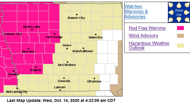
343 AM CDT Wed Oct 14 2020; Area Counties: Cass-Audubon-Guthrie-Monona-Harrison-Shelby-Sac-Crawford and Carroll….
RED FLAG WARNING IN EFFECT FROM 1 PM THIS AFTERNOON TO 8 PM CDT THIS EVENING FOR CRITICAL FIRE DANGER...
* Impacts…Any grassland and field fires that start this afternoon may spread rapidly and become uncontrollable.
 PRECAUTIONARY/PREPAREDNESS ACTIONS…
A Red Flag Warning means that critical fire weather conditions are either occurring now, or will shortly. A combination of strong winds, low relative humidity, and warm temperatures can
contribute to extreme fire behavior.
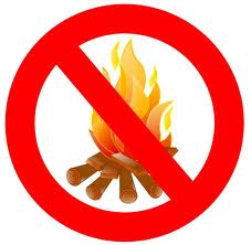
[COUNCIL BLUFFS, IA, October 13, 2020] – Pottawattamie County Emergency Management Director Doug Reed, Tuesday, said “The current weather forecast and environmental conditions indicate a potential for very high to extreme fire behavior on Wednesday, October 14th through Saturday. This includes easy ignition potential and rapid fire spread. Conditions will slightly alleviate but remain high Thursday and Friday, degrading again on Saturday.”
Pott. County EMA
According to Reed, “Fire departments in Pottawattamie County have responded to two large cropland fires over the past week and ask for everyone’s compliance with the current Open Burning Ban. In addition, the Emergency Management Agency is asking all residents to discontinue the use of recreational fire pits, campfire rings, covered burn barrels, and any type of burning through the remainder of this week and weekend.”
“Pottawattamie County,” he said, “has seen the devastating effects of fire in extreme conditions, including firefighter injuries and loss of residential properties and other structures. We want to do everything we can to help prevent unnecessary injuries or devastating property losses from occurring.”
Violation of the existing burn ban, especially actions or negligence causing injury or property loss, can subject a person to citation or arrest for disobeying a burn ban, reckless use of fire, or other applicable statutes. For updated information on conditions you can find further information on the county’s social media, and web pages.
An Open Burning Ban will remain in place until environmental conditions improve.


