
(Radio Iowa) – The 2020 Harvest is speeding toward completion. Ninety-seven percent of soybeans have been harvested. Iowa Ag Secretary Mike Naig says about one-and-a-half MILLION acres of corn was left to be combined when the week started — that’s equal to just 13 percent of this year’s corn crop.
 “We’ve had a historic pace in terms of getting the crop out here, several weeks ahead of the five year average,” Naig says. “We’re well ahead of pace and we’ve got plenty of time here, but it’s especially nice when the weather cooperates as it has here when we flipped the calendar into November.” It’s not unusual at this point in the season to have crop still standing in southern Iowa fields.
The growing season is longer in southern compared to northern Iowa. In the fall of 2019, there was a propane shortage as Iowa farmers were using the fuel to power the driers in grain bins. “This year hasn’t been nearly as much of a demand for propane because the corn has dried down in the field and just simply hasn’t needed it as much, so that’s been a bright spot for farmers,” Naig says. “They’ve been able to save some on that drying cost and that’s always appreciated.”
Up to four million acres of corn was damaged or destroyed by the August 10th derecho. Naig says that contributed to a slower harvest pace in fields where farmers were trying to harvest damaged stalks. “They’ve had to literally go slower or maybe even go one direction in a field,” Naig says. “We also know that there were the compounding issues of grain storage that was damaged due to the wind storm.”
Naig says some farmers had to opt to pile corn on the ground because their grain bins were hit by the derecho.
(Radio Iowa) – Iowans don’t usually see a half-foot of snowfall during October but that’s just one more thing we can chalk up for this bizarre 2020. State climatologist Justin Glisan says the month ended up being one of the coldest Octobers in Iowa history, punctuated by that snow squall mid-month that dumped heavy snow mostly in central Iowa, with some areas like Johnston reporting up to nine inches. It made for a chilly month.
Rainfall during October was a mixed bag, as parts of western and central Iowa were still deep in drought or had very dry conditions, while eastern Iowa got more than its share of precipitation.
So what does the month of November hold? Some forecasters are predicting a “snowmageddon,” but Glisan sees a more gradual move toward an early winter.
Forecast models indicate November may be a wetter-than-average month, which he says could be a big plus to “recharge” the soil in areas of Iowa that have been so dry for much of the year.
Weather records for the month of October in Atlantic have been compiled here at the KJAN Studios (The official National Weather Service reporting site for Atlantic). The data show (as most will attest), that it was a very dry, and somewhat cooler month than what we normally experience. Precipitation (including melted snowfall) amounted to just 1.15 inches, which is 1.61 inches below average. The High averaged out to 59 degrees, which is five-degrees cooler than normal, and the Low was 33, which was six-degrees below normal.
Looking ahead to this month (November): The High is typically 46 and the Low is 27. Precipitation during a normal November would typically amount to 1.85 inches.
(Radio Iowa) – The latest predictions show a La Nina weather system has developed in the Pacific Ocean and it’s expected to linger into spring — which may bring Iowa a colder winter and could influence the state’s weather well into 2021. Matt Rosencrans, a meteorologist at the Climate Prediction Center, says they plan to update the forecast monthly.
“The La Nina forecast goes out about eight months, so if we were doing a forecast back in July, it wouldn’t have extended too far into next year anyway, so that’s one aspect of it,” Rosencrans says. “The other aspect is that you just have more certainty.”
A La Nina system occurs when sea surface temperatures average below-normal. Historically, La Ninas have caused below-normal temperatures across much of the Northern Plains states during the winter. Rosencrans says the center’s predictions are largely based on past observations.
“There’s kind of a new unpredictability die-off in this skill of La Nina at about six months, some seasons, it’s six to seven, in the springtime, it’s only about two to three months,” he says. “We really don’t have a lot of lead time on there.”
Rosencrans says they are confident of the impacts at least through February, while beyond that, there’s still some uncertainty.
(Iowa News Service) IOWA CITY, Iowa — More than 4,000 medical professionals from across the country are demanding policy action on climate change. The coalition includes more than a dozen doctors and nurses from Iowa, who say the effects are visible in the patients they serve. They have signed a letter asking their patients to get behind political candidates willing to consider the issue. John Macatee, a retired doctor from Iowa City who practiced family medicine, said there are concerns within the medical community about climate change resulting in poorer health outcomes. In Iowa, he said, there’s a ripple effect within agriculture. “There’s ever increasing severity of weather changes causing flooding, which is decreasing crop yields, and depression and suicide,” he said.
In a 2019 report from the Iowa Policy Project, the authors predicted that the Midwest will see the biggest spike in premature deaths related to rising temperatures linked to climate change. While polls show more people, including younger conservatives, acknowledging the impact of a warming climate. many candidates still express support for the oil industry. In asking patients to seek out politicians who support action on climate change, Macatee said it isn’t about partisanship. He called this a “human” issue. “Just like COVID, it’s affecting us all,” he said, “whether we’re Republicans or Democrats or Independents.”
One of the groups in the coalition is the Medical Society Consortium on Climate and Health. Some of the key demands include leaders who prioritize renewable energy over fossil fuels, and those who pay close attention to the science and medical communities. The letter is online at medsocietiesforclimatehealth.org, and the Iowa climate report is at iowapolicyproject.org.
Even with the recent rain and snow, much of Iowa’s still far short of precipitation for the year and we’re heading into the drier, colder seasons with little chance of replenishing soil moisture levels before spring. Meteorologist Dennis Todey, who heads the U-S-D-A’s Midwest Climate Hub in Ames, says wide areas of the state are still recovering from long-running drought conditions.
The snow and rain that fell in the past week helps to bring some short-term drought relief, but he says much more precipitation will be needed to recharge depleted soil moisture levels.
Todey says the expected weather patterns don’t look promising for significant rainfall or snowfall, noting, August of 2020 was the driest in Iowa in 148 years.
The latest drought monitor shows very dry conditions over all but extreme eastern Iowa.
OMAHA, Neb. (AP) — Many residents in Nebraska and Iowa are breaking out the shovels and snow blowers following a significant snowfall — including some record snow — over the weekend. The National Weather Service says Norfolk in northeastern Nebraska set a record for snowfall Sunday with 4 inches. That topped the previous Oct. 25 record of 2.7 inches set in 1997. In Sioux City, Iowa, about 3 inches of snow fell, breaking the previous record for the day of 0.7 inches more than a century ago in 1918.
The service says higher totals were seen in other communities Sunday, including 8 inches recorded in Valentine, Bassett and Anselmo in northern Nebraska. Ocheyendan in northern Iowa saw more than 6 inches
Roads in the area are slick this morning from Sunday and overnight snowfall! Be prepared to take it slow on your morning commute. For the latest road conditions in your area check with the Iowa DOT at 511ia.org or download the 511 mobile app.
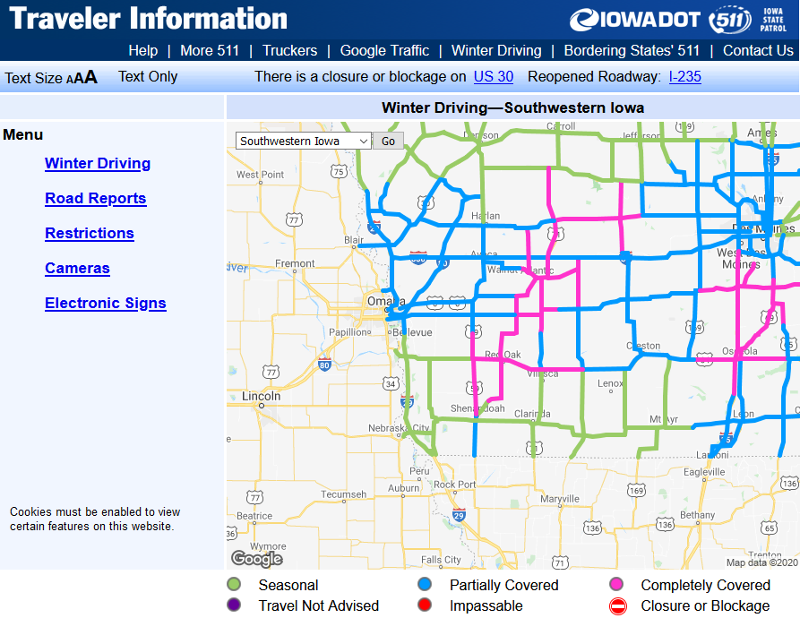
Map updated 6:50 a,m
(Update 3:55-a.m.) Harrison County……A WINTER WEATHER ADVISORY REMAINS IN EFFECT UNTIL 7 AM. Shelby-Pottawattamie-Mills-Fremont Counties…A WINTER WEATHER ADVISORY REMAINS IN EFFECT UNTIL 10 AM
An additional one to two inches of snowfall can be expected. Plan on slippery road conditions. The hazardous conditions could impact the morning commute.
PRECAUTIONARY/PREPAREDNESS ACTIONS…
Slow down and use caution while traveling. The latest road conditions for the state you are calling from can be obtained by calling 5 1 1.


