
(Radio Iowa) – Even with today’s (Monday) heavy snow across a wide portion of Iowa, the soil is frozen and when this snow melts, it’ll likely run off and not be absorbed into the soil. Weather experts are predicting continued drought conditions for the region, with the troubles spreading across Iowa’s western third. Illinois state climatologist Trent Ford moderated the North-Central Region Climate update for the National Weather Service.
“Most areas from the Central Plains westward are still dealing with drought issues,” Ford says. “Forty-five percent of this entire area is in moderate drought or worse. Some places in Nebraska, Colorado, Wyoming, and parts of northwestern Iowa are still dealing with severe to extreme or exceptional drought.” Ford says the dry conditions started early last fall and they’ll continue well into the spring planting season.
“Because of that dry 2020 and the carryover to 2021, we’re still dealing with drought conditions,” Ford says. “Given the mild temperatures for winter so far and the fact that nobody is pushing the record books for precipitation, we really haven’t seen much improvement.” Ford says the outlooks don’t offer much relief and many Iowa farmers could be facing critical problems in just a few months.
“This big block of brown here that we’re showing from western Iowa all the way through California, that is the area where the highest likelihood is drought persistence,” Ford says. “Drought is currently present there, at least moderate drought if not worse, and the prediction is the highest probability of drought persistence, at least through the end of April.” Soil moisture is also depleted across much of the region after several years of above-normal precipitation and record or near-record flooding.
(Radio Iowa) – Experts say the approaching snowstorm has the potential to be the worst to hit Iowa in nearly a decade and forecasters say we need to prepare for very heavy snowfall. Meteorologist Rod Donavon, at the National Weather Service, says a Winter Storm Warning is posted for the southern two-thirds of the state today (Monday) and into tomorrow morning, adding, the snow may fall at the rate of two inches per hour. “Expect conditions to quickly deteriorate. Overall snowfall amounts are forecast anywhere from eight to 13 inches across a large portion of central and southern Iowa,” Donavon says. “It will taper off towards the Highway 20 corridor where we could have anywhere from four to seven inches, and much lighter amounts to the north of that.”
Iowa’s most populous city could get the worst of the snowfall, as the forecast for Des Moines calls for up to nine inches of snow this afternoon and up to seven more inches tonight. That’s the potential for 16 inches of snow. “We’re right in line where that heavier snow band will be developing across the I-80 corridor,” Donavon says. “We’re expecting more, lighter amounts to continue into Tuesday which will add on to those totals.” Iowans who have to drive are advised to consult the Iowa D-O-T’s Traveler Information website, 5-1-1-i-a-dot-org, before heading out, and be flexible as you may need to stay in since snow plows might not be able to keep up with this heavy snow.
“Travel is going to be quite difficult to near-impossible at times as we have those heavier snowfall rates,” Donavon says. “In addition, we are expecting a fair amount of blowing and drifting snow as we have northeast winds, increase to 15 to 25 miles an hour, gusting over 30 at times.” He says the looming storm could easily be the worst yet this winter — and the worst in several winters. “Certainly, it’s one of the biggest snowfalls, especially this widespread, too, across this large portion of the area,” Donavon says. “Certainly, for this season, certainly, for the past several years. Really, for this widespread of a heavy snowfall, you’d need to go back to 2012.”
The forecast is being updated frequently as the storm approaches.
Officials with the National Weather Service in Des Moines say a major winter storm will impact much of central and southern Iowa today and tonight. Snow will increase from south to north through the day, though parts of northern Iowa may have little to no snow today. Very heavy snowfall is expected across much of Iowa along and south of Highway 30 where totals may reach 12 inches or more! The Weather Service predicts 9-to 14-inches around Atlantic, with 10-to 14-inches to the east, over parts of Adair, Dallas, Guthrie and Madison Counties.
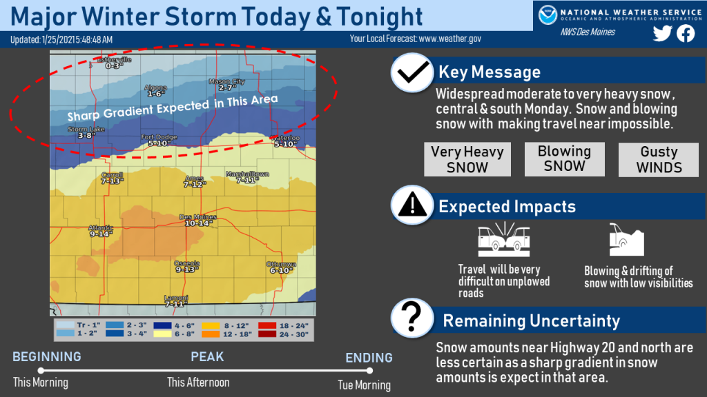 The greatest uncertainty is north of a Fort Dodge to Waterloo line and is why there are large ranges of snowfall expected in those areas. Snow amounts in Mason City, Algona and Estherville areas will likely be on the lower side of the ranges. The snow will be accompanied by brisk winds and blowing snow producing low visibilities in open areas. Travel will be difficult to near impossible on unplowed roads in the heavy snow areas, even not taking into account low visibilities and at times, whiteout conditions. This evening’s commute will be greatly impacted. Light snow will linger Tuesday morning and breezy winds will linger and will prolong the recovery time for this event.
If you must travel, keep an extra flashlight, food, and water in your vehicle in case of an emergency. If you must head out, the latest road conditions can be obtained by calling 5 1 1, and on the web (in Iowa), at 511ia.org.
WINTER STORM WARNING IN EFFECT THROUGH 6-A.M. TUESDAY
Today: Snow. Heavy at times. Blowing snow. High 28. E/NE @ 15-25. Wind chill around 5.
Tonight: Snow/blowing snow. Low 22. E/NE @ 15-25. Wind chill near 0.
Tomorrow: Cloudy w/Light snow ending in the morning. Total accumulation of 8-12″ possible. High 24. N @ 15-25.
Wednesday: Mostly cloudy w/flurries possible. High 20.
Thursday: Partly cloudy. High near 30.
Sunday’s High in Atlantic was 31. Our Low this morning, 22. Last year on this date the High in Atlantic was 33 and Low 25. The Record High on this date was 65 in 1944. The Record Low was -28, in 1894.
Moderate to heavy snows are expected to spread north to south into Iowa Monday morning and continue well through the evening hours. The National Weather Service says this will result in widespread moderate to heavy snow accumulations across central and southern Iowa. Accumulations of a foot or more are possible south. There will also be a sharp gradient in snowfall accumulations somewhere near the Highway 30 corridor.
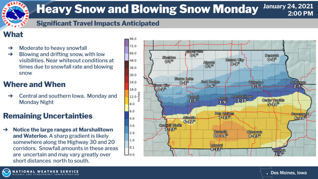 Snow amounts may vary greatly over short distances north to south. Snowfall rates may often be an inch per hour in areas of heavier snowfall. These intense snow rates and northeast winds gusting from 30 to 35 mph will produce near blizzard and whiteout conditions. Travel will be difficult to impossible at times. The snowfall should end Tuesday morning with wind beginning to diminish as well.
LINCOLN, Neb. (AP) — A major winter storm could blanket a large section of the Plains with up to a foot of snow at the start of this week. The National Weather Service has issued a winter storm warning for an area stretching from north-central Kansas across southeast Nebraska and into southern Iowa. The snow is expected to begin early Monday and continue throughout the day.
Most of the region is expected to receive at least six inches of now, but the heaviest snow is predicted to fall on an area starting around Salina and Concordia, Kansas, and continuing northeast to around Des Moines, Iowa.
Today: Mostly cloudy, with a high near 30. Northeast wind 5 to 10 mph.
Tonight: A chance of snow and freezing rain, mainly after 5am. Cloudy, with a low around 17. Wind chill values as low as 5. East northeast wind 8 to 14 mph, with gusts as high as 20 mph. Chance of precipitation is 30%. New snow accumulation of less than a half inch possible.
Monday: **Winter Storm Warning from 6-a.m Monday until 6-a.m. Tuesday**A chance of snow before 7am, then snow and freezing rain likely between 7am and 8am, then snow after 8am. The snow could be heavy at times. Patchy blowing snow after 8am. High near 26. Wind chill values as low as 5. Windy, with an east northeast wind 15 to 21 mph, with gusts as high as 30 mph. Chance of precipitation is 100%. Little or no ice accumulation expected. New snow accumulation of 3 to 7 inches possible.
Monday Night: Snow, mainly before 1am. The snow could be heavy at times. Patchy blowing snow between 9pm and 11pm. Low around 14. Wind chill values as low as 5. Blustery, with a north northeast wind 11 to 17 mph, with gusts as high as 26 mph. Chance of precipitation is 90%. New snow accumulation of 2 to 4 inches possible.
Tuesday: A 50 percent chance of snow before 1pm. Mostly cloudy, with a high near 23. North northeast wind 9 to 11 mph. New snow accumulation of less than a half inch possible.
Tuesday Night: A 40 percent chance of snow after 7pm. Mostly cloudy, with a low around 13.
Wednesday: A 40 percent chance of snow, mainly before 7am. Mostly cloudy, with a high near 23.
Saturday’s High in Atlantic was 29. Our Low this morning, 16. We received .4″ of snow here at the KJAN Studios overnight. Last year on this date the High in Atlantic was 32 and Low 27. The Record High on this date was 66 in 1981. The Record Low was -24, in 1894.
Today: Cloudy w/light snow late this afternoon. High 29. SE @ 10-15.
Tonight: Cloudy w/light snow mixed with freezing drizzle. Low 26. SE @ 5-10.
Tomorrow: Cloudy w/mixed precip (Snow/freezing drizzle) ending in the morning. (1-2″ total) High 30. E @ 10-15.
Monday: Cloudy w/a chance of snow. High 28.
Tuesday: Cloudy w/a chance of flurries. High 28.
Friday’s High in Atlantic was 24. Our Low this morning, 9. Last year on this date the High in Atlantic was 36 and Low 30. The Record High on this date was 60 in 1981. The Record Low was -24, in 1948.
Today: Partly cloudy. High 25. NW-E @ 10-15.
Tonight: P/Cldy to Cldy. Low 13. E @ 5-10.
Tomorrow: Mo. Cldy w/light snow, especially during the afternoon. High 30. SE @ 10-15. Sat. Night: Snow, possibly mixed w/rain late. Low around 25.
Sunday: Cloudy w/a mix of snow-freezing rain ending in the morning. High 30.
Monday: Cloudy w/a chance of light snow. High 28.
Thursday’s High in Atlantic was 41. Our Low this morning, 15. Last year on this date the High in Atlantic was 33 and Low 32. The Record High on this date was 60 in 1967. The Record Low was -27, in 1930.
Today: Partly cloudy. High 39. NW @ 10-20.
Tonight: P/Cldy. Low 15. NW @ 5-10.
Tomorrow: P/Cldy. High 25. N @ 10.
Saturday: Cloudy w/a chance of light snow. High 30.
Sunday: Cloudy w/a chance of light snow/mixed precip ending. High near 30.
Wednesday’s High in Atlantic was 48. Our Low was 24. Last year on this date the High in Atlantic was 34 and Low -8. The Record High on this date was 58 in 1933. The Record Low was -32, in 1976.


