
Today: Areas of fog this morning; Partly cloudy. High 58. SE @ 10 mph.
Tonight: Mostly cloudy w/rain. Low 40. SE winds becoming NE @ 5-10.
Tomorrow: Mo. Cldy w/rain ending in the morning. High 54. N @ 10-15.
Sunday: Mostly sunny. High around 60.
Monday: Mo. Sunny. High 73.
Thursday’s High in Atlantic was 45, and the Low was 38. We received just .01″ rain Thursday. Last year on this date the High in Atlantic was 60, and the Low was 42. The Record High on this date was 88 in 1907, and the Record Low was -2 in 1955.
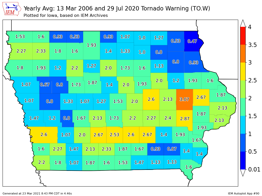
(National Weather Service/Des Moines) – The State of Iowa had its test tornado drill Wed., Mar 24th. In case you are wondering how common is it for a Tornado Warning to affect at least part of your county? The Iowa State University/Iowa Environmental Mesonet crunched the numbers from 2006 to 2020 to find out. (See the graphic) For many Iowans, tornadoes are the most frightening weather phenomena and something that many folks actively run practice drills for. The NWS issues a tornado warning when a tornado is observed and/or indicated to be imminent by Doppler RADAR. The featured map presents the average number of tornado warnings per year by county over the past 15 years.
Please note that the official warning presently are polygon geographies, but the counties are still used by some warning dissemination systems. Linn County (Cedar Rapids) shows up with the highest frequency on the map with other urban centers clearly visible as well. There are many complexities as to why such variability exists over the state, but distance from the nearest RADAR is an important aspect as the earth’s curvature causes the RADAR to miss the lowest parts (which are sometimes the rotating ones) as the beam travels further away from the RADAR site.
Today: Partly cloudy to cloudy w/scattered light rain. High 49. NE @ 10-15.
Tonight: P/Cldy. Low 30.
Tomorrow: Areas of morning fog; P/Cldy to Cloudy. High 58. SE @ 10.
Saturday: Mo. Cldy w/a chance of showers early in the day High 54.
Sunday: P/Cldy. High near 60.
Wednesday’s High in Atlantic was 42. Our Low this morning, 36. We received some light rain between 5-am and 7-a.m. today (Thu.), for a 24-hour total of .01″. Last year on this date the High in Atlantic was 58 and Low 41. The Record High on this date was 91 in 1907. The Record Low was 5, in 1894.
Today: Light rain or drizzle ending later this morning; Mostly cloudy. High 48. NW @ 15-30.
Tonight: P/Cldy to Cldy. Low 35. NW @ 5-10.
Tomorrow: P/Cldy to Cloudy w/isolated showers. High near 50. NE @ 10-15.
Friday: Mo. Cldy w/a chance of showers late in the day High 56.
Saturday: Mo. Cldy w/a chance of showers early. High near 56.
Tuesday’s High in Atlantic was 55. Our Low this morning, 42. Rainfall in Atlantic (at KJAN), from 7-a.m. Tuesday through 6-a.m. today, was .67”. Last year on this date the High in Atlantic was 55 and Low 42. The Record High on this date was 83 in 1967. The Record Low was -2, in 1974.
Iowa Homeland Security and Emergency Management and the National Weather Service have declared the week of March 22 through March 26, 2021 Severe Weather Awareness Week. Severe Weather Awareness Week is an annual event to remind Iowans that severe weather is part of being in Iowa and that understanding the risks and how to respond to them can save lives. The highlight of the week will be a statewide tornado drill on Wednesday, March 24th.
 For this drill, the National Weather Service in Des Moines will issue a mock tornado warning issued at approximately 11:00AM coinciding with weekly weather radio testing. Outdoor warning sirens will be sounded at or soon after 11:00AM in cities throughout Cass County, according to Mike Kennon, Cass County Emergency Management Coordinator. Also, those who subscribe to the Cass County Emergency Notification System will receive an alert concerning the drill. Kennon adds,”This is an excellent opportunity for residents, businesses, and schools to practice their own procedures in the event of a real severe weather event.”
In the event of actual severe weather occurring during or close to the drill time, the drill will be cancelled. To register for the Cass County Emergency Notification System, go to links located on the Cass County homepage or the Cass County EMA Facebook page. If you need assistance, contact Mike Kennon, Cass County Emergency Management Agency Coordinator at 712-243-1500.
Today: Showers & some thunderstorms. High 59. E/SE @ 10-20.
Tonight: Showers & occ. thunderstorms. Low 39. N @ 10-20.
Tomorrow: Cloudy w/morning showers. High 48. NW @ 15-25.
Thursday: Mo. Cldy w/a chance of showers. High near 50.
Friday: Partly cloudy. High 56.
Monday’s High in Atlantic was 49 (24-hour high). Our Low was 39. 24-hour Rainfall in Atlantic was .2”. Last year on this date the High in Atlantic was 47 and Low 37. The Record High on this date was 86 in 1910. The Record Low was 4, in 1974.
(Radio Iowa) – New climate outlooks being issued show a warm and dry trend for Iowa and for much of the country this spring and well into summer. Climatologist Pat Guinan, who moderated the monthly North Central Region climate update for the National Weather Service, says the warming pattern will start in April. “It does look like above-normal temperatures are anticipated across all of the NWS central region,” Guinan says, “and below-normal precip is in the cards, at least according to the forecasters.”
Guinan says the next 90 days shows warm conditions spreading. “We see a lot of the country covered in above-normal temperatures for the April-May-June period,” Guinan says, “We see below-normal precipitation indicated, not good, when you consider much of the western half of the country is still experiencing some form of drought.” The latest map from the U-S Drought Monitor shows much of northern and western Iowa is abnormally dry, with some areas ranging from moderate to severe to extreme drought.
As the La Nina pattern fades, Guinan says the summer forecast indicates continued warm, dry weather. “All of the Corn Belt, we’re forecasting a slight enhanced likelihood of above-normal temperatures this summer,” Guinan says. “That dryness has shifted a little bit toward the north and northeast for the summer, for below-normal precipitation with the highest likelihood extending through the Dakotas, western Minnesota, northwest Iowa, all of Nebraska and northern Kansas.”
In the short term, Guinan says the expectation is for moderate to heavy rain much of this week across Iowa and into the central U-S.
(Radio Iowa) – In the past few weeks, Iowa’s seen a long run of subzero temperatures and snowfall as well as the first Tornado Watch of the year. Today, the first Monday of spring, marks the start of Severe Weather Awareness Week. Meteorologist Chad Hahn, at the National Weather Service in Johnston, says some Iowans could use a refresher course on the dangers that likely lay ahead. Each day will have a different theme. “We talk about the severe thunderstorm criteria, what we use for a Severe Thunderstorm Warning, what we base that on, and that’s either one-inch or larger in diameter hail or 58 mile per hour winds, or greater,” Hahn says.
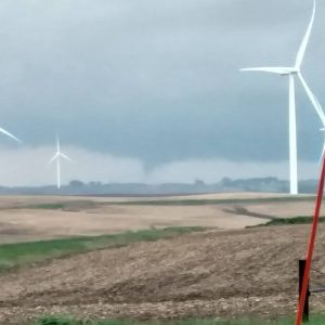
FILE PHOTO – Hope Gettler submitted this photo to the KJAN Facebook page. She said “We watched the rotation that formed a rope like tornado. It bounced up and down for 10 minutes while it was moving northwest towards Guthrie. This was taken 5 miles north of Adair at 320th St and Elm St.”
Tomorrow’s (Tuesday) focus will be on how Iowans get their weather information and the importance of having multiple sources, like weather radios and apps on your phone, in case severe storms knock out your usual source. “On Wednesday, we start to talk about tornadoes and the threat that those pose,” Hahn says, “and the plans that folks should have in their place of business or their home of where they’re going to shelter and have that thought through and that muscle memory in place.”
The annual statewide tornado drill is also planned for Wednesday, but with a small change this year. “We will not be issuing an official National Weather Service tornado warning product,” Hahn says. “Despite that, we still want folks to practice their procedures when it comes to where they’ll go in the event of a tornado. We want folks to drill. That is still an incredibly important part of the Wednesday of Severe Weather Awareness Week.”
Learn more about the week at weather.gov/dmx. There were 28 tornadoes in Iowa last year, and 54 twisters in 2019. Severe weather spotter classes are being offered this Wednesday, as well as March 31st, April 6th and April 19th.


