
Today: Mostly sunny & breezy. High 46. NW @ 10-20.
Tonight: Mostly clear. Low of 16. A light & variable breeze.
Tomorrow: Mostly sunny. High 51. SE @ 10.
Friday: Partly cloudy. High 68.
Friday: Mostly sunny. High 76.
Tuesday’s High in Atlantic was 52. Our Low this morning, 22. Last year on this date the High in Atlantic was 67 and Low 34. The Record High on this date was 87 in 2012. The Record Low was 12, in 1924.
Hazardous Weather Outlook
307 AM CDT Wed Mar 31 2021
This Hazardous Weather Outlook is for much of central and western Iowa….
Today and tonight: Breezy northwest winds and low humidities will continue to produce elevated fire weather conditions today.
Fire danger should rise into the very high category this afternoon over parts of western & southwest Iowa and eastern Nebraska, and could reach the extreme category for a few hours.
Monona-Harrison-Shelby-Pottawattamie Counties
1005 AM CDT Tue Mar 30 2021
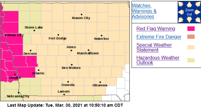 …RED FLAG WARNING IN EFFECT UNTIL 8 PM CDT THIS EVENING FOR WIND AND LOW RELATIVE HUMIDITY…
* Winds…Northwest 20 to 25 mph with gusts up to 35 mph.
* Relative Humidity…As low as 15 percent.
* Impacts…Any fires that ignite may spread rapidly and exhibit extreme fire behavior.
PRECAUTIONARY/PREPAREDNESS ACTIONS…
A Red Flag Warning means that critical fire weather conditions are either occurring now, or will shortly. A combination of strong winds, low relative humidity and warm temperatures can
contribute to extreme fire behavior.
For the rest of the area: Brisk Winds and Elevated Fire Danger Again Today. Although not as windy as Monday, northwest winds will still gust from 25 to 40 mph at times today. It will be cooler as well, but these winds will still combine with drying grasses and low humidities, as low as 25 to 35 percent by afternoon, to produce another day of elevated fire danger.
These winds may blow around unsecured objects and affect high profile vehicles. Also, conditions will be favorable for fires to develop and spread quickly, so avoid outdoor burning.
Today: Partly cloudy to cloudy w/a chance of sprinkles this morning. High 51. NW @ 20-40 mph slowly diminishing.
Tonight: Mostly clear w/a Low of 22. NW @ 5.
Tomorrow: Mostly sunny. High 46. NW @ 10-20.
Thursday: Mo. sunny. High 52.
Friday: P/Cldy. High 65.
Monday’s High in Atlantic was 76. Our Low this morning, 45. Last year on this date, the High in Atlantic was 69 and the Low was 25. The Record High was 87 in 1968, and the Record Low was 8 in 1964.
Today: Mostly Sunny & windy. High 73. S/SW @ 20-40 mph w/gusts to around 50 this afternoon. **RED FLAG WARNING & WIND ADVISORY from Noon until 8-p.m.**
Tonight: Increasing clouds w/a chance of light rain late. Low around 35. S @ 10-20 mph w/gusts to near 40 mph.
Tuesday: Mostly cloudy early w/a chance of morning showers; Becoming P/Cldy. High 51. NW @ 15-30.
Wednesday: Mo. Sunny & breezy, with a high near 46.
Thursday: Mo. Sunny, with a high near 52.
Sunday’s High in Atlantic was 56. Our Low was 31. Last year on this date the High in Atlantic was 59 and Low 24. The Record High on this date was 90 in 1896. The Record Low was 5, in 1969.
A RED FLAG WARNING is in effect from Noon today (Monday) until late this evening all but extreme northeast Iowa, and far western Nebraska, for Extreme Fire Weather Conditions. In addition, a WIND ADVISORY remains in effect from Noon today until late this evening. A combination of warming temperatures, strong southerly wind, low relative humidity, and relatively dry prairie grasses and other fuels will create extreme fire weather conditions. Any fires that start this afternoon may spread rapidly and become uncontrollable.
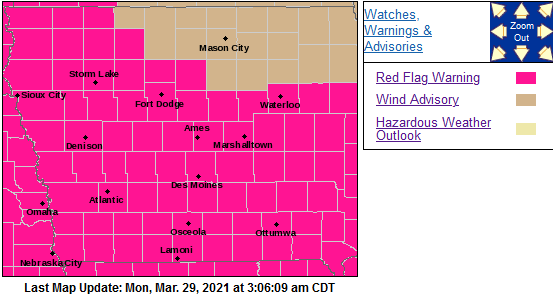
Red Flag Warning for counties shaded in pink
* Relative Humidity…Minimum relative humidity between 20 and 30 percent during the afternoon.
* WIND…Strong south to southwest winds with sustained speeds of 25 to 35 mph, with gusts over 50 mph possible.
* FUEL…Prairie grasses and any lingering crop debris will dry out quickly in these conditions and may be able to burn easily and lead to extremely fast fire growth.
PRECAUTIONARY/PREPAREDNESS ACTIONS…
A Red Flag Warning means that critical fire weather conditions are either occurring now, or will shortly. A combination of
strong winds, low relative humidity, and warm temperatures can contribute to extreme fire behavior.
Sac-Crawford-Carroll-Audubon-Guthrie-Dallas-Cass-Adair-Madison-Adams-Union-Taylor-Ringgold Counties: WIND ADVISORY IN EFFECT FROM NOON TO 8 PM CDT MONDAY, and from Noon until 7-p.m. Monday for Shelby-Pottawattamie-Mills-Montgomery-Fremont-Page Counties.
* WHAT…South winds 20 to 30 mph with gusts up to around 50 mph expected. Strongest wind gusts expected mid to late afternoon.
* IMPACTS…Gusty winds could blow around unsecured objects. Tree limbs could be blown down and a few power outages may result. Use extra caution when driving along east west oriented roadways, especially if operating a high profile vehicle. Secure outdoor objects.
Sac-Crawford-Carroll-Audubon-Guthrie-Dallas-Cass-Adair-Madison-Adams-Union-Taylor-Ringgold Counties: A RED FLAG WARNING IS IN EFFECT FROM NOON TO 8 PM CDT MONDAY FOR EXTREME FIRE CONDITIONS. The Fire Weather Watch is no longer in effect. Any fires that start Monday afternoon may spread rapidly and become uncontrollable. Prairie grasses and any lingering crop debris will dry out quickly in these conditions and may be able to burn easily.
Monona-Harrison-Shelby-Pottawattamie-Mills-Montgomery-Fremont-Page Counties: Red Flag Warning in effect from Noon until 9-p.m. Monday
A Red Flag Warning means that critical fire weather conditions are either occurring now, or will shortly. A combination of strong winds, low relative humidity, and warm temperatures can
contribute to extreme fire behavior.
Today: Sunny & breezy. High near 55. Northwest wind 10-20 mph.
Tonight: Clear, with a low around 41. South wind 10 to 15 mph, with gusts as high as 20 mph.
Monday: Sunny & windy, with a high near 73. SW @ 15-30 w/gusts to around 45. FIRE WEATHER WATCH in effect for critical fire conditions.
Monday Night: Increasing clouds w/a 20% chance of showers after midnight. Low around 37. S/SW winds 10-40 mph.
Tuesday: Mostly cloudy & breezy. High near 49. NW @ 15-25.
Tuesday Night: Partly cloudy, with a low around 26.
Wednesday: Sunny & breezy, with a high near 46.
Saturday’s High in Atlantic was 54. Our Low this morning, 32. Last year on this date, the High was 69 and the Low was 37. The Record High was 84 in 1910 & 1986. The Record Low was 11 in 1898.
(NWS/Des Moines) – Elevated to Extreme Fire Weather Conditions Possible Monday afternoon Central and South. The combination of warm temperatures, strong wind gusts over 40 mph, lower humidities, and relatively dry grasses and fuels may create elevated to extreme fire weather conditions by Monday afternoon central and south.
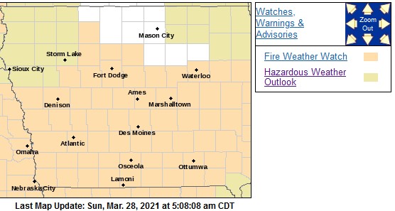 FIRE WEATHER WATCH IN EFFECT FROM MONDAY AFTERNOON THROUGH EARLY MONDAY EVENING FOR EXTREME FIRE CONDITIONS. The National Weather Service in Des Moines has issued a Fire Weather Watch FOR EXTREME FIRE CONDITIONS, which is in effect from Monday afternoon through early Monday evening.
* Relative Humidity…As low as 28 to 32 percent.
* Impacts…Any fires that start Monday afternoon may spread rapidly and become uncontrollable.
* WIND…Strong south to southwest winds with sustained speeds of 25 mph, and gusts of 45 mph possible.
* FUEL…Grasses and any lingering crop debris will dry out quickly in these conditions and may be able to burn easily.
PRECAUTIONARY/PREPAREDNESS ACTIONS…
A Fire Weather Watch means that critical fire weather conditions are forecast to occur. Listen for later forecasts and possible Red Flag Warnings.
Skyscan Forecast Saturday, March 27, 2021 Dan Hicks
Today: Mostly cloudy. Light rain or drizzle early. N @ 10-15. High 54.
Tonight: Partly cloudy. Light and variable winds. Low 30.
Sunday: Mostly sunny. S @ 10-20. High 60.
Sunday Night: Clear. S @ 5-10 with gusts to 20. Low 43.
Monday: Mostly sunny. High 73.
Tuesday: Mostly cloudy. A few showers. High 55.

Podcast: Play in new window | Download (696.9KB)
Subscribe: RSS


