
Effective Noon today (Wed., June 23rd), a Burn Ban is in place for all of Audubon County. Audubon Fire Chief Tyler Thygesen, acting on behalf of all fire departments in the County, requested the ban be issued by the State Fire Marshal’s Office. The ban prohibits any open burning due to the fact conditions in the County are such that any such activity would constitute a danger to life or property.
 No person in Audubon County shall engage in open burning in the County – except as specifically permitted by Iowa Code, until such time as Thygesen notifies the State Fire Marshal that the dangerous conditions no longer exist. Any violation of the Burn Ban is a simple misdemeanor.
(Radio Iowa) – Hail storms blanketed large sections of the state Tuesday afternoon and heavy crop damage is reported in northwest Iowa’s Plymouth County — with thousands of acres impacted. Bill Tentinger, who farms east of Le Mars, says he has extensive hail damage to his corn, especially to the rows that run east-west. “A lot of that in the center of the storm is 100% wiped out. It’s sawed off clear down to the ground,” Tentinger says. “This is corn that was waist high. The rows going north and south have a lot of damage but they’re not sawed off quite that far.”
Photos posted on social media by farmers in the region show hail covering the ground and resembling snow. Tentinger says he may still try to re-plant his soybean acres, though it’s too late in the season to re-plant the cornfields, especially with the chemicals he used.) “On the corn ground, yes, that’s right, there’s herbicide carry-over,” Tentinger says. “I don’t know what the options are on that yet. For those of us that use our corn crops as feed, it’s going to be a pretty good-sized loss.”
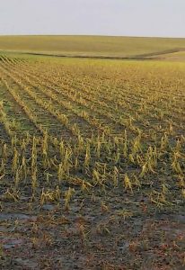
Hail damaged corn on the Bill Tentinger farm
Tentinger says the hail that hit his crops was nickel-sized, but he noticed larger hail stones as he traveled south towards Kingsley. There was damage to windows at farmsteads, along with damaged siding, and some tree damage. Tentinger is facing another challenge — providing for his animals. “I raise mostly corn because I feed it all to my livestock,” Tentinger says. “I’m going to have to replace that somewhere and all of the grain merchandisers in the area are telling me that they have very little corn. Because of the weather, people are reluctant to forward sell.”
The National Weather Service says the largest reported hail in Iowa on Tuesday was in Linn County near Walker with half-dollar-sized stones, while winds topped 66 miles an hour near Des Moines in Waukee.
Today: Partly cloudy. High around 90. SW @ 10-20.
Tonight: P/Cldy w/a scattered showers and thunderstorms. Low 70. S @ 10.
Tomorrow: P/Cldy to cloudy w/scattered shwrs & tstrms. High 86. SE @ 10-15.
Friday: P/Cldy to Cldy w/scatt. shwrs & tstrms. High 86.
Saturday: P/Cldy to Cldy w/scatt. morning shwrs & tstrms. High near 80.
Tuesday’s High in Atlantic was 88. Our Low was 57. Last year on this date, the High was 78 and the Low was 50. The Record High was 105 in 1937. The Record Low was 44 in 1958.
Today: Partly cloudy w/isolated showers & thunderstorms possible, late. High 82. SE @ 10-15.
Tonight: P/Cldy w/a chance of showers and thunderstorms. Low around 65. S @ 5-10.
Tomorrow: P/Cldy, warm & humid. High near 90. SW @ 10-20.
Thursday: P/Cldy to Cldy w/scatt. shwrs & tstrms. High 87.
Friday: P/Cldy to Cldy w/scatt. shwrs & tstrms. High 84.
Monday’s High in Atlantic was 74. Our Low was 48. Last year on this date, the High was 81 and the Low was 55. The Record High was 100 in 1933. The Record Low was 39 in 1972.
A National Weather Service Preliminary Storm Survey team will head to Pella today (Monday), to assess the duration, path and intensity of a tornado that touched down near Pella, Sunday evening.The data will include a damage assessment. No injuries were reported in connection with the storm. The results and conclusions of the survey will be completed and released by the NWS on their website, sometime later today.
Hail the size of eggs fell five-miles north/northeast of Afton at around 4:30-p.m. Sunday. Hail ranging in size from a half-dollar to ping pong balls fell over parts of Poweshiek and Decatur Counties, Sunday evening. Pea-to- ping pong ball-size hail fell over Decatur County. A farm grain bin was tossed onto the middle of Highway 69 near Leon, in Decatur County. Heavy rain (2.35″) was reported in Warren County, as storms developed over southern and southeastern Iowa.

Pella Tornado photo by Robert Carruthers via the National Weather Service’ Facebook page.
Today: Mostly sunny this morning, becoming partly cloudy this afternoon. High near 76. NW @ 10-20, w/gusts as high as 30 mph.
Tonight: Mostly clear, with a low around 52. Winds becoming light and variable.
Tomorrow: P/Cldy w/a slight chance of afternoon showers and thunderstorms. High around 82. S/SW @ 10-15.
Wednesday: P/Cldy w/isolated showers & thunderstorms ending in the morning. High 86.
Thursday: P/Cldy to cldy w/scattered showers and thunderstorms. High near 87.
Sunday’s High in Atlantic was 87. We received .1″ rain yesterday. Our Low this morning, 55. Last year on this date, the High was 89 and the Low was 65. The record High was 101 in 1988 and the Record Low was 38 in 1902.
(Radio Iowa) – A University of Iowa environmental engineering professor says it will take ten BILLION dollars to address the state’s water quality issues and reduce the likelihood of flooding. Larry Weber conducts research on flooding AND water quality. “If we could spend $200 million a year and divide $200 million into $10 billion, that’s 50 years,” Weber says. “So like we’ve changed the way soil comes off the land in the last 50 years, we could change the way water and nutrients come off the land in 50 years, but we need the political will to do it.”
Weber says the 2023 Farm Bill could include rules to reduce farm run-off that would apply not just to Iowa farmers, but to all U-S ag operations. “We’ve had a lot of talk,” Weber says. “The talk has been going on now for a decade or more and we’re just simply not making the progress that Iowans should expect to receive.”
Weber says the drought in much of Iowa will have an impact on water quality, too, since corn and soybean plants in dry soil are not absorbing as much of the commercial fertilizer and manure that’s been applied to fields. “When we do get rain and the water starts to flow and our tiles flow again, we will likely see a real large movement of nitrates coming out of our farm system,” Weber says.
Some Iowa utilities that provide drinking water use surface water from rivers, but about 75 percent of Iowans get their drinking water from underground supplies. “That water has taken tens of thousands and in some cases millions of years to accumulate in those deep aquifers, but it too will be stressed,” Weber says. “Those resources, although ample today, will not be endless. We will have to start thinking about what we will do at the end of the turn of the century, especially as these floods and droughts become more prevalent in our state.”
Weber made his comments this weekend on “Iowa Press” on Iowa P-B-S.
Today: Showers and thunderstorms likely before noon, then a chance of showers and thunderstorms after 3pm. Cloudy, then gradually becoming mostly sunny, with a high near 87. East southeast wind 9 to 14 mph becoming west northwest in the afternoon. Winds could gust as high as 21 mph. Chance of precipitation is 70%. New rainfall amounts between a quarter and half of an inch possible.
Tonight: A 10 percent chance of showers and thunderstorms before 7pm. Partly cloudy, with a low around 56. Breezy, with a north northwest wind 9 to 17 mph, with gusts as high as 24 mph.
Monday: Mostly sunny, with a high near 72. Breezy, with a north northwest wind 10 to 18 mph, with gusts as high as 26 mph.
Tuesday: A slight chance of showers between 1pm and 4pm, then a slight chance of showers and thunderstorms after 4pm. Mostly sunny, with a high near 82. Chance of precipitation is 10%.
Wednesday: Sunny, with a high near 89. Breezy.
Saturday’s High in Atlantic was 91. Our Low this morning was 65. We received .92″ rain overnight at the KJAN Studios in Atlantic. Last year on this date, the High was 82 and the Low was 61. The Record High was 101 in 1937 & 1988. The Record Low was 40 in 1961.
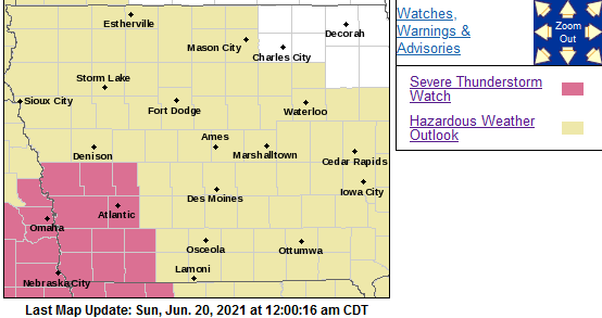
NWS STORM PREDICTION CENTER NORMAN OK 1155 PM CDT SAT JUN 19 2021 SEVERE THUNDERSTORM WATCH 292 IS IN EFFECT UNTIL 500 AM CDT FOR THE FOLLOWING LOCATIONS: IOWA COUNTIES INCLUDED ARE…. ADAMS AUDUBON CASS FREMONT HARRISON MILLS MONTGOMERY PAGE POTTAWATTAMIE SHELBY TAYLOR.
PRIMARY THREATS INCLUDE… SCATTERED DAMAGING WIND GUSTS TO 70 MPH POSSIBLE. ISOLATED LARGE HAIL EVENTS TO 1.5 INCHES IN DIAMETER POSSIBLE. A TORNADO OR TWO POSSIBLE.
PROBABILITY TABLE: PROB OF 2 OR MORE TORNADOES : 20%
PROB OF 1 OR MORE STRONG /EF2-EF5/ TORNADOES : <02%
PROB OF 10 OR MORE SEVERE WIND EVENTS : 50%
PROB OF 1 OR MORE WIND EVENTS >= 75 MPH : 20%
PROB OF 10 OR MORE SEVERE HAIL EVENTS : 30%
PROB OF 1 OR MORE HAIL EVENTS >= 2 INCHES : 10%
PROB OF 6 OR MORE COMBINED SEVERE HAIL/WIND EVENTS : 80%
MEAN STORM MOTION /MPH/ : NE 45
Today: Partly cloudy to cloudy. High 88. E @ 5-10.
Tonight: P/Cldy to cloudy w/scattered late showers & thunderstorms. Low 70. SE @ 10.
Tomorrow: P/Cldy to Cldy w/scattered showers & thunderstorms. High 88. SW-NW @ 10-20.
Monday: P/Cldy. High 78.
Tuesday: P/Cldy. High 82.
Friday’s High in Atlantic was 88. Our Low was 64. We received pea-to-half-dollar size hail at around 11:30-p.m., Friday. Rainfall amounted to .32″. Last year on this date, the High in Atlantic was 75 and the Low was 69. The Record High was 104 in 1974, and the Record Low was 42 in 1900.


