
Today: Mostly sunny. High 95. SW @ 10-15.
Tonight: Fair to partly cloudy. Low 72. S @ 5.
Tomorrow: Mostly Sunny. High 98. EXCESSIVE HEAT WATCH from 10-a.m. to 8-p.m. Wednesday. Hea index as high as 103. SW @10-15.
Thursday: P/Cldy w/isolated showers & thunderstorms possible. High near 93.
Friday: P/Cldy w/scattered showers and thunderstorms. High 87.
Monday’s High in Atlantic was 89. Our Low was 56. Last year on this date, the High in Atlantic was 89 and the Low was 57. The Record-High was 105 in 1930, and the Record Low was 41 in 2013.
With excessive heat expected to persist through this workweek, facilities in Cass County have opened their doors to people who need a break from the extreme heat. Libraries in Cass County will be available as cooling stations during their regular operating hours throughout this week. The Nishna Valley YMCA in Atlantic will also serve as a Cooling Station. SWIPCO Transit Director Mark Lander says SWIPCO “will provide free rides this week for folks that need to get to cooling stations. All they have to do is call for a ride and tell us they need to go to a cooling station.” Call (712)-243-4196 if you need a ride to a cooling center.
Cass County Emergency Management Coordinator Mike Kennon would like to thank the area libraries, the YMCA and their staffs for providing this important service. “We are heading into a stretch of hot temperatures and very high heat indexes for the region. Drink plenty of fluids, avoid strenuous outdoor activity during the heat of the day, stay out of the sun, and check on relatives, neighbors, the elderly and pets. Anyone overcome by heat should be moved to a cool and shaded location. Heat stroke is an emergency…call 9-1-1.”
(Radio Iowa) – With last year’s derecho, Iowans learned the hard way that highly destructive weather events can be something other that tornadoes or floods. Technically, the derecho was a severe thunderstorm, the most destructive thunderstorm in U-S history. National Weather Service meteorologist Alex Krull says they’re soon adding severe thunderstorms — and, thus, any future derecho — to an important alert system.Krull says, “Any severe thunderstorms that we believe will produce damaging wind gusts in excess of 80 miles per hour or produce hail sizes baseball or larger will now activate the wireless emergency alerts on your cell phones.”
Starting August 2nd, the National Weather Service will be able to better convey the severity and potential impacts from major thunderstorms to the public — in seconds. “Now, they will activate the wireless emergency alerts on your mobile phones,” Krull says. “This will occur for all tornado warnings, as has been in the past few years, for flash flood warnings that are either deemed to be considerable or catastrophic, and now for severe thunderstorm warnings as well.”
On average, only about ten-percent of all severe thunderstorms reach the “destructive” category, things like a derecho or a “supercell” storm. When the rare ones hit, people need to know — and right away — so the alert system is being expanded. “For most cell phones, it should automatically happen,” Krull says. “Some folks do have the alerts turned off on their cell phones, depending on whether you’re using an iPhone or some kind of Android device, you may want to check the settings for what your wireless emergency alerts are set to.”
The powerful derecho that struck August 10th of 2020 packed winds up to 140 miles an hour — the equivalent of a category four hurricane — and it caused more than 13-billion dollars damage, most of it in Iowa. The storm started causing havoc in western Iowa and moved quickly eastward, doing its worst destruction in the Cedar Rapids area, eventually dissipating in Illinois. In many respects, it was like having a 150-mile long tornado that was 50 miles wide.
Today: Partly-to-mostly sunny. High 92. S @ 5-10.
Tonight: Fair to partly cloudy. Low around 68. South wind 5-10.
Tomorrow: Mostly Sunny, with a high near 95. Heat index values as high as 103. S @ 5-10.
Wednesday: Sunny and hot, with a high near 98. (Excessive Heat Watch in effect )
Thursday: P/Cldy w/a slight chance of isolated showers and thunderstorms. High 94.
Sunday’s High in Atlantic was 88. Our Low this morning, 56. Last year on this date, the High in Atlantic was 80 and the Low was 68. The Record-High was 109 in 1936, and the Record Low was 43 in 1962.
Today: Patchy fog before 7am. Otherwise, mostly sunny, with a high near 90. Light east southeast wind.
Tonight: Partly cloudy, with a low around 63. Light south southeast wind.
Monday: Sunny, with a high near 91. Calm wind becoming south 5 to 9 mph in the morning.
Monday Night: Mostly clear, with a low around 66. South wind 5 to 7 mph.
Tuesday: Sunny, with a high near 94. Calm wind becoming south southwest 5 to 8 mph in the morning.
Tuesday Night: Mostly clear, with a low around 69.
Wednesday: Sunny and hot, with a high near 97.
Saturday’s High in Atlantic was 91. Our Low this morning, 61. Last year on this date the High in Atlantic was 93 and the Low was 76. The Record High on today’s date (And ALL-TIME record High in Atlantic), was 117 in 1936. The Record Low was 44 in 1894.
(Radio Iowa) – Iowa’s dry conditions held about the same in the last week with around 70 percent of Iowa in some form of drought — and around 25 percent with severe drought conditions. D-N-R hydrologist, Tim Hall, says the overall picture is still better than we had one month ago. “The numbers are better from this time in June until now. We’ve reduced the coverage of drought across the northern part of the state — so the rains have helped,” Hall says. “All of southeastern Iowa across the southern tier of counties is free from drought and dryness.” Hall says.
He says the average stream flows across the state are around normal — which is a little misleading.”It’s really wet in southeastern Iowa. It’s kind of dry in north-central Iowa — so the average number belies the fact that there are areas of the state on either end of the extreme. Still the area that we are concerned about that were are trying to keep a careful watch on is north-central Iowa down through central Iowa through the Des Moines River and the Raccoon River.” Hall says the long-term forecast is a concern.
“So taking us through the end of July there’s very little rain in that forecast for most of the state of Iowa. So, dry conditions, not a lot of rainfall. We might expect to see a deterioration on the landscape that would be reflected in the drought monitor,” Hall says. Hall says we are in a situation where things can flip in a real positive direction or go the other way in a real negative direction depending on how much rainfall does come.
“We might expect to see some downgrading of parts of the state here in the next couple of weeks unless we get some rain,” according to Hall. The new drought monitor will come out on Thursday.
Skyscan Forecast Saturday, July 24, 2021 Dan Hicks
Today: Partly cloudy. S @ 5-10. High 93.
Tonight: Fair to partly cloudy. Light and variable winds. Low 70.
Sunday: Partly cloudy. S @ 5-10. High 93.
Sunday Night: Partly cloudy. Light S winds. Low 65.
Monday: Partly cloudy. A few isolated thunderstorms. High 91.
Tuesday: Partly cloudy. High 94.
Today: Partly cloudy. High 92. Southwest wind 10-15 mph, with gusts to around 20.
Tonight: Partly cloudy, with a low around 71. South wind 5 to 10 mph.
Saturday: P/Cldy. High near 93. S/SW @ 5-10.
Sunday: P/Cldy. High near 92.
Monday: P/Cldy w/isolated showers and thunderstorms. High around 91.
Thursday’s High in Atlantic was 84. Our Low this morning, 69. Last year on this date the High in Atlantic was 88 and the Low was 60. The Record High on this date was 105 in 1901. The Record Low was 45 in 1904 & 1956.
Area Counties: Adams-Union-Taylor-Ringgold-Mills-Montgomery-Fremont-Page
317 AM CDT Fri Jul 23 2021
…HEAT ADVISORY IN EFFECT FROM NOON SATURDAY UNTIL 8 PM CDT SATURDAY…
* WHAT…High temperatures in the mid 90s with heat index values up to 105 expected.
* IMPACTS…Hot temperatures and high humidity may cause heat illnesses to occur.
PRECAUTIONARY/PREPAREDNESS ACTIONS…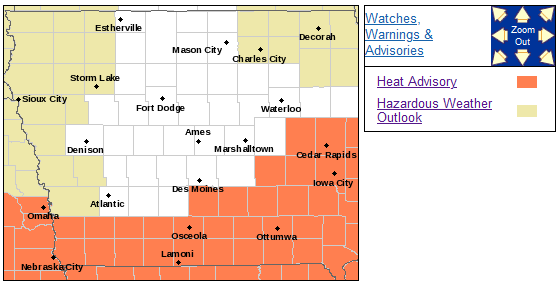
Drink plenty of fluids, stay in an air-conditioned room, stay out of the sun, and check up on relatives and neighbors. Young
children and pets should never be left unattended in vehicles under any circumstances. Take extra precautions if you work or spend time outside.
When possible reschedule strenuous activities to early morning or evening. Know the signs and symptoms of heat exhaustion and heat stroke. Wear lightweight and loose fitting clothing when possible. To reduce risk during outdoor work, the Occupational Safety and Health Administration recommends scheduling frequent rest breaks in shaded or air conditioned environments. Anyone overcome by heat should be moved to a cool and shaded location.
Heat stroke is an emergency! Call 9 1 1.
Today: Partly Cloudy. High near 90. S @ 10 mph.
Tonight: Fair to P/Cldy. Low around 68. S @ 5.
Tomorrow: P/Cldy. High 93. SW @ 10-15.
Saturday: P/Cldy. High 93.
Sunday: P/Cldy. High 91.
Wednesday’s High in Atlantic was 85. Our Low was 57. Last year on this date the High in Atlantic was 87 and the Low was 60. The Record High on this date was 109 in 1901. The Record Low was 45 in 1956.


