
Cass and parts of surrounding counties are still experiencing drought conditions. The latest Drought Monitor released today (Thursday), indicates all of Cass, Adair, and Mills Counties are Abnormally Dry. Most of Audubon and Madison Counties are also Abnormally Dry, with a section of Guthrie and most of Dallas County in a Moderate Drought. Other counties in the area experiencing abnormally dry soil conditions include: the eastern half of Pott. County; the southeastern part of Shelby County; the northwestern half of Adams County; and about two-thirds of Fremont and Page Counties.
Extreme Drought continues to plague all or parts of 11 counties in northeastern Iowa, and parts of five northwest/central Iowa, closest to the Minnesota border.
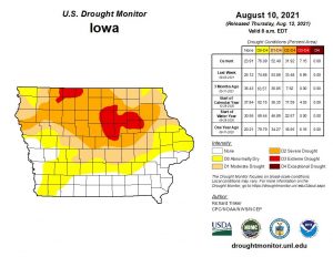
The Drought Monitor map released 8/12/21
Today: Partly cloudy w/isolated showers & thunderstorms possible this afternoon. High 92. Winds light & variable @ 5-10 mph.
Tonight: P/Cldy to cloudy w/isolated shwrs & tstrms. Low 63. N @ 5mph.
Tomorrow: P/Cldy. High around 86. N @ 5-10 mph.
Saturday: P/Cldy. High 86.
Sunday: P/Cldy to cldy w/scattered showers & tstorms. High around 84.
Wednesday’s High in Atlantic was 91. Our Low this morning, 63. Last year on this date the High in Atlantic was 86 and the Low was 70. The Record High on this date was 108 in 1936. The Record Low was 42 in 2004.
Today: **HEAT ADVISORY from Noon until 7-p.m.**Partly cloudy, warm & humid, w/isolated thundershowers possible this afternoon. High 93. S @ 10. Heat Index 105 or more is possible
Tonight: P/Cldy w/isolated thundershowers. Low 73. S @ 5mph.
Tomorrow: P/Cldy w/Isolated showers late. High around 91. Variable wind @ 5-10 mph.
Friday: Isolated showers early. Becoming P/Cldy. High 86.
Saturday: P/Cldy. High around 86.
Tuesday’s High in Atlantic was 91. Our Low this morning was 76. Last year on this date, the High in Atlantic was 87 and the Low was 55. The Record High was 104 in 1894, and the Record Low was 40, in 1902.
Audubon-Guthrie-Dallas–Cass-Adair-Madison-Adams-Union-Taylor-Ringgold Counties….A HEAT ADVISORY REMAINS IN EFFECT FROM NOON TODAY TO 7 PM.
Pottawattamie-Mills-Montgomery-Fremont-Page Counties…A HEAT ADVISORY REMAINS IN EFFECT TODAY FROM 11 AM TO 9 PM.
* WHAT…Heat index values of 105 or greater expected.
* IMPACTS…Hot temperatures and high humidity may cause heat illnesses to occur.
PRECAUTIONARY/PREPAREDNESS ACTIONS…
Drink plenty of fluids, stay in an air-conditioned room, stay out of the sun, and check up on relatives and neighbors. Young
children and pets should never be left unattended in vehicles under any circumstances.
Take extra precautions if you work or spend time outside. When possible reschedule strenuous activities to early morning or evening. Know the signs and symptoms of heat exhaustion and heat stroke. Wear lightweight and loose fitting clothing when possible. To reduce risk during outdoor work, the Occupational Safety and Health Administration recommends scheduling frequent rest breaks in shaded or air conditioned environments. Anyone overcome by heat should be moved to a cool and shaded location.
Heat stroke is an emergency! Call 9 1 1.
Today: Partly Cloudy w/isolated showers & thunderstorms. High 92. HEAT ADVISORY in effect until 7-p.m.. Heat index values as high as 106. S @ 10-15 mph.
Tonight: P/Cldy w/isolated shwrs & tstrms. Low around 72. S @ 5-10.
Tomorrow (Wednesday): P/Cldy w/scattered shwrs & tstrms. High 92. S @ 10-15.
Thursday: P/Cldy w/scatt. Shwrs & tstrms. High 89.
Friday: Scattered shwrs & tstrms early. P/Cldy. High 86.
Monday’s High in Atlantic was 91. Our Low was 65. Last year on this date the High in Atlantic was 84 and the Low was 54. The Record High on this date was 105 in 1894. The Record Low was 42 in 1967.
(Radio Iowa) – The Farm Bureau estimates last year’s derecho caused nearly half a billion dollars in damage to Iowa crops. Rod Pierce, who farms near Woodward, is still working on repairing some of his grain bins and two of the bins will be replaced in the next few weeks. “One of the things my wife did — we had never heard of a derecho and so she basically renamed it ‘Gone with the Wind’ so that seems to fit the name of what happened better than, I think, derecho,” he says.
Pierce says he’s lucky to have had not only good crop insurance, but insurance on structures and vehicles that covered the replacement value of the property. Trees were tipped over and snapped off and he still has toppled trees to clear away. “I knew we’d lost trees, but I never thought that’d be one of the things I’d miss a lot is the nice shade and the beauty of some of the trees that got damaged and insurance didn’t pay me for anything, but my insurance did a good job,” Pierce says. “I was very, very blessed to have good insurance.”
Pierce says his operation suffered 750-thousand dollars in crop damage. Unfortunately, Pierce had to submit a new claim last month. A storm with tennis-ball-sized hail ripped through four of his corn fields, shattered skylights in his house and damaged vehicles. “Luckly, God was with me and I did have some hail insurance,” Pierce says, “but we are experiencing weather at this location, I guess.” Wind speeds from LAST year’s derecho reached 131 miles an hour as the storm passed over Pierce’s farm.
Guthrie-Dallas Counties: HEAT ADVISORY REMAINS IN EFFECT FROM NOON TODAY TO 7 PM CDT THIS EVENING…
* WHAT…Heat index of up to 105 degrees.
Cass-Adair-Madison-Adams-Union-Taylor-Ringgold Counties: HEAT ADVISORY REMAINS IN EFFECT UNTIL 7 PM
Pottawattamie-Mills-Montgomery-Fremont-Page Counties:
…HEAT ADVISORY REMAINS IN EFFECT UNTIL 9 PM THIS EVENING…
…HEAT ADVISORY IN EFFECT FROM 11 AM TO 9 PM WEDNESDAY…
* WHAT…For the first Heat Advisory, heat index values up to 106. For the second Heat Advisory, heat index values up to 108 expected.
Harrison-Shelby Counties: HEAT ADVISORY IN EFFECT FROM 11 AM TO 9 PM WEDNESDAY…
* WHAT…Heat index values up to 105 expected.
* IMPACTS…Hot temperatures and high humidity may cause heat illnesses to occur.
PRECAUTIONARY/PREPAREDNESS ACTIONS… Drink plenty of fluids, stay in an air-conditioned room, stay out of the sun, and check up on relatives and neighbors. Young children and pets should never be left unattended in vehicles under any circumstances. Take extra precautions if you work or spend time outside. When possible reschedule strenuous activities to early morning or evening. Know the signs and symptoms of heat exhaustion and heat stroke. Wear lightweight and loose fitting clothing when possible. To reduce risk during outdoor work, the Occupational Safety and Health Administration recommends scheduling frequent rest breaks in shaded or air conditioned environments. Anyone overcome by heat should be moved to a cool and shaded location. Heat stroke is an emergency! Call 9 1 1.
(Radio Iowa) – Severe thunderstorms with damaging winds rolled over Iowa last (Sunday) night, according to meteorologist Andrew Ansorge at the National Weather Service in Johnston says “We do have a report of a tornado about half way between Fort Dodge and Harcourt around 11:30 last evening,” Ansorge says. “That’s the only tornado report we’ve had. We’ve heard lots of reports of funnel clouds but no real damage that we’ve heard of at this time.”
There’s since been a second tornado confirmed in northwest Iowa’s Osceola County, just before five o’clock last night that ripped the roof off a chicken barn in Ocheyedan, though no injuries are reported. Ansorge say there’s another chance of thunderstorms on Tuesday.
Today: Areas of fog this morning; Partly-to- Mostly Sunny. High 94. HEAT ADVISORY in effect at NOON. Heat index values as high as 103. SW @ 10-15 mph.
Tonight: P/Cldy. Low around 72. S @ 5-10.
Tomorrow (Tuesday): P/Cldy w/isolated early and late day showers possible. High near 90. Heat index values as high as 102. W/SW @ 10-15.
Wednesday: P/Cldy w/isolated early & late showers. High around 90.
Thursday: P/Cldy. High 89.
Sunday’s High in Atlantic was 82. Our Low this morning, 66. Last year on this date the High in Atlantic was 91 and the Low was 72. The Record High on this date was 111 in 1934. The Record Low was 44 in 1927.
Cass-Adair-Madison-Adams-Union-Taylor-Ringgold Counties: A HEAT ADVISORY IS NOW IN EFFECT FROM NOON TODAY (MONDAY) TO 7 PM TUESDAY for a Heat index in excess of 100 degrees expected, and possibly over 105 degrees at times.
Pottawattamie-Mills-Montgomery-Fremont-Page Counties: A HEAT ADVISORY NOW IN EFFECT FROM NOON TODAY TO 9 PM TUESDAY for Heat index values up to 108 this afternoon, then cool to only between 75 and 80 tonight. The heat index will again be near 105 Tuesday afternoon and evening.
IMPACTS…Hot temperatures and high humidity may cause heat illnesses to occur.
ADDITIONAL DETAILS…Temperatures and heat index values will decrease tonight into Tuesday morning, however overnight low temperatures will only be in the mid 70s with very high humidity, leading to a cumulative heat hazard impact.
PRECAUTIONARY/PREPAREDNESS ACTIONS… Drink plenty of fluids, stay in an air-conditioned room, stay out of the sun, and check up on relatives and neighbors. Young children and pets should never be left unattended in vehicles under any circumstances. Take extra precautions if you work or spend time outside. When possible reschedule strenuous activities to early morning or evening. Know the signs and symptoms of heat exhaustion and heat stroke. Wear lightweight and loose fitting clothing when possible. To reduce risk during outdoor work, the Occupational Safety and Health Administration recommends scheduling frequent rest breaks in shaded or air conditioned environments. Anyone overcome by heat should be moved to a cool and shaded location. Heat stroke is an emergency! Call 9 1 1.


