
(Radio Iowa) – Forecasters say heavy showers are likely this (Friday) afternoon and evening for western and central Iowa, but it would take many more rains to make a dent in the long-running — and worsening — drought. State climatologist Justin Glisan says the new drought maps released late this week show drought conditions widening and getting more severe, especially across Iowa’s northern half.
“We’ve had drought expand across the state, especially the D-3 category, which is extreme drought,” Glisan says. “Looking at the previous maps, this is the largest extent that we’ve seen across northern Iowa since the early part of April in 2013.” The new climate outlook was issued for the region on Thursday and Glisan says it holds no obvious signs for what’s to come in the long-term.
“We have an equal chance of above, below or near-average temperature and precipitation behavior in the month of September,” Glisan says. “Then looking at meteorological fall — September, October, November — we do see elevated chances of warmer temperatures but again no clear signal for the precipitation side.” Fall will arrive in about a month, September 22nd, and Glisan says it’s a toss-up as to what the season ahead may hold.
“We do have a pretty good chance of moving back into a La Nina phase of the El Nino southern oscillation which impacts the jetstream over the United States,” Glisan says. “If we look at analog years in which La Nina has returned to the state, we don’t get a clear signal on precipitation behavior.”
The map shows at least parts of 22 Iowa counties are now in extreme drought, which covers more than ten percent of the state, up from around seven-percent last week. Fifty-five percent of the state is now in some level of drought, while almost 79-percent of Iowa ranges from abnormally dry to extreme drought. Only a few counties in southwest Iowa and most of the southern two tiers of counties are untouched by the dry weather.
TODAY: Partly cloudy, a few scattered showers possible mid to late morning, redeveloping later in the day S@ 15-25 High 89
TONIGHT: Mostly cloudy, scattered showers and t-storms S@ 5-10 Low 65
SATURDAY: Partly cloudy NW@ 10-15 High 84
SUNDAY: Partly cloudy, some afternoon showers and t-storms High 87
MONDAY: Some morning showers and t-storms, then partly cloudy High 90
Today: Partly cloudy S@ 10-20 mph High around 90
Tonight: Partly cloudy S@ 5-10 mph Low around 70
Friday: Partly cloudy with a few showers and thunderstorms developing S@10-20 High 90
Friday night: Partly cloudy with showers and thunderstorms likely
Saturday: Partly cloudy High 85
Sunday: Partly cloudy with scattered showers and thunderstorms High 85
Skyscan Forecast Wednesday, August 18, 2021 Dan Hicks
Today: Partly cloudy. S @ 10-20. High 91.
Tonight: Fair to partly cloudy. S @ 5-10. Low 68.
Thursday: Partly cloudy. S @ 10-20. High 91.
Thursday Night: Partly cloudy. S @ 5-10. Low 70.
Friday: Partly cloudy to cloudy. Scattered showers and t’storms. High 85.
Saturday: Decreasing clouds. High 85.
Yesterday’s high was 89 degrees and the low was 64. This day last year the high was 85 and the low was 48. The all-time record high was 111 set in 1936. The record low was 40 set in 2012. Sunset tonight is 8:15 p.m. and Sunrise tomorrow is 6:32 a.m.
Skyscan Forecast Monday, August 17, 2021 Dan Hicks
Today: Partly cloudy. SE @ 10-15. High 89.
Tonight: Fair to partly cloudy. SE @ 5. Low 67.
Wednesday: Partly cloudy. SE @ 10-20. High 91.
Wednesday Night: Mostly clear. S @ 5-10. Low 66.
Thursday: Partly cloudy. High 91.
Friday: Partly cloudy to cloudy. Scattered showers and thunderstorms. High 85.
Yesterday’s high at the KJAN studios was 86 and the low was 56. This day last year we had a high of 84 and a low of 49. The all-time record high was 108 set in 1936 and the record low is 38 set in 1897. Sunrise this morning is at 6:30 a.m. and sunset tonight is 8:17 p.m. Sunrise tomorrow is set for 6:31 a.m.
This map created by the National Weather Service in Johnston, shows Precipitation departure from January 2020 to August 15, 2021 with the Drought Monitor overlaid. Is also shows the locations with the most significant precipitation deficit with many locations over northern parts of Iowa ranging from 12 to 18 inches below normal for that aforementioned period.
Notice the northern part of Cass County is down 19 1/4 inches, while the surrounding areas are in a deficit of slightly more than 12.75 inches. Areas in the far west and southwest have recovered slightly, due to recent heavy rain during intense thunderstorms. 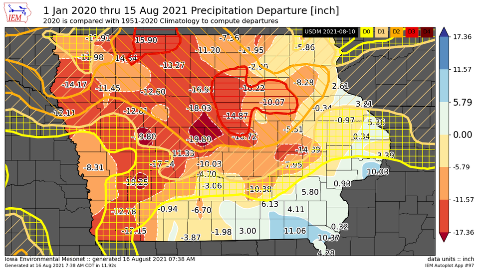
Skyscan Forecast Monday, August 16, 2021 Dan Hicks
Today: Mostly sunny. SE @ 10-15. High 87.
Tonight: Partly cloudy. SE @ 5-10. Low 65.
Tomorrow: Mostly sunny. SE @ 10-15. High 89.
Tuesday Night: Mostly clear. Low 64.
Wednesday: Mostly sunny. High 91.
Thursday: Partly cloudy. High 91.
Yesterday’s high in Atlantic was 84 and the low was 49. This day last year the high was 88 and the low was 57. The all-time record high for today’s date was 105 set in 1936. The record low was 48 set in 1966. Sunrise this morning is at 6:29 a.m., Sunset tonight is at 8:18 p.m., and Sunrise tomorrow is 6:30 a.m.
Today: Sunny, with a high near 83. Light southeast wind becoming south southeast 5 to 10 mph in the morning.
Tonight: Mostly clear, with a low around 57. South southeast wind 5 to 9 mph.
Monday: Sunny, with a high near 83. South wind 6 to 11 mph.
Monday Night: Mostly clear, with a low around 61. South southeast wind 6 to 8 mph.
Tuesday: Sunny, with a high near 86. South wind 6 to 11 mph.
Wednesday: Mostly sunny, with a high near 86.
Saturday’s High in Atlantic was 85. Our Low this morning, 49. Last year on this date, the High in Atlantic was 87, and the Low was 56. The Record High was 103 in 1937, and the Record Low was 40, in 1929.
Today: Mostly sunny. High 83. SE @ 5-10 mph.
Tonight: Fair to P/Cldy. Low 54. Winds light & variable.
Tomorrow: Partly cloudy. High 86. SE @ 5-10 mph.
Monday: P/Cldy. High 86.
Tuesday: P/Cldy to cldy w/scattered showers & tstorms. High around 84.
Friday’s High in Atlantic was 85. Our Low this morning, 49. Last year on this date the High in Atlantic was 90 and the Low was 58. The Record High on this date was 107 in 1936. The Record Low was 45 in 1929.
Today: Isolated showers possible this morning; Otherwise Partly cloudy. High 84. N @ 5-10 mph.
Tonight: Fair to P/Cldy. Low 54.
Tomorrow: Mostly sunny. High around 86. SE @ 5-10 mph.
Sunday: P/Cldy. High 86.
Monday: P/Cldy to cldy w/scattered showers & tstorms. High around 84.
Thursday’s High in Atlantic was 90. Our Low this morning, 61. Last year on this date the High in Atlantic was 91 and the Low was 65. The Record High on this date was 101 in 1913. The Record Low was 39 in 1964.


