
Today: Mostly cloudy w/drizzle possible this morning; P/Cldy this afternoon. High 57. NW @ 15-25.
Tonight: Mostly clear. Low 31. Winds light & variable.
Tomorrow: Mostly sunny. High 62. SW @ 10.
Sunday: P/Cldy. High 51.
Monday: Mo. Cldy. High 45.
Thursday’s High in Atlantic was 49. Our Low this morning, 45. Rainfall in Atlantic, from 7-a.m. Thursday to 7-a.m. today, amounted to .60″. Last year on this date, the High was 45 and the Low was 25. The Record High was 91 in 1937, and the Record Low was 8 in 1895.
(Ames, Iowa) – The latest Iowa Drought Monitor map was released this (Thursday) morning. It shows continued improvement in the drought conditions, statewide. Locally, much of Montgomery, Cass and Adair Counties remain “Abnormally Dry,” while nearly two-thirds of Madison County is Abnormally Dry. Across Interstate 80, most of Audubon County is experiencing the same conditions, while small parts of Guthrie and Dallas Counties range from Abnormally Dry to mostly Moderately Dry.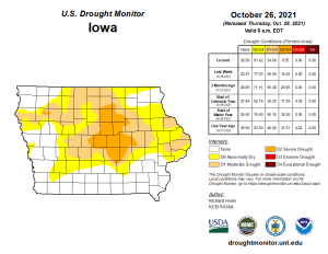
Severe Drought conditions continue to affect parts or all of 10 counties in central/north central Iowa. Across the Midwest, much of the southern and central portions of the Midwest received heavy precipitation, with a band of 2 to locally 4 inches measured from Iowa and northeast Missouri to southern Michigan and northwest Ohio. Areas to the south and north had 0.5 to 2.0 inches, except for a dry spot in southeast Minnesota to central Wisconsin and a dry swath in central Missouri. The northern half of Minnesota received no precipitation.
Today: Light rain. High near 50. N @ 15-25.
Tonight: Light rain ending. Cloudy. Low 42. NW @ 10-20.
Tomorrow: Partly cloudy. High around 57. NW @ 10-20.
Saturday: P/Cldy. High 61.
Sunday: P/Cldy. High 51.
Wednesday’s High in Atlantic was 55. Our Low this morning, 48. 24-hour rainfall in Atlantic, from 7-a.m. Wed. to 7-a.m. today, amounted to 1.35″. Last year on this date, the High was 56 and the Low was 25. The Record High was 83 in 1922, and the Record Low was 2 in 1925.
Today: Cloudy w/a chance of showers and thunderstorms. High 55. SE @ 15-25. (New rainfall amounts between a quarter and half of an inch possible.)
Tonight: Cloudy w/showers and isolated thunderstorms. Low around 45. NE @ 10-20. (New precipitation amounts between three quarters and one inch possible.)
Tomorrow: Cloudy w/rain. High 50. N @ 15-25.
Friday: P/Cldy. High 57. Saturday: P/Cldy. High 61.
Tuesday’s High in Atlantic was 59. Rainfall this morning (up until 6:55-a.m.) was .02″. Our Low was 41. Last year on this date, the High in Atlantic was 40 and the Low was 16. The Record High was 87 in 1922. The Record Low was 9 in 1997.
Today: Areas of fog this morning; Partly cloudy. High near 60. S/SE wind 10-20 mph.
Tonight: P/Cldy to cloudy w/showers late. Low around 49. SE @ 5-10.
Tomorrow: Showers & thunderstorms. High 56. SE @ 10-20.
Thursday: Mostly cloudy w/showers. High 50.
Friday: P/cloudy. High 58.
Monday’s High in Atlantic was 57. Our Low was 35. Last year on this date the High in Atlantic was 32 and the Low was 16. The Record High on this date was 84 in 1956. The Record Low was 14 in 1980.
Today: Becoming partly cloudy. High 56. North wind 10-20 8 mph.
Tonight: Fair to P/Cldy. Low around 34. SE @ 5-10.
Tomorrow: P/Cldy. High 60. S/SE @ 10-20.
Wednesday: Mostly cloudy w/showers & thunderstorms. High 58.
Thursday: Mo. cloudy w/rain. High near 50.
Sunday’s High in Atlantic was 47. Our Low was 42. Rainfall from 7-a.m. Sunday up until 5-a.m. Monday, amounted to 1.43″ at KJAN. Last year on this date, the High in Atlantic was 33 and the Low was 21. The Record High was 85 in 1891 & 1940. The Record Low was 14, in 1892.
Today: Showers and possibly a thunderstorm. High near 50. Breezy, with an east northeast wind 14 to 17 mph, with gusts as high as 25 mph. Chance of precipitation is 90%. New rainfall amounts between 1 and 2 inches possible.
Tonight: Showers and thunderstorms likely, mainly before 10pm. Cloudy, with a low around 36. Breezy, with a north wind 11 to 16 mph, with gusts as high as 25 mph. Chance of precipitation is 60%. New precipitation amounts between a tenth and quarter of an inch, except higher amounts possible in thunderstorms.
Monday: Mostly sunny, with a high near 52. North wind 6 to 8 mph.
Tuesday: Mostly sunny, with a high near 58. Breezy.
Tuesday Night: A 50 percent chance of showers, mainly after 1am. Mostly cloudy, with a low around 48.
Wednesday: Showers. High near 58. Chance of precipitation is 80%.
Saturday’s High in Atlantic was 58. Our Low was 34. (24-hour rainfall ending at 7-a.m. amounted to .41″ at KJAN) Last year on this date the High in Atlantic was 38 and the Low was 22. The Record High on this date was 82 in 1891. The Record Low was 15 in 1999.


