
Today: Cloudy to Partly cloudy. High near 30. NW @ 10-20 mph.
Tonight: P/Cldy. Low 10. Winds light & variable.
Tomorrow: Mostly sunny. High around 40. S @ 10-15.
Monday: P/Cldy. High 38.
Tuesday: P/Cldy. High 42.
Friday’s High in Atlantic was 41. Our Low was 25. Last year on this date the High in Atlantic was 44 and the Low was 27. The Record High on this date was 66 in 1976. The Record Low was -28 in 1983.
(Radio Iowa) – The storm that roared across Iowa Wednesday has been categorized as a derecho. National Weather Service Meteorologist, Brook Hagenhoff, says it’s not exactly the same as the 2020 version. “Technically it would be a serial derecho — which is different than what we saw last year with the August 10th derecho — which is more of what we would call a progressive derecho,” she says. “Kind of the main difference is kind of how it formed.” She says the derecho this week had winds in the upper 80s — but was more spread out across the state. “The derecho that we had last summer in August really had kind of that narrow area that had that very strong 100, 100 plus, 120s even as you got out toward Cedar Rapids. So, that’s kind of the main difference between the two — is that really narrow and very intense band last year — compared to this one which was widespread high-end winds,” according to Hagenhoff.
There were several tornadoes with Wednesday’s storm — and Hagenhoff says the 2020 version also had them. “The one that occurred last August actually did have tornadoes towards the end of the duration of it in the Illinois area. So most of the tornados did not occur in the state of Iowa — they were later on in its lifetime. But, that is something we tend to see in derechos,” she says. Hagenhoff says timing is what makes a storm a derecho when compared to the common thunderstorm. “There’s a requirement for a wind threshold and it has to go for a certain number of miles across the area. Whereas, with a typical thunderstorm that you might have, there’s no requirement for it to last a certain amount of time,” Hagenhoff says.
She says you usually don’t see something like this in December. “This is an extremely rare event — especially for Iowa to have an event of this scale in December,” Hagenhoff says. “We certainly set records as far as temperatures and those temperatures were certainly part of the fuel for the thunderstorms that we had through the evening hours. So, we’re in rare territory with a system like this for sure. The Storm Prediction Center before the event had issued a moderate risk for Iowa — which is a level four out of five. And that was the first time in their history that Iowa had been at a moderate risk.”
Today: Partly cloudy to cloudy. High 40. E @ 5-10 mph.
Tonight: P/Cldy to cldy w/scattered flurries. Low 18. N @ 10-15.
Tomorrow: P/Cldy & breezy w/scattered flurries, early. High 30. NW @ 10-20.
Sunday: P/Cldy. High 39.
Monday: P/Cldy. High 45.
Thursday’s High in Atlantic was 41. Our Low this morning was 17. Last year on this date the High in Atlantic was 36 and the Low was 15. The Record High on this date was 65 in 1939. The Record Low was -18 in 1951.
(Omaha/Valley, NE.) – Officials with the National Weather Service in Nebraska, late Thursday night, issued a report on their preliminary assessment of damage in Pottawattamie County from Wednesday’s tornado event.
A “narrow but strong tornado” that began at around 4:24-p.m. seven-miles southwest of Underwood, was rated an EF-2. It packed peak winds of 120 mph, was 50 yards wide, and traveled for 2.3 miles before ending five-miles southwest of Underwood. The twister tracked along L-34 through Sherwood Country Estates before ending near Juniper Road. The maximum damage was sustained to a home in the Sherwood Estates, where a “Narrow tornado removed the majority of homes roof and damaged other nearby homes as well,” according to the Weather Service.
The second tornado was also an EF-2 that began two-miles east of Underwood and last for about five-minutes before ending two-miles north-northeast of Neola. It packed peak winds of 125 mph, was about 75-yards wide, and tracked for 6.7-miles.The narrow twister began producing damage near Mahogany Road and 290th Street at around 4:31-p.m., Wednesday, and tracked north-northeast into the southeast edge of Neola and caused intermittent damage near Railroad Highway, north of Neola.
The most significant damage was to a home along 290th Street, where the roof was removed and walls were blown out. A nearby garage was moved off its foundation, and approximately 10 mature trees and all uprooted behind the home, with substantial damage to hardwood trees in the front yard.
The narrow nature of the tornado, according to the NWS, was evident in the damage in the path, as nearby barns on the east of the track had low end damage, possibly owing to the significant forward speed of the twister. The tornado was seen briefly by the resident before they sought shelter. A business on the southeast side of Neola also had substantial damage to large metal buildings, at least two of which were destroyed.
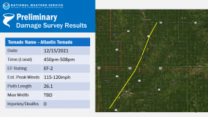
(Des Moines, Iowa) – Officials with the National Weather Service Thursday evening issued a preliminary assessment of the damage caused by a tornado the struck near Atlantic Wednesday evening. The report says an EF-2 tornado (“Atlantic tornado”) traveled approximately 26.1 miles, beginning from southwest of Atlantic at around 4:50-p.m. and continuing to Exira before dissipating near Hamlin 5:08-p.m.
Atlantic Tornado data
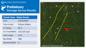
The twister, which was captured on at least three video recordings, had estimated peak wind gusts of between 115-and 120 miles per hour. No injuries or deaths were attributed to the event. The Weather Service says also, they are investigating five tornadoes in Iowa: 4 were EF-2; 1 was an EF-unknown;2 twisters had paths 26-miles long. Additional tornadoes are likely to be confirmed as the data is analyzed. 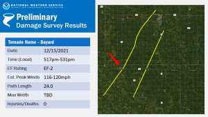
The Montgomery County Emergency Management Agency (EMA) has posted photos of the damage from Wednesday’s storms. Director Brian Hamman said on social media, “Storm damage from last nights storm and wind event seems to be sporadic throughout the county this morning. While there is some considerable tree and out building damage around, widespread damage is limited compared to some of our neighboring counties and communities. If you have damage and would like to post pictures, please do.


(Radio Iowa) – The clean-up process is underway in the north central community of Rudd, as an apparent tornado caused major damage on Wednesday night. Floyd County’s emergency management director Drew Mitchell says the storm went straight through the middle of town. “It went from the south part of town up through the north. It heavily damaged some buildings, knocked down a lot of power lines and trees, stuff like that. It did damage to the water treatment plant. I know the city of Rudd will be without water and power for a few days,” according to Mitchell. Mitchell says despite the destruction there have not been any injuries reported. He says the town is already in a cleanup mode.
“The big thing is is cleanup to begin with, because there is a lot of debris, a lot of power lines down. The power lines will be taken care of by the fire department and the energy company. But cleanup is the big thing, there’s a lot of wood and stuff like that laying around town,” he says. Mitchell says people who want to volunteer as part of the cleanup effort are welcome to come to Rudd, but if you are not helping, they are asking that you stay away.
Anyone willing to help with the cleanup is asked to report to the Rudd Fire Department. The Rudd-Rockford-Marble Rock school building is open for those needing showers, warmth, and meals. A team from the National Weather Service office in LaCrosse will be in Rudd today to survey the storm.
[COUNCIL BLUFFS, IA] – Emergency Management officials in Pottawattamie County today (Thursday) confirmed one tornado touchdown from yesterday’s (Wednesday’s) storms along the I-80 corridor between Council Bluffs and Neola. They will be working today to validate a likely second tornado that occurred in eastern Pottawattamie County and a swath of likely straight-line wind damages in southcentral Pottawattamie County.
The Agency is requesting assistance from the public to help confirm the severity of the events that occurred. Residents or businesses that have experience property damages related to the storm should report them on the EMA’s website at https://pcema-ia.org/. Damage assessments help officials validate and justify any potential assistance programs for those that may have unmet needs and it also contributes to the data needed to support a statewide disaster declaration if the impacts require federal recovery assistance for individuals and local governments.
Pottawattamie County EMA has submitted a request to the Governor’s Office for activation of the Iowa Individual Assistance Program and Disaster Case Management Programs to assist low-income families in their recovery. If approved, more information will be provide through local media, social media, and the emergency management website. The damage assessment survey is an easy to use online interface from any device and also allows you to submit pictures of your damage to help in the overall recovery process.
(Atlantic, Iowa) – Cass County Emergency Management Coordinator Mike Kennon says he has applied for a Disaster Proclamation from the State, and Governor Kim Reynolds is expected to issue a Proclamation for Cass and other counties, sometime today. Kennon said they’re just beginning to assess the damage that spans west/southwest of Atlantic to northeast of town.
Kennon says they had a total of nine semi tractor-trailer rollovers in the County, primarily along Interstate 80. There were no life-threatening injuries reported. He said just because the storm has passed, doesn’t mean there aren’t hazards people should be aware of.
He said power crews are out and about working on downed lines. The tornado sirens in Atlantic went off twice, Wednesday evening. He offered advice to residents in the County, following the storms…
Residents with damage or downed power lines should call the Cass County EMA at 712-254-1500.


