
Today: Becoming partly cloudy. High 18. N/NE @ 15-25. Wind chill as low as -5. (Wind Advisory until 6-a.m.)
Tonight: P/Cldy. Low -7. Winds light & variable.
Tomorrow: P/Cldy. High 28. S/SW @ 10-20.
Monday (Martin Luther King, Jr. Day): P/Cldy. High 34.
Tuesday: P/Cldy. High 38.
Friday’s High in Atlantic was 36. Our Low this morning: 13. We received 2.8″ of snow here at the KJAN studios Friday evening through early today. The rain preceding the snow, and melted snowfall, amount to .52″ of liquid value. Last year on this date, the High in Atlantic was 31 and the Low was 26. The Record High was 61 in 1990. The Record Low was -23 in 1905.
(Radio Iowa) – Forecasters say this formidable winter storm promises to dump up to ten inches of snow across a wide section of Iowa by early this (Friday) evening and the whipping winds could make travel very hazardous. Craig Bargfrede, the Iowa D-O-T’s winter operations administrator, says if you can stay home, do. “We just want to advise the public to be cautious and really watch the weather,” Bargfrede says. “If you really don’t need to travel today, it really looks like one of those days where it might be best to postpone those plans.”
The storm is spreading across Iowa from the northwest to the southeast and the state’s big orange plows are working to keep the roads passable. “We’ve got somewhere around 250 plows out and about,” Bargfrede says. “I just anticipate that number is going to continually increase throughout the day as the storm moves across the state.” Safety is the top priority, he says, for both the plow crews and the motorists, and there may come a point later today at which even the plows will have to be pulled off the roads. “That’s a local call at the garage level — once we get into incidents where visibility really becomes an issue for both our operators and the public,” Bargfrede says. “We watch that very closely and that’s a local call.”
The DOT has 101 maintenance garages statewide that employ more than 1,000 full-time equipment operators, mechanics, and supervisors. Those garages house the agency’s 902 trucks, 42 motor graders, and 32 tow plows. Brine solution has already been spread on many hundreds of miles of Iowa roads, but even with all of the preparation and technology, sometimes the plow crews have to surrender to the elements and pull off the road. “If we do get the winds that they’re forecasting in the 25-30 mile an hour range, that’s going to create some visibility issues for us and for the traveling public as well,” Bargfrede says. “It’s very possible we could see some real impacts on being able to get out there, get at that snow and get it cleaned off.”
While salt has been in short supply in previous years, Bargfrede says Iowa started the winter season with an excellent stockpile of some 240,000 tons. Keep up with road conditions at: 511ia.org
Today: *Winter Weather Advisory*Cloudy w/light rain-freezing rain-sleet and snow this morning becoming all snow. High near 35. E @ 10-20.
Tonight: Snow. Low 12. NE @ 15-30.
Tomorrow: Snow ending in the morning (4-8″ total in the Atlantic area). Becoming P/Cldy. High 20. N @ 10-20.
Sunday: P/Cldy. High 31.
Monday: P/Cldy. High 35.
Thursday’s High in Atlantic was 52. Our Low this morning, 26. Last year on this date the High in Atlantic was 37 and the Low was 28. The Record High was 54 in 1914. The Record Low was -29 in 1957.
(Radio Iowa) -A massive winter storm system will blow into Iowa on Friday which forecasters say may drop nearly a foot of snow on a wide region of the state. Senior meteorologist Rod Donavon, at the National Weather Service office in Johnston, says it’s likely all 99 counties will get at least -some- snowfall, but northern and central Iowa may be in for the worst of it. “Our current forecast right now is in that six-to-ten, seven-to-11 inch range,” Donavon says, “and that’s generally a good portion of our forecast area which includes from Estherville to Mason City and southward, through the Des Moines metro right now looks to be the target area.”
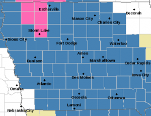
Winter Storm Watch (counties in blue); Winter Storm Warning (counties in pink)
While northern and central Iowa may bear the brunt of the approaching storm, eastern and western Iowa may get three to six inches, with less in the far northeast. It’ll likely snow most of the day, so if you have somewhere to go on Friday, Donavon suggests the going will get tougher as the day wears on, while the Friday evening commute could be a mess. “We are having snow moving into the area from northern Iowa towards the south, getting into the Des Moines metro by mid-morning and by the southern Missouri border by around noon,” Donavon says. “The heaviest accumulations right now are looking like during the afternoon into the early evening hours. We could have some accumulations approaching one inch per hour at times.” 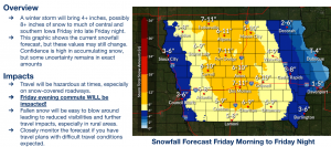
As far as winter storms go, he reminds, it could always be a lot worse. “The fortunate part is, at least the precipitation type is going to be mainly snow with this and no ice,” Donavon says. “It’s going to be generally lighter winds with it, initially. We are going to have some increasing northeast winds later in the event. It’s not going to be blizzard criteria by any means.”
Keep an eye on the changing forecast at weather-dot-gov.
Today: Partly Cloudy. High 47. NW @ 10-15 mph.
Tonight: P/Cldy to Cloudy. Low 27. NE @ 5-10 mph.
Tomorrow: Cldy w/a mix of light rain-snow becoming all snow. High 34. E @ 10-20. *WINTER STORM WATCH*
Saturday: Snow ending in the morning (4-8″ total). Becoming P/Cldy. High near 20.
Sunday: P/Cldy. High 28.
Wednesday’s High in Atlantic was 55. Our Low was 23. Last year on this date the High in Atlantic was 44 and the Low was 32. The Record High on this date was 62 in 1987. The Record Low was -24 in 1916.
Today: Partly Cloudy to Cloudy. High 50. SW winds @ 10-15 mph becoming NW this afternoon.
Tonight: P/Cldy. Low around 30. Variable breeze @ 5-10 mph.
Tomorrow: P/Cldy. High near 42. NW @ 10-15.
Friday: Cldy w/a mix of snow & rain changing to snow. High 35.
Saturday: Light snow ending; P/Cldy to Cldy. High around 20.
Tuesday’s High in Atlantic was 50. Our Low was 22. Last year on this date the High in Atlantic was 45 and the Low was 19. The Record High on this date was 57 in 1961 & 1987. The Record Low was -37 in 1974.
Today: Partly cloudy. High 48. SW @ 15-25.
Tonight: P/Cldy. Low 27. SW @ 5-10.
Tomorrow: P/Cldy. High 45. NW @ 10-15.
Thursday: P/Cldy. High 42.
Friday: Cloudy with a rain-snow mix. High around 35.
Monday’s High in Atlantic was 30. Our Low was 9. Last year on this date the High in Atlantic was 40 and the Low was 19. The Record High on this date was 55 in 1986. The Record Low was -22 in 1892.
(Radio Iowa) – An Iowa State University study finds immigrant entrepreneurs are less likely to choose Iowa as their place of business. I-S-U economics professor John Winters says one main reason Iowa is being avoided is the state’s cold climate, especially during the winter. “Immigrant entrepreneurs are certainly an important part of the U.S. economy and the entrepreneur ecosystem,” Winters says, “and they’re not equally dispersed across the U.S. and to be quite honest, parts the Midwest, Iowa may never have the level of immigrant entrepreneurship that California has.”
Winter says it’s harder for immigrants to imagine running a successful business long-term in a state with such cold weather. He adds, that doesn’t mean Iowa should disregard immigrants who want to open their own businesses. “But it does mean that we have to be especially aware that outsiders are not just going to flock to Iowa,” Winters says, “that maybe we need to think about some of these challenges, and say, ‘Okay, how can we make the state more attractive to people?’”
Winters says Iowa -can- lure in those potential business owners by offering more incentives like expanding outreach and training programs to reach more immigrants in the state.
(byKassidy Arena, Iowa Public Radio)
Today: Partly cloudy. High 28. N @ 10.
Tonight: P/Cldy. Low 15. SE @ 10-15.
Tomorrow: P/Cldy. High 43. SW @ 10-20.
Wednesday: P/Cldy. High 45.
Thursday: Mo. Cldy. High near 40.
Sunday’s High in Atlantic was 25. Our Low was 5. Last year on this date the High in Atlantic was 33 and the Low was 25. The Record High on this date was 59 in 1928. The Record Low was -27 in 1982.
Today: Sunny, with a high near 24. Wind chill values as low as -5. North northwest wind 8 to 13 mph becoming west southwest in the afternoon. Winds could gust as high as 20 mph.
Tonight: Mostly clear, with a steady temperature around 16. Wind chill values as low as 5. Southwest wind 6 to 10 mph becoming north northwest after midnight.
Monday: Sunny, with a high near 26. Wind chill values as low as zero. North wind 5 to 7 mph becoming calm in the afternoon.
Monday Night: Mostly clear, with a low around 12. Wind chill values as low as zero. Light southeast wind becoming south 6 to 11 mph in the evening.
Tuesday: Sunny, with a high near 46. Breezy, with a south southwest wind 11 to 18 mph, with gusts as high as 24 mph.
Wednesday: Sunny, with a high near 47.


