
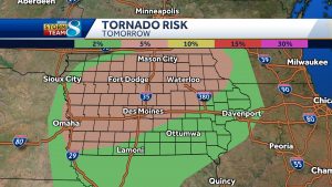
(Madison County, Iowa) – Rural Winterset took a direct hit from a tornado that touched down Saturday evening. Official says the Winterset tornado hit 25-30 homes. Madison County authorities and the Iowa State Patrol are urging the public to please stay away from the area in the coming days.
In Polk County, five homes are considered a total loss south of Pleasant Hill. No major injuries have been reported. There are reports of widespread storm damage throughout the southeast part of Polk County.
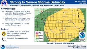
Here is a partial list of the damage caused by tornadic storms and severe weather (Wind/rain/hail) that occurred Saturday afternoon and evening, in our listening area, as compiled by the NWS through storm spotter/emergency management & other reports.
5:12-p.m.: 3 miles N. of Patterson (Madison County)… TORNADO DAMAGE REPORT VIA SPOTTER NETWORK – THERE IS DAMAGE TO A STRUCTURE HERE AS WELL AS EXTENSIVE TREE DAMAGE IN THIS AREA
5:00-p.m.: 1 mile S/SE of Winterset…TORNADO DAMAGE REPORT VIA SPOTTER NETWORK – 12 TREES SNAPPED BRANCHES SNAPPED, PATH A COUPLE HUNDRED YARDS WIDE ON CLARK TOWER ROAD 1/2 MILE NORTH OF ST CHARLES ROAD SOUTH OF WINTERSET.
4:51-p.m.: 2 miles E/SE of Winterset…TORNADO DAMAGE REPORTED VIA SPOTTER NETWORK – TREE DAMAGE AND MINOR DAMAGE TO A HOME AT THIS LOCATION.
4:50-p.m.: 1 mile W/SW of Winterset…TORNADO DAMAGE REPORT VIA SPOTTER NETWORK – BARNS DESTROYED AND HOUSES BADLY DAMAGED IN WINTERSET.
4:48-p.m.: 2 mi. S/SW of Winterset…TORNADO DAMAGE IN WINTERSET TO SHED REPORTED VIA TWITTER.
4:47-p.m.: 2 mi S/SW of Winterset… TORNADO DAMAGE REPORT VIA SPOTTER NETWORK – HOMES AND TREES DAMAGED AND A GARAGE WAS DESTROYED ON 169.
4:35-p.m.: Winterset…TORNADO ONGOING WITH DEBRIS S OF WINTERSET MULTIPLE REPORTS VIA TRAINED SPOTTER AND EMERGENCY MANAGERS.
4:35-p.m.: 2 mi. S of Winterset… TRAINED SPOTTER REPORTS LARGE TORNADO ON THE GROUND SOUTHWEST OF WINTERSET, APPROACHING TIME. DEBRIS VISIBLE. LOCATION ESTIMATED.
4:24-p.m.: 6 miles W/SW of Macksburg (Adair County)…TRAINED SPOTTER REPORT OF A FUNNEL CLOUD.
4:22-p.m.: Orient (Adair County)…TRAINED SPOTTER REPORT OF 2 INCH HAIL (egg size) IN ORIENT.
4:13-p.m.: 2.5″ diameter hail (tennis ball size) 3 mi. E/NE of Orient. (Report of school bus windows broken out)
3:55-p.m.: 1 mi. SE of Cumberland (Cass County)… MULTIPLE STORM CHASER REPORTS OF A FUNNEL CLOUD.
3:55-p.m.: 5 mi. N/NE of Prescott (Adams County)…HAIL REPORT OF 1.75 INCHES (Golf ball size)
3:42-p.m.: 1 mi. SE of Nodaway (Adams County)… 1 1/4″ hail (Quarter to ping-pong ball size)
3:40-p.m.: 1 mi. S. of Corning (Adams County)….MULTIPLE REPORTS OF BRIEF TORNADO TOUCHDOWN.
3:25-p.m.: 2 mi. S. of Walnut (Pott.County)….penny-size hail (3/4″)
3:18-p.m.: 6 mi. N. of Villisca (Montgomery County)…Funnel cloud reported.
3:17-p.m.: 4 mi. E/SE of Essex (Page County)…multiple reports of a funnel cloud.
3:16-p.m.: 1 mi. SE of Emerson…roof damage & a flipped trampoline.
3:15-p.m.: Quarter-size hail 7 mi. E. of Essex.
3:02-p.m.: 1 mi. NE of Emerson (Mills Co.)…Tornado observed by storm spotter.
3:01-p.m.: 1 mi. SE of Emerson (Mills Co.)…Powerlines down and outbuildings destroyed.
There were numerous reports of damage in central and eastern Iowa as the storms moved through and intensified.
Skyscan Forecast Saturday, March 5, 2022 Dan Hicks
Today: Partly cloudy to cloudy. Scattered showers and thunderstorms. S @ 15-25, shifting to the NW. High 65.
Tonight: Showers ending. Mostly cloudy. NW @ 15-25. Low 25.
Sunday: Partly cloudy to cloudy. NW @ 15-25. High 40.
Sunday Night: Mostly cloudy. Chance of rain and snow. N @ 5-10. Low 20.
Monday: Mostly cloudy. Light snow. High 35.
Tuesday: Partly cloudy. High 44.
Yesterday’s high was 60 and the 24-hour low was 28. This day last year the high was 58 and the low was 21. The all-time record high was 74 in 1921 and the record low was -31 in 1960. Sunrise this morning is 6:49 a.m. and sunset tonight is 6:15 p.m.
Today: P/Cloudy & warmer. High 65. S/SE @ 1-25 mph.
Tonight: Mostly cloudy w/rain & possible thunderstorms. Low 50. S @ 10-15.
Tomorrow: P/Cldy to Cldy w/scattered showers & tstrms. High 68. S winds @ 15-25 becoming Northwesterly, late.
Sunday: P/Cldy to cldy. High near 40.
Monday: Cloudy w/a chance of light snow. High around 35.
Thursday’s High in Atlantic was 45. Our Low this morning, 26. Last year on this date the High in Atlantic was 62 and the Low was 27. The Record High on this date was 78 in 1921. The Record Low was -17 in 1978.
Today: P/Cloudy to Cloudy w/a chance of flurries/sprinkles this morning. High 45. NE @ 10-15 mph.
Tonight: P/Cldy. Low 30. E @ 5.
Tomorrow: P/Cldy. High 65. S @ 15-25.
Saturday: P/Cldy to cldy w/showers & thunderstorms. High 65.
Sunday: P/Cldy to Cloudy. High near 40.
Wednesday’s High in Atlantic was 75. Our Low this morning, 29. Last year on this date the High in Atlantic was 66 and the Low was 25. The Record High on this date was 79 in 1983. The Record Low was -11 in 2014.
Today: Partly cloudy. High 72. W/SW @ 10-15 mph.
Tonight: P/Cldy to cloudy. Low 30. N @ 5-10.
Tomorrow: Mostly cloudy. High 45. NE @ 5-10.
Friday: P/Cldy. High around 65.
Saturday: Cloudy w/a chance of showers & thunderstorms. High near 65.
Tuesday’s High in Atlantic was 68. Our Low was 24. Last year on this date the High in Atlantic was 57 and the Low was 24. The Record High on this date was 76 in 1992. The Record Low was -12 in 2014.
(Radio Iowa) – For Iowans who love building snowmen, going snow skiing or sledding, it’s been a lackluster winter as we’ve been lacking in snowfall. State climatologist Justin Glisan says had snow during February, just not very much of it. “Generally, if we look at western Iowa, that was the driest part of the state and anywhere from eight to ten inches below average,” Glisan says. “As we move further east into central and north-central Iowa, anywhere from four to eight inches below average.”
Only the far southeastern tip of the state was above average for snowfall during February. As for temperatures, Glisan says Iowa had a statewide average of 21-degrees in February, which is three degrees colder than normal. While we’ve been enjoying unseasonably warm weather in recent days, Glisan says not to be fooled as there’s still much colder weather ahead in March.
“We do see a signal for below-average temperatures but also an elevated probability of wetter conditions across the state,” Glisan says. “That would be great as we start ramp up the amount of rainfall that we get into the growing season given the drought conditions that we do see across the state.” (You can read February’s weather data for Atlantic on the Weather page at kjan.com)
The climatological winter ended Monday, while astronomical spring arrives on March 20th.
(Atlantic, Iowa) – Weather data for the month of February, 2022 in Atlantic, shows we were warmer than normal. The warmest day was 68, on the last day of the month. The average High of 41 was six degrees above the average. Conversely, the average Low of 9 degrees was six-degrees cooler than the monthly norm. The lowest temp on the 25th, was -7. Precipitation in February (including melted snowfall/ice) amounted to just .11″, which is .85″ less than what we would normally see. Snowfall for the month was just four-tenths of an inch.
During the month of March in Atlantic, the average High is 48 and the average Low is 26. We typically see 2.38 inches of precipitation (Including melted snowfall), in March.
We’ll let you know how the data compared to those stats, when we compile the data next month.
(Radio Iowa) – As we start the month of March, many Iowans are looking ahead to spring. Despite this week’s unseasonably warm weather, a prediction from the Farmers’ Almanac indicates winter will be holding on a little longer. Managing editor Sandi Duncan says we shouldn’t expect to be sporting shorts and t-shirts anytime soon. “Spring officially arrives on the calendar on March 20th, but it looks like it’s going to take a little time for it to warm up,” Duncan says. “However, overall it doesn’t look too extreme. We’re seeing pretty much average temperatures and normal precipitation in your neck of the woods.”
But, Duncan says to keep those boots and snow shovels handy as there is the possibility of a blizzard late in April. “So just when everyone thinks winter is long gone, Mother Nature might throw us all a curve ball,” she says. The Farmers’ Almanac is predicting that once spring-like temperatures do settle in, we are likely to see slightly warmer-than-normal temperatures here in the Midwest.
“It’s going to be a little warmer in the northern half of the country — which includes your area — than it is in the South,” she says. “So some people might refer to this spring as a backward type of spring, but overall the Farmers’ Almanac is showing your area is going to have pretty much average temperatures. Starting off slightly cool, going back and forth and the possibility of a big storm at the end of April.”
Looking ahead, Duncan says much of the upper Midwest will experience a sizzling summer. The Almanac’s forecasts extend out from six to 16 months and they’re based on a formula established two centuries ago. “It was set on a bunch of rules that we’ve altered slightly but we still consider a lot of the rules that our founding editor in 1818, we still follow them,” Duncan says. “They are rules that talk about sunspot activity, tidal action, the Moon, the position of the planets. They apply them to different weather conditions and they’ve been doing a pretty good job for us.”
She says those who follow the publication’s long-range outlooks say they’re 80 to 85% accurate.


