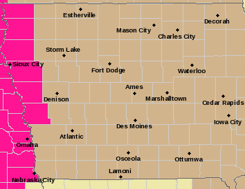
A WIND ADVISORY continues today for Iowa. The Advisory, for gusty northwest winds of 25-to 50-mph, is in effect from 10-a.m. until 7-p.m.
* IMPACTS…Gusty winds could blow around unsecured objects. Tree limbs could be blown down and a few power outages may result.
PRECAUTIONARY/PREPAREDNESS ACTIONS…

Red Flag Warning (Noon-7-pm) for counties in pink; Wind Advisory for counties in tan.
Use extra caution when driving, especially if operating a high profile vehicle. Secure outdoor objects.
In addition, a RED FLAG WARNING for high wind and very low relative humidity, is in effect for Harrison and Monona Counties in our listening area, from Noon today until 9-p.m.
* Impacts…Any fires that ignite may spread rapidly, exhibit extreme behavior and be very difficult to control. Outdoor burning is not recommended.
Monona-and Harrison Counties: A FIRE WEATHER WATCH IS IN EFFECT FROM 12-P.M. (NOON) FRIDAY THROUGH 9-P.M. FRIDAY, FOR WIND AND LOW RELATIVE HUMIDITY.
* Winds…Northwest 20 to 30 mph with gusts up to 50 mph.
* Relative Humidity…As low as 17 percent.
* Impacts…Any fires that ignite may spread rapidly, exhibit extreme behavior and be very difficult to control. Outdoor burning is not recommended.
PRECAUTIONARY/PREPAREDNESS ACTIONS…
A Fire Weather Watch means that critical fire weather conditions are forecast to occur. Listen for later forecasts and possible Red Flag Warnings.
(Radio Iowa) – The new map from the U-S Drought Monitor shows soil conditions in Iowa are improving, slightly, thanks to rain and snow in the past week. The broader picture for the Midwest is worsening, however, with drought conditions expanding over much of the Northern Plains. Meteorologist Dennis Todey, director of the U-S-D-A’s Midwest Climate Hub in Ames, says some crops in the region are already stressed. “We have, obviously, great concerns for winter wheat right now because that area that is in drought and has been in drought extending is much of that winter wheat area from the Central Plains south,” Todey says. “Still a lot can happen but there’s been damage done to it because of drought and some other things.”
The worst of the drought in our state is isolated in far west-central Iowa, and for the region, the driest areas are also to the west. “Most of the major drought areas are just west of the major corn and soybean growing areas but it’s right on the edge,” Todey says, “and the areas that are dry and hot are on the western part of the Corn Belt, so we do have risk there.”
Todey notes much of South Dakota and Nebraska saw less than half of the normal snowfall for the winter. He says there is a big contrast in conditions across the Midwestern crop production areas. “You have a two sides issue with crop production: potential for it being too dry in the far west and the potential for it being too wet — at least as we get started — in the east,” Todey says. “In between is kind of an ‘unknown’ area, Iowa, Illinois, we have some dry areas but we can work with those if we get rainfall.”
The latest map from the U-S Drought Monitor shows roughly 41 Iowa counties are in the category of “abnormally dry,” improving from 45 counties last week. The new map shows 34 counties are in “moderate drought,” versus 36 a week ago. Large sections of Monona and Woodbury counties are listed as “severe drought,” that’s unchanged, while there are around 22 counties where soil moisture levels are considered “normal,” an improvement from 16 counties last week.
Today: Mostly cloudy w/sprinkles or flurries this morning. High 42. NW @ 15-25 mph.
Tonight: Cloudy to P/Cldy. Low 29. NW @ 10.
Tomorrow: P/Cldy. High 52. NW @ 15-25.
Saturday: P/Cldy. High around 50.
Sunday: Mo. cloudy. High near 50.
Wednesday’s High in Atlantic was 38. Our Low this morning, 34. We received a Trace of precipitation (After 7-a.m.), Wednesday. Last year on this date the High in Atlantic was 42 and the Low was 36. The Record High on this date was 83 in 1967. The Record Low was -2 in 1974.
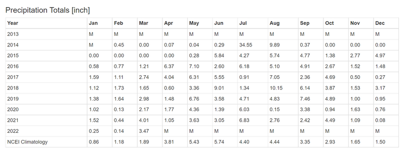
(Lewis, Iowa) – ISU Field Agronomist and Extension Outreach Aaron Saeugling, Wednesday (March 23rd), provided the latest answer to the questions of “How dry are we,” and “Is there a lack of subsoil moisture this spring?” Saeugling says he wants to put into perspective where we are, related to past and current conditions in southwest Iowa. (See the chart below for monthly precipitation dating back to 2014).
Saeugling says “If we look at last year 2020 as a record breaking crop year we notice a few things that spring was abnormally dry with just enough moisture in July to produce a crop. We also notice the October precipitation in 2020m was dramatically lower causing a poor sub soil moisture going into the 2021 crop year.”
“This current crop year,” he says, “We have adequate subsoil moisture based on good October rains in excess of 4 inches. While yes January and February were a record low levels of precipitation the amount so far in march will more than make up for the dry winter.” Saeugling said also, “No knows what the future holds, but we are in a better place now for subsoil moisture than in past springs.”

(Radio Iowa) – As part of Severe Weather Awareness Week, Iowans are urged to take part in this (Wednesday) morning’s statewide tornado drill. Meteorologist Alex Krull, at the National Weather Service in metro Des Moines, says with the number of deadly tornadoes that have already hit Iowa in recent weeks, he hopes people will take this drill very seriously, wherever they are at 10 A-M today. “Get your plan into action and practice executing your plan in the event severe weather strikes — which will likely be happening at some point this spring and summer,” Krull says. “Keep in mind, where are the best places to go in your own home, in your businesses or your school.”
We’ve heard stories from survivors of the March 5th tornadoes that tore through the Winterset area who rode out the powerful storm in their basements, but that’s not always an option for everyone. “If you don’t have a basement available to you, get to the lowest level floor of the building that is available and try to get to the center of it, particularly any room that has multiple interior walls,” Krull says. “A lot of times, it’s going to end up being a bathroom or a closet, something that puts as many walls between you and the outdoors as possible.” The annual statewide tornado drill will take place at the traditional time of 10 o’clock this morning, but the methods for issuing the alert have shifted.
“We will no longer be doing the test tornado warning like we’ve done in years past,” Krull says. “Rather, we’ll use things like social media to get the warning out and other various communications methods that we have with law enforcement and other core partners.” The derecho that hit Iowa on December 15th spawned a record 61 tornadoes, the highest number ever recorded in a single day in Iowa. The storms on March 5th spun off ten tornadoes across the state which claimed seven lives and destroyed or damaged dozens of homes.
“The tornado drill is always an important drill for Iowans and anyone in the Midwest to go through every year, just given the frequency of severe weather,” Krull says. “Given the notable tornado outbreaks we’ve had in the past six months here in the state of Iowa, definitely will have a little more attention to it than it may have had in past years.”
Learn more about today’s drill and this awareness week at www.weather.gov/dmx.
Today: Cloudy & windy, w/light rain mixed w/flurries at times. High 41. NW @ 15-30 w/gusts to near 35.
Tonight: Decreasing cloudiness. Low 32/ NW @ 10-20 w/gusts to near 30 before diminishing late.
Tomorrow: P/Cldy & windy. High 48. NW @ 10-20.
Friday: P/Cldy. High 53.
Saturday: P/Cldy. High near 50.
Tuesday’s High in Atlantic was 46. Our Low this morning, was 34 (at 7-a.m.). We received .37″ rain yesterday (after 7-a.m.) at KJAN. Last year on this date the High in Atlantic was 55 and the Low was 42. The Record High on this date was 86 in 1910. The Record Low was 4 in 1974.
Today: Rain. High nearly steady in the 40’s. N @ 10-20 mph.
Tonight: Light rain mixed with snow late. Low 34. N @ 15-25.
Tomorrow: Light rain/snow, mainly in the morning. Cloudy. High 40. N @ 15-25.
Thursday: Becoming P/Cldy. High 48.
Friday: P/Cldy. High 53.
Monday’s High in Atlantic was 70. Our Low this morning, 45. Rainfall up until 5-a.m. today, was .41″. Last year on this date the High in Atlantic was 49 and the Low was 39. The Record High on this date was 86 in 1910. The Record Low was -6 in 1912.