
Today: A chance of snow before 9am, then a chance of rain and snow between 9am and 10am, then a chance of rain after 10am. Cloudy, with a high near 41. East wind 9 to 11 mph becoming south southeast in the afternoon. Winds could gust as high as 18 mph. Chance of precipitation is 50%. New snow accumulation of less than a half inch possible.
Tonight: Mostly cloudy, then gradually becoming mostly clear, with a low around 27. South southeast wind 5 to 13 mph becoming west northwest after midnight. Winds could gust as high as 22 mph.
Tomorrow (Monday): Sunny, with a high near 49. Windy, with a northwest wind 16 to 21 mph, with gusts as high as 31 mph.
Tuesday: A 30 percent chance of rain after 1pm. Partly sunny, with a high near 47. Breezy.
Wednesday: Showers likely and possibly a thunderstorm before 1pm, then a slight chance of showers. Mostly cloudy, with a high near 63. Breezy. Chance of precipitation is 70%.
Skyscan Forecast Saturday, April 16, 2022 Dan Hicks
Today: Partly cloudy. N @ 10-15. High 51.
Tonight: Increasing clouds. Winds becoming light SE. Low 30.
Sunday: Cloudy. Rain and snow mix in the morning, light rain in the afternoon. ESE @ 10-15. High 43.
Sunday Night: Partly cloudy. WNW @ 5-10. Low 27.
Monday: Partly cloudy. High 54.
Tuesday: Mostly cloudy. Some showers developing. High 60.
Yesterday’s high was 51 and the low was 24. This day last year the high was 49 and the low 40. The all-time record high was 88 set in 1898. The record-low was 19 in 1988. Sunrise this morning is 6:39 a.m. and sunset tonight is 8:01 p.m.
(Radio Iowa) – Residents in Kanawha have returned back to a somewhat normal life after a tornado moved through the area. The Tuesday tornado damaged trees roofs and garages in the city and surrounding area. Police Chief D. J. Martinez says that the cleanup has gone well. Most of the damage was tree limbs that littered the area. “We had a bunch of volunteers come in yesterday and help with everything. We loaded everything up and hauled it out to the north end of town to the trucking location, just to get everything out of the way,” he says. Forecasters at the National Weather Service continually updated the track of the storm and issued warnings once trained spotters assessed the situation. Martinez says that was extremely helpful.
“I think everybody was pretty well informed the night of and they did a good job with everything on Facebook, radio stations, and everything, keeping people aware of what was coming,” Martinez says. “Obviously, we thought it was gonna miss us but it ended up coming back. So I thought everything else went pretty well and afterward everybody was ready to be helpful. Unfortunately, sometimes it’s a little too helpful right at the time of the incident, but the next day it went awesome.”
Martinez says Kanawha residents got help picking up the pieces after the storm from several neighboring communities.
(Radio Iowa) – Preliminary information from the National Weather Service has confirmed eight tornadoes were part of Tuesday night’s storms. The weather service rated two of those tornadoes as EF-2s on the scale which classifies zero as the weakest and five as the strongest. Those were east of Bradgate and the other ran from Palmer to Gilmore City. There was an EF-1 southwest of Rutland, and one in Mason City.
There was an EF-0 in Kanawha. Mitchell and Howard County saw three tornadoes — with two rated EF-1s and the other an EF-0. Many buildings, houses, and trees were damaged — but there were no deaths or injuries reported following Tuesday’s outbreak.
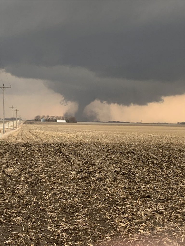
Gilmore City tornado. (photo from NWS)
Today: Partly cloudy. High near 50. NW winds @ 10-20 mph.
Tonight: P/Cldy. Low 25. NW @ 10.
Tomorrow: P/Cldy. High near 50. NW @ 10-15.
Sunday: Mostly cloudy w/a chance of light snow/rain early. High 45.
Monday: P/Cldy. High 54.
Thursday’s High in Atlantic was 53. Our Low this morning was 28. Last year on this date the High in Atlantic was 54 and the Low was 32. The Record High on this date was 84 in 1920. The Record Low was 17 in 1926 & 1962.
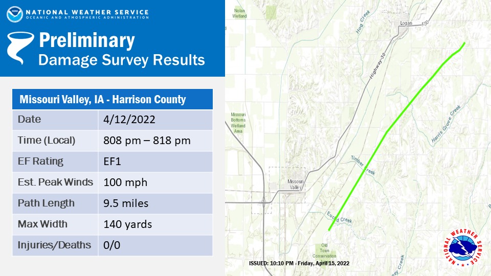
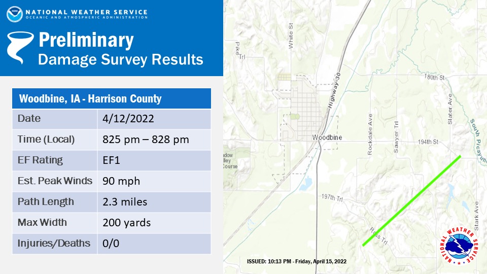
[Updated] (Logan, Iowa) – A storm spotter/first responder was injured and several properties were damaged when severe storms swept through Harrison County, Tuesday. Harrison County Emergency Management coordinator Philip Davis said in a news release, that he found “significant damages” to two residences south of Logan while out assessing the storm damage on Wednesday. He also found “major damage” to a home in the Woodbine area. Trees and agricultural lands also sustained some damage.
Davis said also, a responder who was helping with storm spotting during the storm was injured. The extent of that person’s injuries has not yet been released. The National Weather Service issued a warning for Harrison County around 7:53 p.m. Tuesday. It warned of a line of severe thunderstorms capable of producing a tornado. The NWS has not yet confirmed a tornado touched down in that area. On Thursday, the NWS did say eight confirmed tornadoes took place elsewhere across the State, Tuesday.
The strongest twisters were rated at EF2 outside Gilmore City, in Pocahontas County, and in Humboldt County, near Bradgate. In the northeast part of the state, an EF1 hit southwest of Mason City, and an EF0 was briefly on the ground in Hancock County. Three weaker tornadoes were reported in Mitchell and Howard counties. All but one of the twisters were packing winds in excess of 100-mph.
Harrison County officials want to know if anyone else in the county has damaged property as a result of the storm. Anyone with damage was asked to report it by clicking here or calling Harrison County Communications at 712-644-2244.
Today: Wind Advisory from 7-am until 7-p.m.; Red Flag Warning from Noon until 9-p.m.; P/Cldy to Cldy. W @ 20-35. High 50.
Tonight: P/Cldy to Cldy. Low 30. NW @ 10-15.
Tomorrow: P/Cldy to Cldy. High 48. NW @ 10-20.
Saturday: P/Cldy. High 51.
Sunday: Mo. Cldy w/light rain or snow early. High 47.
Wednesday’s High in Atlantic was 48. Our Low this morning, 28. Last year on this date, the High in Atlantic was 51, and the Low was 26. The Record High for April 14th was 89 in 2003, and the Record Low was 11, in 1907.
(Radio Iowa) – A storm front pushed hazardous weather through the state Tuesday afternoon and evening, spawning hail and damaging winds in some areas. National Weather Service meteorologist Rod Donovan says northern Iowa took the brunt of it. “We did have a couple of tornado confirmations certainly around the Gilmore City area in addition to near Bode and Harvey up in Humboldt County as well, so we will be sending storm survey crews up there today to really determine the damage,” Donovan says. “We have actually had some other potential areas that we could have some minor or isolated tornado touchdowns as well.”
Hail that was a bit larger than two-and-a-half inches in diameter was reported near Gilmore City. There were no reports anyone was injured in Tuesday’s storm. Cool and windy conditions remain in the forecast for the next few days. “Really, overall kind of an unpleasant day Thursday where we’ll have wind gusts in that 40-50 mile range through most of the day,” Donovan says.


