
Today: P/Cldy to Cldy w/scattered afternoon shwrs & tstrms. High 68. SE @ 15-25 mph.
Tonight: Mo. Cldy w/showers & tstrms. Low 52. SE @ 10-15.
Tomorrow: Mostly cloudy w/scattered shwrs & tstrms. High near 70. SE @ 15-25.
Saturday: Mo. Cldy w/showers & tstrms, mainly in the morning. High 62.
Sunday: P/Cldy to Cldy. High near 60.
Wednesday’s High in Atlantic was 77. Our Low this morning was 48. Last year on this date the High in Atlantic was 68 and the Low was 40. The Record High on this date was 94 in 1910. The Record Low was 26 in 1965.
(Washington, D-C) – Extreme heat kills more Americans than any other weather event, but not everyone’s risk is the same. This summer, NOAA (The National Oceanic and Atmospheric Administration) and community scientists will map the hottest parts of 14 U.S. cities (Including Omaha, NE) and counties, and, for the first time, two international cities. Deputy Secretary of Commerce Don Graves says “Extreme heat kills more Americans than any other weather event and has the greatest impact on our nation’s most vulnerable communities. Fortunately, our talented and dedicated researchers and scientists at NOAA are working directly with communities across the country to help them take action to manage extreme heat. As climate change worsens heat waves, this critical information will help bring local and equitable solutions for those facing the greatest threats.”
NOAA Administrator Rick Spinrad, Ph.D said “Our nation faces a climate crisis that has exacerbated inequities for low-income communities and communities of color. NOAA is helping communities measure their hottest places so that they can use this information to inform strategies to reduce the unhealthy and deadly effects of extreme heat and help us build a Climate-Ready Nation.” 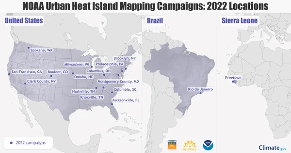
The NOAA Climate Program Office will work with the interagency National Integrated Heat Health Information System (NIHHIS) and CAPA Strategies, LLC to launch new community-led heat mapping campaigns this summer. Local teams will map what are called urban heat islands, areas that can be up to 20 degrees hotter than nearby neighborhoods. The U.S. communities chosen for the program include Boulder, Colorado; Clark County, Nevada, which includes Las Vegas; Columbia, South Carolina; Columbus, Ohio; Jacksonville, Florida; Knoxville and Nashville, Tennessee; Milwaukee, Wisconsin; Montgomery County, Maryland; Omaha, Nebraska; Spokane, Washington; Philadelphia; Brooklyn, New York and San Francisco. In addition, NOAA is working with local groups in Africa and Brazil on international campaigns in Freetown, Sierra Leone and Rio de Janeiro, Brazil.
Learn more, HERE. And, to keep up with the summer 2022 campaigns, subscribe to the Heat Beat Newsletter, check out the NIHHIS website, or follow #UrbanHeatMaps2022 on social media.
Today: P/Cldy. High 72. SE @ 15-25 mph.
Tonight: P/Cldy to Cldy w/showers & tstrms late. Low 56. SE @ 10-15.
Tomorrow: Mostly cloudy w/scattered shwrs & tstrms. High 68. SE @ 15-25.
Friday: Mo. Cldy w/showers. High 70.
Saturday: Mo. Cldy w/shwrs & tstrms, especially in the morning, High 65.
Tuesday’s High in Atlantic was 66. Our Low was 24. Last year on this date the High in Atlantic was 85 and the Low was 47. The Record High on this date was 90 in 1989. The Record Low was 23 in 1950.
(Radio Iowa) – The climate-driving weather system known as La Nina may be sticking around still longer, impacting how Iowa’s weather evolves well past summer. Meteorologist Dennis Todey, director of the U-S-D-A’s Midwest Climate Hub in Ames, says the experts had expected La Nina to fade this spring. “We’ve gone through two years of La Nina, that’s not uncommon,” Todey says. “The initial thoughts were that La Nina was going to weaken this spring and dissipate. It has weakened but it really hasn’t dissipated. It actually has strengthened in certain ways. So, La Nina is still very present and impacting our background issues with the outlooks.”
Todey says the forecasting models for the next several months show a tendency toward above-normal temperatures and a lack of rain. “We did have this area of maybe not being warm in the north central U.S, and in June, July, August, that goes away,” Todey says. “So, much of the western U.S. leans towards above (-normal temperatures) and decreased chances for precipitation — sorry about that — throughout the Plains and even extending into Minnesota, Iowa, Missouri.”
Todey says there is the potential for more heat and expanding drought areas into summer, both in Iowa and across the region. “There were hints this could happen,” he says. “It’s not a guarantee. The probabilities still are not high but it’s definitely something we have to keep an eye on as we go ahead here.” A La Nina event occurs when Pacific Ocean surface temperatures cool, and it influences weather across North America.
Today: **Freeze Warning until 8-a.m.**Mostly sunny. High near 60. NW-SE @ 5-10.
Tonight: Partly cloudy. Low 40. SE @ 5-10.
Tomorrow: P/Cldy. High 68. SE @ 10-15.
Thursday: P/Cldy to Cldy w/scattered showers & thunderstorms. High 68.
Friday: P/Cldy to Cldy w/scattered showers & thunderstorms. High again around 68.
Monday’s High in Atlantic was 51. Our Low this morning (as of 4:55-a.m.), was 24. Last year on this date the High in Atlantic was 89 and the Low was 63. The Record High on this date was 92 in 1987 and 1989. The Record Low was 15 in 1907.
(Radio Iowa) – Grass and field fires remained a big problem this past weekend in western Iowa and bordering states where things remain very dry. Sergeant Bluff fire chief, Anthony Gaul says his firefighters worked several hours responding to calls Saturday, and every area department was busy:
“There were so many fires going on that departments had to travel 20 and 25 miles to help manage incidents because there was nobody else available,” he says. Gaul says the local area damage total from the weekend fires will be more than seven figures as the burn ban in Woodbury County remains in place.
“One community wants to opt-out of it but the amount of dollars that were lost in Woodbury and Plymouth and then across the river and those counties if you add it up is over one million dollars. I know Plymouth County had a piece of apparatus burn up,” Gaul says. Chief Gaul says the strong winds of up to 60 miles an hour at times contributed to the fires.
“One of the fires in Woodbury County was caused by a downed power line which we can’t control that. But others have mentioned hey, we’ve had some rain and yes, we have had some rain but with that wind, it has dried everything out and there is so much out there that’s just ready and able to burn that. We can’t ask enough to stop, not do it,” Gaul says. He says you need to think twice before starting any kind of fire outdoors when conditions are as windy and dry as they have been. Even if you are using a burn barrel.
“We’ve had quite a few incidents caused by burn barrels which can be legal throughout the burn ban but there are requirements that you can’t have more than a one inch opening with a grating,” according to Gaul. He says there are code requirements for burn barrels on the State Fire Marshal’s website.
There are ten active burn bans in the state as of Monday — with all of them along the western edge of the state.
Today: Partly cloudy-to-Cloudy. High around 53. NW @ 20-35 mph.
Tonight: Mostly clear. Low 26. Light & variable breeze. **FREEZE WARNING Tuesday from 1-a.m. until 8-a.m.**
Tuesday: **Freeze warning until 8-a.m.** Mostly Sunny. High around 60. SE @ 10-15.
Wednesday: P/Cldy. High 68.
Thursday: Mo. Cldy w/scattered shwrs & tstrms. High 68.
Sunday’s High in Atlantic was 57. Our Low this morning was 38. Last year on this date the High in Atlantic was 70 and the Low was 39. The Record High on this date was 91 in 2012. The Record Low was 20 in 1934.
Area Counties: Sac-Crawford-Carroll-Audubon-Guthrie-Dallas-Cass-Adair-Madison-Adams-Union-Taylor-Ringgold
256 AM CDT Mon Apr 25 2022
…FREEZE WARNING IN EFFECT FROM 1 AM TO 8 AM CDT TUESDAY…
* WHAT…Sub-freezing temperatures as low 26 to 31 expected.
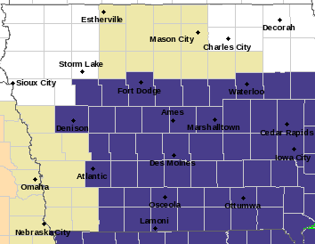
Freeze Warning for Counties in purple
* IMPACTS…Frost and freeze conditions will damage or kill sensitive vegetation and possibly damage unprotected outdoor
plumbing.
PRECAUTIONARY/PREPAREDNESS ACTIONS…
Take steps now to protect tender plants from the cold. To prevent freezing and possible bursting of outdoor water pipes they should be wrapped, drained, or allowed to drip slowly. Those that have in-ground sprinkler systems should drain them and cover above- ground pipes to protect them from freezing.
Special Weather Statement…Gusty Winds Continue this Afternoon…
National Weather Service Des Moines IA
135 PM CDT Sun Apr 24 2022
Sac-Crawford-Carroll-Audubon-Guthrie-Dallas-Cass-Adair-Madison-Adams Counties…
Another day, another round of strong winds for large portions of the Iowa continues this afternoon. As a strong low pressure system north of the area slowly pulls away, winds across much of the NW half of the state will be strong and gusty.
Northern sites have seen largely periodic SW sustained winds to 30 mph and gusts in excess of 40 mph thus far. Winds have been a bit less vigorous down into central Iowa, but remain strong with sustained SW winds 25 to 30 mph and gusts to around 40 mph being seen.
The strong and gusty conditions will last through much of the remainder of the afternoon/evening, easing around and after sunset. Winds will also slowly shift out of the W.
(Has anyone found Toto? lol._
(UPDATED 6:40-a.m., 4/24/22)
PRELIMINARY LOCAL STORM REPORT...SUMMARY
NATIONAL WEATHER SERVICE DES MOINES IA
942 PM CDT SAT APR 23 2022

..TIME...   ...EVENT...      ...CITY LOCATION...     ...LAT.LON...
..DATE...   ....MAG....      ..COUNTY LOCATION..ST.. ...SOURCE....
            ..REMARKS..

0540 PM     TSTM WND GST     2 S MENLO               41.50N 94.40W
04/23/2022  E70 MPH          ADAIR              IA   TRAINED SPOTTER

            SPOTTER REPORT OF 60-70 MPH WIND NEAR MENLO
            AND I80.

0543 PM     TSTM WND GST     1 SW WIOTA              41.39N 94.91W
04/23/2022  E60 MPH          CASS               IA   EMERGENCY MNGR

            ESTIMATE 60MPH WINDS, ZERO VISIBILITY VIA
            EM.

0545 PM     TSTM WND GST     STUART                  41.50N 94.32W
04/23/2022  E70 MPH          ADAIR              IA   FIRE DEPT/RESCUE

            STUART FIRE REPORT OF 60-70 MPH WIND GUSTS
            WITH EXTREME HEAVY RAINFALL AND PEA-SIZED
            HAIL.

0558 PM     TSTM WND GST     DEXTER                  41.52N 94.23W
04/23/2022  E70 MPH          DALLAS             IA   EMERGENCY MNGR

            70 MPH WIND GUST ESTIMATE.

0600 PM     TSTM WND DMG     CALLENDER               42.36N 94.30W
04/23/2022                   WEBSTER            IA   PUBLIC

            PUBLIC REPORT OF A LARGE MORTON BUILDING
            DAMAGED DUE TO WIND IN CALLENDER VIA
            BROADCAST MEDIA.

0604 PM     TSTM WND DMG     1 WNW CALLENDER         42.37N 94.32W
04/23/2022                   WEBSTER            IA   PUBLIC

            DEBRIS ON FAIRBANKS AVE.

0606 PM     TSTM WND DMG     1 NNW HUMBOLDT          42.73N 94.23W
04/23/2022                   HUMBOLDT           IA   PUBLIC

            TREE BRANCH ROUGHLY 6 INCHES IN DIAMETER
            BROKEN OFF.

0608 PM     HAIL             1 E FORT DODGE          42.51N 94.16W
04/23/2022  U0.75 INCH       WEBSTER            IA   PUBLIC

            REPORT FROM MPING: DIME (0.75 IN.).

0610 PM     TSTM WND GST     3 WSW PERRY             41.83N 94.16W
04/23/2022  M58 MPH          DALLAS             IA   AWOS

            AWOS REPORT OF 58 MPH.

0624 PM     FUNNEL CLOUD     2 SW POLK CITY          41.75N 93.73W
04/23/2022                   POLK               IA   PUBLIC

            OBSERVED NEAR SAYLORVILLE LAKE.

0638 PM     TSTM WND GST     2 S AMES                41.99N 93.62W
04/23/2022  M60 MPH          STORY              IA   ASOS

            ASOS REPORT OF 60 MPH WIND GUST.

0655 PM     TSTM WND GST     2 SSE FOREST CITY       43.23N 93.62W
04/23/2022  E59 MPH          HANCOCK            IA   AWOS

            AWOS REPORT OF 59 MPH WIND GUST.

0657 PM     TSTM WND DMG     1 W LELAND              43.33N 93.66W
04/23/2022                   WINNEBAGO          IA   BROADCAST MEDIA

            FARM IMPLEMENT GARAGE DESTROYED. REPORT FROM
            KIMT TV.

0657 PM     TSTM WND DMG     2 S AFTON               40.99N 94.20W
04/23/2022                   UNION              IA   EMERGENCY MNGR

            3 TO 4 INCH DIAMETER TREES AND METAL SHED
            OUTBUILDING DAMAGED 2.5 MILES SOUTH OF
            AFTON.

0702 PM     TORNADO          2 NW SHELDAHL           41.88N 93.72W
04/23/2022                   BOONE              IA   PUBLIC

            2 MILES WEST OF SLATER ON HWY 210 - VIDEO OF
            BARN DESTROYED...VIEWER SAW SMALL TORNADO
            RELAYED VIA BROADCAST MEDIA.

0715 PM     TSTM WND GST     HUBBARD                 42.31N 93.31W
04/23/2022  E62 MPH          HARDIN             IA   NWS EMPLOYEE


0717 PM     TSTM WND GST     2 N WINTERSET           41.36N 94.01W
04/23/2022  E63 MPH          MADISON            IA   PUBLIC

            PERSONAL WEATHER STATION.

0718 PM     TSTM WND DMG     1 SE WINTERSET          41.33N 94.01W
04/23/2022                   MADISON            IA   EMERGENCY MNGR

            ROOF DAMAGE TO WINTERSET FIRE DEPARTMENT.
            TRAILERS ALSO TIPPED AT RACETRACK.

0731 PM     TSTM WND GST     GRAFTON                 43.33N 93.07W
04/23/2022  M49 MPH          WORTH              IA   PUBLIC


0732 PM     TSTM WND GST     4 E ALBION              42.11N 92.92W
04/23/2022  M58 MPH          MARSHALL           IA   ASOS

            CORRECTS PREVIOUS TORNADO REPORT FROM 4 E
            ALBION. ASOS 58 MPH WIND GUST REPORT.

0733 PM     TSTM WND DMG     3 SSW CUMMING           41.44N 93.78W
04/23/2022                   WARREN             IA   EMERGENCY MNGR

            REPORT OF 2 SEMIS BLOWN OFF I-35 AROUND 61MM
            VIA EM.

0745 PM     TSTM WND GST     1 NNW DES MOINES        41.59N 93.63W
04/23/2022  E60 MPH          POLK               IA   BROADCAST MEDIA

            ALSO 1/2 INCH DIAMETER HAIL.

0800 PM     TSTM WND DMG     2 SSW AMES              42.00N 93.64W
04/23/2022                   STORY              IA   BROADCAST MEDIA

            MULTIPLE TREE LIMBS BROKEN DOWN VIA
            BROADCAST.

0825 PM     TSTM WND GST     4 E ALBION              42.11N 92.92W
04/23/2022  M59 MPH          MARSHALL           IA   ASOS

            MARSHALLTOWN AIRPORT ASOS.

0509 AM     HAIL             GLENWOOD                41.05N 95.75W
04/23/2022  E1.75 INCH       MILLS              IA   PUBLIC

            DELAYED REPORT RELAYED BY BROADCAST MEDIA.
            TIME BASED ON RADAR.
0115 PM     NON-TSTM WND GST 2 W RED OAK             41.01N 95.26W
04/23/2022  M61 MPH          MONTGOMERY         IA   AWOS
1135 AM     NON-TSTM WND GST 5 S HARLAN              41.58N 95.34W
04/23/2022  M58 MPH          SHELBY             IA   AWOS
1005 AM     NON-TSTM WND GST 2 W RED OAK             41.01N 95.26W
04/23/2022  M64 MPH          MONTGOMERY         IA   AWOS
0610 AM     HAIL             ELK HORN                41.59N 95.06W
04/23/2022  M1.75 INCH       SHELBY             IA   BROADCAST MEDIA

            TIME ESTIMATED BASED ON RADAR.
0555 AM     HAIL             WALNUT                  41.48N 95.22W
04/23/2022  M1.00 INCH       POTTAWATTAMIE      IA   TRAINED SPOTTER

            SPOTTER CALLED WFO DMX REPORTING 1" HAIL IN
            WALNUT.
0519 AM     HAIL             4 ESE COUNCIL BLUFFS    41.21N 95.79W
04/23/2022  E0.50 INCH       POTTAWATTAMIE      IA   PUBLIC

            REPORT FROM MPING: HALF-INCH (0.50 IN.).

0510 AM     HAIL             GLENWOOD                41.05N 95.74W
04/23/2022  M1.00 INCH       MILLS              IA   PUBLIC

            TIME ESTIMATED FROM RADAR.


