
(Atlantic, Iowa) – Weather data for the month of April, 2022 in Atlantic, shows we were slightly cooler than normal, at 59 degrees (normally 62). The warmest days were on the 11th (84 degrees) and the 22nd (80 degrees). The average Low of 32 was about 5 degrees below normal for the month. The coldest morning was on the 1st, at 15 degrees.
Precipitation in April (including melted snowfall/ice) amounted to 3.24-inches, which was about two-tenths of an inch below normal. We also had a couple of days with pea-size hail (12th and 29th).
During the month of May in Atlantic, the average High is 73 and the average Low is 49. We typically see 4.32 inches of precipitation (Including melted snowfall). We’ll let you know how the data compared to those stats, when we compile the data next month.
Today: Cloudy, then gradually becoming mostly sunny, with a high near 57. Windy, with a west northwest wind 18 to 21 mph, with gusts as high as 30 mph.
Tonight: Partly cloudy, with a low around 37. North wind 5 to 13 mph.
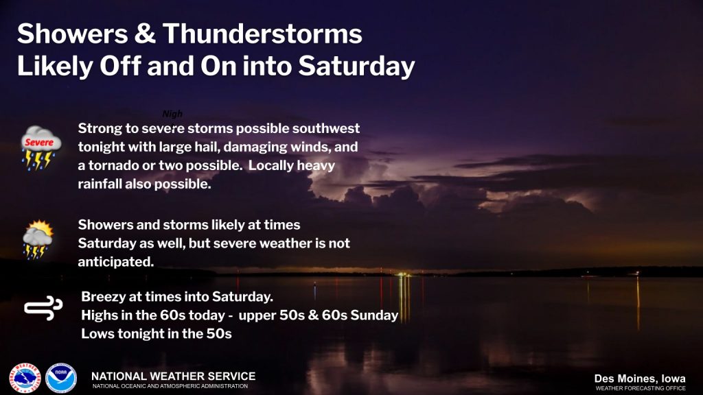
Monday: Showers likely, with thunderstorms also possible after 4pm. Mostly cloudy, with a high near 52. East northeast wind 5 to 15 mph, with gusts as high as 23 mph. Chance of precipitation is 70%. New rainfall amounts between a quarter and half of an inch possible.
Monday Night: Showers and possibly a thunderstorm. Low around 42. Breezy, with a northeast wind 14 to 16 mph, with gusts as high as 26 mph. Chance of precipitation is 100%. New rainfall amounts between three quarters and one inch possible.
Tuesday: A 20 percent chance of showers before 1pm. Mostly cloudy, with a high near 57. North northeast wind around 15 mph, with gusts as high as 24 mph.
Wednesday: A 20 percent chance of showers after 1pm. Partly sunny, with a high near 60.
Saturday’s High in Atlantic was 54. Our Low this morning, 42. We received .05″ rain yesterday (after 7-a.m.). Last year on this date, the High was 87 and the Low was 39. The Record High was 90 in 1965, and the Record Low was 17, in 1909.
Skyscan Forecast Saturday, April 30, 2022 Austin Romer
Today: Light rain in the morning. Cloudy. Cooling temperatures through the day. SW @ 25. High 57.
Tonight: Overcast w/ slight chance of rain. W @ 25. Low 45.
Sunday: Overcast in the morning, then slight clearing through the day. NW @ 20. High 58.
Sunday Night: Partly cloudy. NNW @ 5-15. Low 37.
Monday: Cloudy. Rain showers. NE @ 15. High 52.
Tuesday: Light rain likely in the morning. NE @ 15. High 56.
Yesterday’s high was 65 and the low was 54. This day last year the high was 81 and the low was 39. The all-time record high was 92 set in 1926 and the record low was 19 in 1958. Sunrise today is at 6:19 a.m. and sunset tonight is 8:16 p.m. We picked up .95″ of an inch of rain at the KJAN studios in the past 24 hour period.
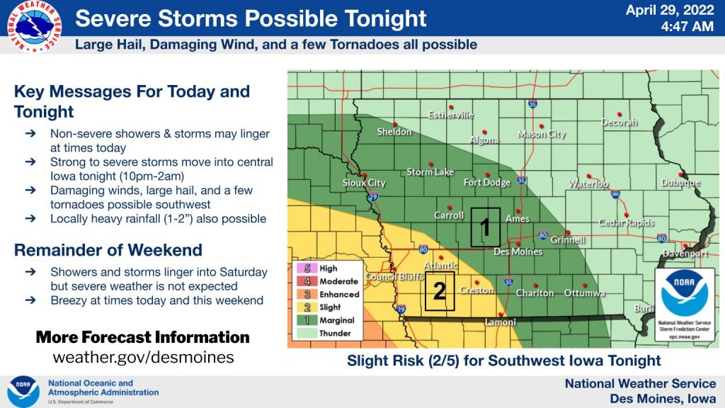
Severe Thunderstorm Warning
National Weather Service Omaha/Valley Nebraska
826 PM CDT Fri Apr 29 2022
The National Weather Service in Omaha has issued a
* Severe Thunderstorm Warning for…
Northwestern Mills County in southwestern Iowa…
Southwestern Pottawattamie County in southwestern Iowa…
Sarpy County in east central Nebraska…
Douglas County in east central Nebraska…
Northeastern Cass County in southeastern Nebraska…
* Until 930 PM CDT.
* At 825 PM CDT, a severe thunderstorm was located over Louisville,
or 20 miles south of Omaha, moving northeast at 30 mph.
HAZARD…70 mph wind gusts and half dollar size hail.
SOURCE…Radar indicated.
IMPACT…Hail damage to vehicles is expected. Expect considerable
tree damage. Wind damage is also likely to mobile homes,
roofs, and outbuildings.
* This severe thunderstorm will be near…
Cedar Creek around 835 PM CDT.
Springfield around 840 PM CDT.
Other locations in the path of this severe thunderstorm include
Omaha, Papillion, Offutt AFB, Bellevue, La Vista, Ralston, Council
Bluffs and Underwood.
This includes the following highways…
Interstate 29 between mile markers 35 and 63.
Interstate 80 in Iowa between mile markers 1 and 17.
Interstate 80 in Nebraska between mile markers 432 and 454.
PRECAUTIONARY/PREPAREDNESS ACTIONS…
For your protection move to an interior room on the lowest floor of a
building.
Torrential rainfall is occurring with this storm, and may lead to
flash flooding. Do not drive your vehicle through flooded roadways.
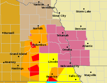
SEVERE THUNDERSTORM WATCH OUTLINE UPDATE FOR WS 161
NWS STORM PREDICTION CENTER NORMAN OK 830 PM CDT FRI APR 29 2022
SEVERE THUNDERSTORM WATCH 161 IS IN EFFECT UNTIL 400 AM CDT FOR THE FOLLOWING LOCATIONS: IOWA COUNTIES INCLUDED ARE ADAIR ADAMS CASS CLARKE DECATUR MADISON RINGGOLD TAYLOR UNION. 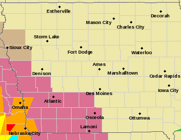
* Primary threats include…
SUMMARY…A band of severe thunderstorms is expected to cross the
watch area from west-east this evening, offering severe gusts,
sporadic large hail, with a tornado also possible embedded in the
complex.
The severe thunderstorm watch area is approximately along and 50
statute miles east and west of a line from 50 miles southwest of
Knob Noster MO to 60 miles north northwest of Lamoni IA.
PRECAUTIONARY/PREPAREDNESS ACTIONS…
REMEMBER…A Severe Thunderstorm Watch means conditions are favorable for severe thunderstorms in and close to the watch area. Persons in these areas should be on the lookout for threatening weather conditions and listen for later statements and possible warnings. Severe thunderstorms can and occasionally do produce tornadoes.
SEVERE THUNDERSTORM WATCH OUTLINE UPDATE FOR WS 160
NWS STORM PREDICTION CENTER NORMAN OK
720 PM CDT FRI APR 29 2022
SEVERE THUNDERSTORM WATCH 160 IS IN EFFECT UNTIL 1200 AM CDT
FOR THE FOLLOWING LOCATIONS: .IOWA COUNTIES INCLUDED ARE
FREMONT HARRISON MILLS MONTGOMERY PAGE POTTAWATTAMIE SHELBY
* Primary threats include…
Severe Thunderstorm Watch for counties in mauve color
SUMMARY…An organizing complex of thunderstorms is expected to pose predominantly a severe-wind threat as it moves eastward through the watch area this evening. Isolated large hail and a tornado also may occur.
The severe thunderstorm watch area is approximately along and 45 statute miles north and south of a line from 15 miles south of Columbus NE to 35 miles north northeast of Shenandoah IA.
PRECAUTIONARY/PREPAREDNESS ACTIONS…
REMEMBER…A Severe Thunderstorm Watch means conditions are favorable for severe thunderstorms in and close to the watch area. Persons in these areas should be on the lookout for threatening weather conditions and listen for later statements and possible warnings. Severe thunderstorms can and occasionally do produce tornadoes.
Today: Mostly cloudy w/showers ending this morning; P/Cldy to Cldy this afternoon, w/scattered shwrs & tstrms. High 70. SE @ 15-25 mph.
Tonight: Mo. Cldy w/shwrs & tstrms. Low 52. S @ 10-15 mph.
Tomorrow: Shwrs & tstrms ending, becoming P/Cldy. High 58. W @ 20-35 mph.
Sunday: P/Cldy to Cldy. High around 60.
Monday: Mo. Cldy w/shwrs & tstrms. High near 62.
Thursday’s High in Atlantic was 74. Our Low was 50. Rainfall overnight through early this morning amounted to .8″ (8/10 of an inch). Last year on this date the High in Atlantic was 78 and the Low was 35. The Record High was 93 in 1987, and the Record Low was 22, in 1958.


