
(Radio Iowa) -The National Oceanic Atmospheric Administration predicts dry conditions will continue for western Iowa and expand eastward. Meteorologist Adam Hartman authored the report. “Much of what I leaned on was the below normal soil moisture anomalies that are currently in place across the state along with the long term dryness. In addition to, we are in La Niña,” he says.
La Niña weather conditions are a climate pattern that produces drier days. U-S Ag Department meteorologist, Brad Rippey, says the weather’s impact on crops depends largely on the timing of the heat waves.
“Especially since crops are going in a little bit late this year. And so if heat and dryness expand at the wrong time, for example, corn and soybeans that could have an effect on some of the summer crops,” Rippey says. Much of the northwest region of the state is already experiencing abnormally dry conditions. Woodbury, Plymouth and Monona counties face severe drought.
Today: Patchy fog between 7am and 9am. Otherwise cloudy, w/light rain or drizzle this morning. High near 60. North wind 10 to 20 mph.
Tonight: Becoming partly cloudy. Low around 42. North wind 5 to 10 mph, with gusts as high as 20 mph.
Tomorrow: Areas of morning fog; P/Cldy. High 74. N-S @ 5-10.
Saturday: P/Cldy & breezy. High 84.
Sunday: P/Cldy & windy. High near 90.
Memorial Day: Scattered showers are possible. High in the 80’s.
Wednesday’s High in Atlantic was 54.Rainfall amounted to .64″. Our Low this morning, 50. Last year on this date, the High in Atlantic was 84 and the Low was 54. The Record High was 100 in 2018. The Record Low was 30 in 1901.
Today: Cloudy w/areas of fog this morning; Light rain or drizzle. High 58. NE @ 10-20.
Tonight: Cldy w/areas of fog, light rain/drizzle. Low 48. N @ 10-15.
Tomorrow: Light rain/drizzle ending in the morning; Mo. Cldy. High 62. N @ 10-20.
Friday: P/Cldy. High 76.
Saturday: P/Cldy. High 86.
Tuesday’s High in Atlantic was 57. Our Low was 49. We received .98″ rain Tuesday into early this morning. Last year on this date the High in Atlantic was 82 and the Low was 51. The Record High on this date was 98 in 1967. The Record Low was 30 in 1925.
Today: Mostly cloudy w/scattered light rain. High near 60. E/NE @ 10-20.
Tonight: Cloudy w/rain & some thundershowers. Low 50. NE @ 10-15.
Tomorrow: Cloudy w/light rain. High 56. N/NE @ 10-20.
Thursday: A chance of showers early. Mo. Cloudy. High 64.
Friday: P/Cldy. High 76.
Monday’s High in Atlantic was 64. Our Low was 48. Last year on this date the High in Atlantic was 83 and the Low was 67. The Record High on this date was 101 in 1939. The Record Low was 33 in 1924.
Today: Mostly cloudy. High 66. E @ 10-15. (UPDATED)
Tonight: Mo. Cldy w/showers late. Low 48. E @ 5-10.
Tomorrow: Isolated showers/thunderstorms. High 56. E @ 10-20.
Wednesday: Mo. Cloudy w/a chance of rain. High 59.
Thursday: P/Cldy. High 68.
Sunday’s High in Atlantic was 67. Our Low was 37. Last year on this date the High in Atlantic was 82 and the Low was 65. The Record High on this date was 97 in 1939. The Record Low was 26 in 1963
Today: Widespread frost, mainly before 7am. Otherwise, sunny, with a high near 66. Light west wind becoming northwest 9 to 14 mph in the morning. Winds could gust as high as 22 mph.
Tonight: Increasing clouds, with a low around 43. North wind around 6 mph becoming calm in the evening.
Monday: A 30 percent chance of showers, mainly between 1pm and 2pm. Cloudy, with a high near 62. East southeast wind 5 to 11 mph, with gusts as high as 21 mph. New precipitation amounts of less than a tenth of an inch possible.
Monday Night: A 40 percent chance of showers. Cloudy, with a low around 47. East wind 6 to 9 mph. New precipitation amounts of less than a tenth of an inch possible.
Tuesday: Showers likely. Mostly cloudy, with a high near 59. East northeast wind 7 to 14 mph, with gusts as high as 25 mph. Chance of precipitation is 60%. New precipitation amounts between a quarter and half of an inch possible.
Tuesday Night: Showers likely, with thunderstorms also possible after 1am. Cloudy, with a low around 48. Chance of precipitation is 60%. New rainfall amounts between a quarter and half of an inch possible.
Wednesday: A 40 percent chance of showers. Mostly cloudy, with a high near 60.
Saturday’s High in Atlantic was 60. Our Low this morning, 31. Last year on this date the High in Atlantic was 78 and the Low was 65. The Record High on this date was 98 in 1925. The Record Low was 28 in 1895 & 1963.
Area Counties: Monona-Harrison-Shelby-Audubon-Crawford and Carroll…
…FROST ADVISORY IN EFFECT FROM 1 AM TO 9 AM CDT SUNDAY…
* WHAT…Temperatures as low as 35 will result in frost formation.
* IMPACTS…Frost could kill sensitive outdoor vegetation if left uncovered. 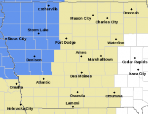
PRECAUTIONARY/PREPAREDNESS ACTIONS…
Take steps now to protect tender plants from the cold.
Today: P/Cldy to Cldy. High 59. N @ 10-15.
Tonight: Gradual clearing overnight. Low 39. NW @ 5-10.
Tomorrow: Clear to P/Cldy. High 66. NW @ 10.
Monday: Cloudy w/a chance of afternoon rain. High 59. E @ 10.
Tuesday: A chance of showers. High 59.
Friday’s High in Atlantic was 72. Our Low this morning, 47. Last year on this date the High in Atlantic was 80 and the Low was 66. The Record High on this date was 97 in 1939. The Record Low was 27 in 1895.
Today: Cloudy w/any rain ending; Becoming Partly cloudy. High 66. NW @ 10-20.
Tonight: P/Cldy to Cldy. Low 44. N @ 5-10.
Tomorrow: Mo.Cldy w/scattered light rain. High 58. N @ 10-15.
Sunday: Mo. Sunny. High 68.
Monday: P/Cldy to Cldy w/a chance of afternoon shwrs & tstrms. High near 70.
Thursday’s High in Atlantic was 88. We received just a few sprinkles before sunrise today. Our Low this morning was 56. Last year on this date the High in Atlantic was 74 and the Low was 62. The Record High on this date was 95 in 1925. The Record Low was 26 in 1894.


