
Today: Cloudy to Partly Cloudy. High 77. SE-NW @ 5-10 mph.
Tonight: P/Cldy. Low 60.
Tomorrow: P/Cldy to Cldy w/scattered afternoon showers & thunderstorms. High 83. S @ 10-15.
Sunday: P/Cldy to Cldy w/scattered shwrs & tstrms. High 85.
Monday: P/Cldy. High around 95.
Thursday’s High in Atlantic was 77. Our Low was 57. Rainfall at KJAN amounted to .15″. Last year on this date the High in Atlantic was 96 and the Low was 68. The Record High on this date was 104 in 1933. The Record Low was 40 in 1966.
Today: Areas of fog this morning; Partly sunny w/scattered showers & thunderstorms developing late. High 79. S @ 5-10 mph.
Tonight: Mostly cloudy w/scattered shwrs & tstorms. Low 58. S-N @ 5-10.
Tomorrow: Shwrs & tstrms ending in the morning; P/Cldy. High 77. N @ 10.
Saturday: P/Cldy w/scattered late day shwrs & tstrms possible. High near 83.
Sunday: P/Cldy to Cldy w/scatt. shwrs & tstrms. High near 85.
Wednesday’s High in Atlantic was 78. Our Low this morning, 52. Last year on this date, the High in Atlantic was 94 and the Low was 64. The Record High on this date was 101 in 1985, and the Record Low was 38, in 1915.
A KJAN listener in the area of Norway Center in Cass County, sent KJAN these photos following a Tuesday night storm event. They speculated an EF-1 tornado may have caused the damage, due to “the way the wind was surging with the hail the cops out here or shredded beans were uprooted. Crops are a total loss.” The property owner is working to remove the tree and clean-up from the storm.

Photos submitted


PRELIMINARY LOCAL STORM REPORT...SUMMARY
NATIONAL WEATHER SERVICE DES MOINES IA & VALLEY NEBRASKA
226 AM CDT WED JUN 8 2022

..TIME...   ...EVENT...      ...CITY LOCATION...     ...LAT.LON...
..DATE...   ....MAG....      ..COUNTY LOCATION..ST.. ...SOURCE....
            ..REMARKS..

0753 PM     TSTM WND DMG     1 NW CRESTON            41.07N 94.38W
06/07/2022                   UNION              IA   PUBLIC

            REPORT FROM MPING: TREES UPROOTED OR
            SNAPPED; ROOF BLOWN OFF.

0754 PM     TSTM WND DMG     2 NNE CRESTON           41.08N 94.36W
06/07/2022                   UNION              IA   EMERGENCY MNGR

            FARM OUTBUILDINGS DAMAGED ON CHERRY STREET
            RD. TIME ESTIMATED.

0800 PM     TSTM WND GST     2 S CRESTON             41.03N 94.36W
06/07/2022  M68 MPH          UNION              IA   AWOS

            REPORTED AT 8 PM AND 805 PM.

0800 PM     TSTM WND DMG     CRESTON                 41.06N 94.36W
06/07/2022                   UNION              IA   EMERGENCY MNGR

            TREES, SHEDS, AND POWER LINES DOWN.

0807 PM     HAIL             1 S AFTON               41.01N 94.20W
06/07/2022  M0.88 INCH       UNION              IA   TRAINED SPOTTER

            ALONG WITH STRONG WINDS.

0827 PM     TSTM WND DMG     6 N GRAND RIVER         40.90N 93.97W
06/07/2022                   CLARKE             IA   EMERGENCY MNGR

            TIN BLOWN OFF OF OUTBUILDING ON R15. TIME
            ESTIMATED.

0645 PM     TSTM WND GST     1 W ATLANTIC            41.40N 95.03W
06/07/2022  M67 MPH          CASS               IA   AWOS


0652 PM     HAIL             1 ENE ATLANTIC          41.40N 95.00W
06/07/2022  E0.50 INCH       CASS               IA   TRAINED SPOTTER

            ALSO STRONG WIND AND HEAVY RAIN.

0729 PM     HAIL             FONTANELLE              41.29N 94.56W
06/07/2022  M1.00 INCH       ADAIR              IA   EMERGENCY MNGR


0733 PM     TSTM WND DMG     7 W ORIENT              41.20N 94.55W
06/07/2022                   ADAIR              IA   EMERGENCY MNGR

            ROOF BLOWN OFF OF MACHINE SHED. TIME
            ESTIMATED.


0742 PM     HAIL             ORIENT                  41.20N 94.42W
06/07/2022  E0.88 INCH       ADAIR              IA   AMATEUR RADIO

            NICKEL HAIL NORTH OF ORIENT.

0745 PM     TSTM WND DMG     ORIENT                  41.20N 94.42W
06/07/2022                   ADAIR              IA   EMERGENCY MNGR

            LARGE TREE DOWN ON HOUSE. TIME ESTIMATED.

0748 PM     HAIL             3 W ORIENT              41.20N 94.48W
06/07/2022  M1.00 INCH       ADAIR              IA   TRAINED SPOTTER

            NICKEL TO QUARTER SIZED HAIL.
0617 PM     TSTM WND DMG     3 WNW AVOCA             41.50N 95.38W
06/07/2022                   POTTAWATTAMIE      IA   PUBLIC

            DELAYED REPORT. SEMI BLOWN OVER. TIME
            ESTIMATED FROM RADAR.
0946 PM     TSTM WND GST     5 WSW HEPBURN           40.83N 95.11W
06/07/2022  E60 MPH          PAGE               IA   FIRE DEPT/RESCUE

            1 FT TREE LIMB DOWN. TIME ESTIMATED FROM
            RADAR.
0824 PM     HAIL             4 ESE COUNCIL BLUFFS    41.21N 95.80W
06/07/2022  M1.50 INCH       POTTAWATTAMIE      IA   PUBLIC
0815 PM     HAIL             1 NNE COUNCIL BLUFFS    41.26N 95.85W
06/07/2022  M1.00 INCH       POTTAWATTAMIE      IA   EMERGENCY MNGR
Today: Partly cloudy. High near 70. NW @ 10-15 mph.
Tonight: Fair to P/Cldy. Low 50.
Tomorrow: P/Cldy to Cldy w/scattered showers & thunderstorms. High 78. SE @ 10.
Friday: Showers ending; Becoming P/Cldy. High 78.
Saturday: P/Cldy to Cldy w/scatt. Afternoon shwrs & tstrms. High 79.
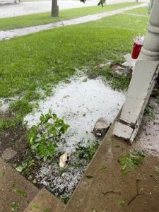
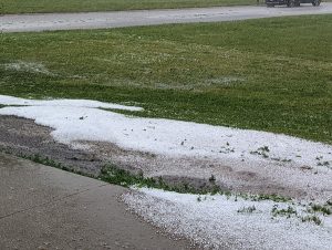
Tuesday’s High in Atlantic was 82. Our Low was 60. Last year on this date the High in Atlantic was 91 and the Low was 64. The Record High on this date was 102 in 1985. The Record Low was 38 in 1930. We received 1.63 inches of rain at the KJAN Studios in Atlantic. Pea-to-dime size hail covered the ground in Atlantic, Tuesday evening. In addition there was heavy rain and straight-line winds.
Here are some photos of Tuesday’s storm and related damage in Atlantic. If you have photos to share, please e-mail them to kjannews@metc.net,

Atlantic Parks & Rec Photo
Courtesy Miranda Olson

pics by News Director Ric Hanson
Today: Areas of fog this morning; P/Cldy w/scattered showers & thunderstorms, mainly this afternoon. High 78. S @ 5-10 mph.
Tonight: Mo. Cldy w/scatt. Shwrs & tstrms. Low 59. S-N @ 5-10.
Tomorrow: Showers ending ealry; P/Cldy. High 76. N 10-15.
Thursday: P/Cldy w/shwrs & tstrms late. High 79.
Friday: Showers ending; P/Cldy. High 76.
Monday’s High in Atlantic was 78. Our Low was 57. Last year on this date the High in Atlantic was 90 and the Low was 62. The Record High on this date was 98 in 1934/2011. The Record Low was 36 in 1894.
Today: P/Cldy to Cldy w/isolated morning showers. High 76. N wind @ 5-10 mph.
Tonight: P/Cldy. Low around 53. N @ 5-10.
Tuesday: P/Cldy to Cldy w/scattered afternoon showers & thunderstorms. High 78. SE 10.
Wednesday: Showers early, then P/Cldy. High 76.
Thursday: P/Cldy w/a chance of late afternoon showers. High 79.
Sunday’s High in Atlantic was 83. Our Low 61. Last year on this date, the High in Atlantic was 84 and the Low was 66. The Record HIgh was 103 in 1933. The Record Low was 32 in 1894.
(Sunday’s rainfall amount will be added before 6-p.m.)


