
Today: Cloudy through mid morning, then gradual clearing, with a high near 80. North wind 5 to 10 mph.
Tonight: Clear, with a low around 55. Mostly calm winds.
Tomorrow: Sunny, with a high near 84. SW winds around 5-10 mph.
Tom. Night: Clear, with a low around 58.
Sunday: Sunny, with a high near 76.
Sunday Night: Mostly clear, with a low around 48.
Labor Day: Mostly sunny, with a high near 76.
Tuesday: Sunny, with a high near 78.
Thursday’s High in Atlantic was 96 degrees. Our Low this morning was 67. We received 1.25″ of rain at the KJAN studios Thursday evening/overnight. Last year on this date the high was 85 and the low was 57. The record high for August 30th in Atlantic was 101 degrees in 1947. The record low was 33 in 1893. Sunrise today: 6:43-a.m., and Sunset is at 7:57-p.m..
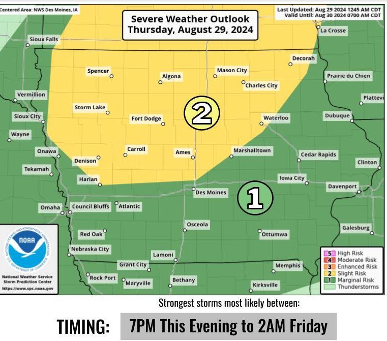
(Radio Iowa) – Forecasters say Iowa should see ideal weather for the Labor Day weekend, but things may get steamy and stormy before the holiday arrives. Meteorologist Craig Cogil, at the National Weather Service, says thundershowers moved across upper Iowa this (Thursday) morning. “We’ve seen some storms develop in northern Iowa, and they’re currently moving into southern Minnesota, as we see warmer and more humid air move back into the state,” Cogil says, “and it’s certainly going to push highs up to around 90 this afternoon with the humid conditions continuing.”
NWS graphic
Wide areas of the state may see heat indices back into triple digits today, but Cogil says another round of showers tonight should bring cooler air with it. “We’re going to see a cold front move down through the state into the overnight period, with showers and thunderstorms developing this evening,” Cogil says. “There may be the potential for some severe storms right now, looking at the main threat from damaging winds and large hail.” Once tonight’s storms are past, Cogil says it should be smooth sailing into Labor Day, as well as into next week. “It looks like the holiday weekend should be rather pleasant, particularly Sunday and Monday,” Cogil says, “with highs mainly in the 70s and very little humidity and no threat of precipitation.”
Waterloo and Davenport both set record high temperatures of 98 degrees earlier this week, with some communities seeing heat indices as high as 117.
Today: Mostly sunny w/a 30% chance of showers & thunderstorms, mainly after 3pm. High near 91. South winds 10-20 mph. New rainfall amounts of less than a tenth of an inch, except higher amounts possible in thunderstorms.
Tonight: Showers & thunderstorms. Some of the storms could produce heavy rainfall. Low around 64. New rainfall amounts between three quarters and one inch possible.
Friday: Cloudy through mid morning, then gradual clearing, with a high near 80. N/NW winds 5-10.
Friday Night: Mostly clear, with a low around 55.
Saturday: Sunny, with a high near 83.
Sunday: Sunny, with a high near 78.
Labor Day: Mostly sunny, with a high near 75.
Wednesday’s High in Atlantic was 89 degrees. The Low was 67. Last year on this date the high was 86 and the low was 56. The record high for August 29th in Atlantic was 102 degrees in 1894. The record low was 34 in 1893. Sunrise today: 6:42-a.m., and Sunset is at 7:58-p.m..
Today: Patchy fog this morning; Otherwise sunny. High near 89. S/SE winds 5-10 mph.
Tonight: Mostly clear, with a low around 71.
Tomorrow: A chance of showers & thunderstorms, otherwise mostly sunny. High 89. S winds @ 10-20 mph.
Tom. Night: Showers and possibly a thunderstorm. Low around 62.
Friday: Mostly sunny, with a high near 80.
Friday Night: Mostly clear, with a low around 55.
Saturday: Sunny, with a high near 83.
Sunday: Sunny, with a high near 75.
Tuesday’s high was 91 degrees. Our low this morning was 67. Last year on this date the high was 84 and the low was 55. The record high for August 28th in Atlantic was 100 degrees, set in 1984. The record low was 35 in 1967. Sunrise today: 6:41-a.m., and Sunset is at 8-p.m..
Today: Partly sunny w/a 30% chance of showers & thunderstorms. High near 90. N/NW winds @ 5-10 mph this morning becoming W/SW this afternoon.
Tonight: Mostly cloudy w/a 30% chance of showers & thunderstorms. Low around 66.
Wednesday: A slight chance of showers & thunderstorms through mid-day, otherwise mostly sunny. High near 88. SE winds 5-10.
Wed. Night: Partly cloudy w/a slight chance of showers & thunderstorms late. Low around 69.
Thursday: Partly sunny w//a 60% chance of showers & thunderstorms. High near 87.
Thu. Night: A 50% chance of showers and thunderstorms. Low around 60.
Friday: Sunny, with a high near 80.
Monday’s high was 98 degrees. Our low this morning was 71. We received .01″ rain before sunrise. Last year on this date the high was 82 and the low was 54. The record high for August 27th in Atlantic was 101 degrees, set in 1913, 1936 & 1937. The record low was 36, set in 1906. Sunrise today: 6:40. Sunset is at 8:01.
(Radio Iowa) – Some Iowa school districts will dismiss classes early today (Monday) because of the extreme heat, as high temperatures are forecast in the upper 90s, with heat indices climbing into triple digits. While we’re less than a month from the first day of fall, meteorologist Cory Martin, at the National Weather Service, says this type of heat is usually associated with the dog days of summer. “Today, during the afternoon hours, we’ll be looking at heat index values peaking between 105 to 110,” Martin says. “Some areas may jump a little over 110, with the highest readings likely to be in eastern Iowa today.”
The entire state is under a heat advisory, while excessive heat warnings are posted for wide sections of eastern and western Iowa. “So it’s really across the whole state, when you’re looking at the different advisories and warnings, those both key in on different thresholds, but really the end result to everyone today is — it’s going to feel hot and humid outside,” Martin says. “It’s important to take your precautions, to limit your time outside, and make sure you’re adequately hydrated, and really just limit your time exposed to the heat.” 
Tuesday will only be slightly cooler, with highs in the 80s and 90s statewide, though Martin says we should see a cool-down soon. “As we go through the week, we’re still looking at temperatures gradually tailing off,” Martin says, “with highs back to around 80 degrees across much of the state as we head into the weekend.”
The forecast for Labor Day weekend calls for more seasonal temperatures and dry conditions.
Today: Sunny and hot. High near 98. HEAT ADVISORY from 1-until 8-p.m. Heat index values as high as 110. Southwest wind 5 to 10 mph.
Tonight: Mostly clear, with a low around 72. South southwest wind 5 to 10 mph.
Tuesday: Mostly sunny, with a high near 91. West southwest wind 5 to 10 mph.
Tue. Night: Partly cloudy w/a slight chance of showers and thunderstorms. Low around 67.
Wednesday: Mostly sunny, with a high near 89.
Wed. Night: Partly cloudy w/a slight chance of showers and thunderstorms late. Low around 69.
Thursday: A 40% chance of showers & thunderstorms, otherwise mostly sunny, with a high near 87.
Sunday’s high was 95 degrees. Our low this morning, 69. Last year on this date the high was 83 and the low was 55. The record high for August 26th in Atlantic is 100 degrees, set in 1936, and the record low is 39, set in 1904. Sunrise today: 6:38. Sunset is at 8:03.
Today: HEAT ADVISORY in effect from 1-until 8-p.m. Sunny, with a high near 95. Heat index values as high as 109. South winds around 10 mph.
Tonight: Mostly clear, with a low around 73. South wind 5 to 10 mph.
Tomorrow: HEAT ADVISORY FROM 1-UNTIL 8-P.M.; Sunny and hot, with a high near 97. Heat index values as high as 106. South southwest winds 5 to 10 mph.
Tom. Night: Mostly clear, with a low around 72. South southwest winds 5 to 10 mph.
Tuesday: Mostly sunny, with a high near 92.
Tue. Night: A 20% chance of showers and thunderstorms; Partly cloudy, with a low around 68.
Wednesday: Mostly sunny, with a high near 91.
Saturday’s High in Atlantic was 87. The Low was 65. Last year on this date, the High in Atlantic was 92, and the Low was 69. The Record High in Atlantic on Aug. 25th, was 105 in 1936. The Record Low was 37, in 1908. Sunrise – 6:38. Sunset – 8:06.
Friday’s high was 80 degrees, our low this morning is 62. We received .10″ of rain last night (around 1-a.m. today) in Atlantic. Last year on this date the high was 98 and the low 72. The record high for August 24th in Atlantic is 105 degrees set in 1936 and the record low is 37 set in 1908.
Today: Mostly cloudy w/a slight chance of showers between 10am and 3pm. High near 79. South wind 5 to 10 mph.
Tonight: Mo. cloudy w/a slight chance of showers & thunderstorms. Low around 65. Southeast wind 5 to 10 mph.
Saturday: Partly sunny w/a 30% chance of showers & thunderstorms through mid-day. High near 86. S/SE @ 10-20 mph.
Saturday Night: Partly cloudy, with a low around 73.
Sunday: Sunny, with a high near 96.
Monday: Mostly sunny, with a high near 94.
Mon. Night: A slight chance of showers & thunderstorms after midnight. Low around 67.
Tuesday: Mostly sunny, with a high near 88.
Thursday’s high was 77 degrees, our low this morning is 59. Last year on this date the high was 96 and the low 77. The record high for August 23 in Atlantic is 99 degrees set in 1894 and the record low is 36 set in 1891.


