
A Freeze Warning continues for the entire State of Iowa until 9-a.m. Today (Saturday)
* WHAT…Sub-freezing temperatures, as low as the mid 20s north.
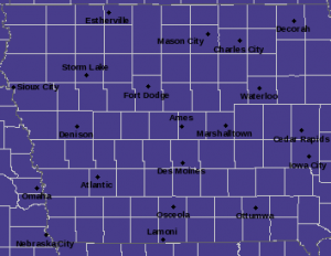
Freeze Warning for counties in purple, until 9-a.m. (10/8/22)
* WHEN…Until 9 AM CDT this morning.
* IMPACTS…Frost and freeze conditions will kill crops, other sensitive vegetation and possibly damage unprotected outdoor plumbing.
Today: **Freeze Warning until 9-a.m.** Areas of fog this morning, otherwise mostly sunny. High 63. SW Winds @ 10 mph.
Tonight: Mostly clear. Low 38. SW Winds @ 5-10.
Tomorrow: Mostly sunny. High 72. SW @ 10-15 mph.
Monday (Columbus Day): P/Cldy. High 74.
Tuesday: P/Cldy. High 76.
Friday’s High in Atlantic was 56. Our Low this morning was 22. Last year on this date the High in Atlantic was 84 and the Low was 51. The Record High on this date was 93 in 1893. The Record Low was 19 in 1908 & 2000.
Today: Partly Cloudy. High 56. N Winds @ 10 mph.
Tonight: Mostly clear. Low 25. Winds light & variable.
Tomorrow: Mostly sunny. High 63. SW @ 10 mph.
Sunday: P/Cldy. High 72.
Monday (Columbus Day): P/Cldy. High near 70.
Thursday’s High in Atlantic was 69. Our Low this morning was 39. Last year on this date the High in Atlantic was 76 and the Low was 51. The Record High on this date was 88 in 1938. The Record Low was 16 in 1952 & 2012.
The National Weather Service has issued a Freeze Warning for most Iowa, effective Saturday (Oct. 8th) from 1-am until 9-a.m.
* WHAT…Sub-freezing temperatures as low as 28 expected.
* IMPACTS…Frost and freeze conditions will kill sensitive vegetation and possibly damage unprotected outdoor plumbing.
PRECAUTIONARY/PREPAREDNESS ACTIONS…
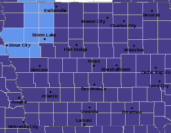
Freeze Warning for Counties in purple; Frost Advisory for Counties in light blue.
Take steps now to protect tender plants from the cold. To prevent freezing and possible bursting of outdoor water pipes they should be wrapped, drained, or allowed to drip slowly. Those that have in-ground sprinkler systems should drain them and cover above-ground pipes to protect them from freezing.
Today: Partly Cloudy. High 68. N Winds @ 15-25 mph.
Tonight: P/Cldy. Low 35. N @ 5-10.
Tomorrow: P/Cldy. High 56. N @ 10 mph.
Saturday: Mostly sunny. High 65.
Sunday: P/Cldy. High near 70.
Wednesday’s High in Atlantic was 75. Our Low this morning was 43. Last year on this date the High in Atlantic was 76 and the Low was 53. The Record High on this date was 91 in 1963 & 1997. The Record Low was 15 in 2012.
(Radio Iowa) – The La Nina weather system often brings Iowa and the Midwest an above-normal helping of precipitation, but even though the pattern is expected to stick around for yet another winter, we’re still suffering with drought. Doug Kluck, the climate services director for the Central Region of the National Weather Service, says there would normally be a lot more rainfall, especially in the Missouri River basin. Kluck says, “It is possible that La Nina can contribute in a positive manner more usable precipitation for the basin.” The expected amount of precip simply hasn’t been materializing, he says, and it’s unclear whether that will change with the snowpack in the winter season ahead.
“The last two years have been La Nina and those last two years have been something like 88 and 90% of normal snowpack, where we would hope that La Nina would give us over 100%,” Kluck says, “but that didn’t happen.” Kluck says this situation is what adds to so much climate prediction uncertainty. “It tells you the fickleness, to be honest, of using La Nina only as a forecast tool for that neck of the woods,” he says.
The National Climate Prediction Center is forecasting this La Nina will fade away by early spring. The latest report from the U-S Drought Monitor shows 80 percent of Iowa is either abnormally dry or in some level of drought.
Today: Light rain ending this morning; Partly Cloudy to Cloudy. High 74. Wind NW @ 10 mph.
Tonight: P/Cldy. Low 50. Wind light & variable.
Tomorrow: P/Cldy. High 68. N @ 10-20 mph.
Friday: P/Cldy. High 58.
Saturday: P/Cldy. High 66.
Tuesday’s High in Atlantic was 83. The Low was 50. We received light rain early this morning, amounting to slightly more than a Trace. Last year on this date, the High in Atlantic was 77 and the Low was 47. The Record High was 93 in 1963. The Record Low was 22 in 2012.
Today: Partly Cloudy. High near 80. Wind S @ 10-20 mph.
Tonight: P/Cldy to Cldy w/scattered showers late. Low 56. S @ 5-10 mph.
Tomorrow: A chance of showers in the morning; Becoming P/Cldy. High 75. NW @ 10 mph.
Thursday: P/Cldy. High 66.
Friday: /Cldy. High 58.
Monday’s High in Atlantic was 79. The Low was 43. Last year on this date, the High in Atlantic was 81 and the Low,43. The Record High was 90 in 1938 & 2005. The Record Low was 20 in 1968.
(Radio Iowa) – All of the counties across the northern third of Iowa wrapped up the month as the 10th driest September on record, which is significant given that’s over one-and-a-half centuries of record keeping. Most of that region was two-and-a-half to three-and-a-half inches below normal for rainfall. State climatologist Justin Glisan says it’s no surprise the summer ended up being extremely dry overall. (Atlantic’s Weather data can be found here: https://www.kjan.com/index.php/2022/10/september-oct-2022-weather-data-for-atlantic/)
“We averaged a little over 10 inches across the state and that’s about three-and-a-half inches below normal,” Glisan says, “so, 58th warmest summer out of 150 years of records but also the 29th driest summer in 150 years of records, so that’s where we really saw drought expand.” The statewide average temperature for September was 65-degrees, which is about one-and-a-half degrees warmer than normal. He says the summer overall wrapped up just slightly warmer than normal, too.
“The average temperature was about 73 degrees and that’s a little over a degree above normal, so a warmer summer but not a scorcher,” Glisan says. “We, of course, had heat waves and we also had some cooler periods, so those somewhat balanced out when we look at temperature.” He notes Iowa is heading into October in much the same condition as last year, following an exceptionally dry summer.
“Luckily, October of 2021 was the eighth-wettest on record, which really staved off expansion and degradation of drought,” Glisan says, “but we need months and months of above-average precipitation as we move through fall, winter and 2023 to really start recovering, namely northwestern Iowa, but also much of southern Iowa.” While we can rejoice that there have been relatively few tornadoes in Iowa this year, and even few severe storms, but that carries a dual result.
“We’re tailing off in terms of severe weather events,” Glisan says. “June and July are the hotspots, even into May. Lack of severe weather translates into lack of thunderstorms and that translates into a lack of rainfall and hence, we saw drought conditions expand across much of the state.” Iowa is two-and-a-half years into the drought now and Glisan says if we go back to early 2020, some areas of northwest Iowa have a significant precipitation deficit of 15- to 25-inches below normal for rainfall.
(Radio Iowa) – As dry conditions persist, particularly in northwest Iowa, many city water systems have asked customers to voluntarily conserve water. Todd Uhl, the public works director in Sheldon, says there’s no emergency yet, but things are going slowly in the wrong direction and mandatory water restrictions may be on the horizon. “As this drought continues, if we don’t get a good recharge this fall, winter, next spring — we will be on mandatory restrictions next spring for sure,” Uhl says. “I’m not saying we wouldn’t switch to them sometime this winter, but obviously restrictions going into this time of year don’t mean as much as they do in times when outside watering is more of a thing.”
There’s plenty of water in both of Sheldon’s deep wells, but Uhl says the quality of water in those deep wells have lower quality water. The community’s supply of high quality water comes from a series of shallow wells along the Floyd River and northwest of Sheldon and Uhl says the water levels in THOSE wells are dropping. “The static level, which is the level of the amount of water in the well when the pumps aren’t running, we’re seeing those levels decline. They’v been declining slowly this whole summer — not to the level where we’ve slammed on the panic button yet, but it’s going to be a concern if we don’t get recharge this winter or next spring, Sheldon will be on mandatory restrictions next summer,” Uhl says. “We will not be able to sustain another year of this.”
If the water situation doesn’t improve, Uhl describes what “mandatory restrictions” would look like. “No use of water for non-essential purposes, so basically you can use water for human consumption and that’s it,” Uhl says, “There’ll be no lawn watering. They’ll be no garden watering. There’ll be no flower garden watering. There’ll be no washing of cars. We’ll try not to limit the use of car washes and stuff that are doing it for a living, but we’re going to have to have people cut back.”
But the VOLUNTARY restrictions are what are in place in Sheldon today. The Lewis & Clark Regional Water System is due to connect in Sheldon by 2024 or, perhaps, at the end of 2023 and Uhl says that would also help the situation.


