
Today: Mostly cloudy w/light rain & isolate thundershowers. Temps falling from a daytime high of around 61 into the 50’s this afternoon. NW @ 15-25 mph.
Tonight: Rain ending; Partly cloudy. Low 34. Winds becoming calm overnight.
Tomorrow: P/Cldy. High 58. NW @ 15-25.
Wednesday: P/Cldy. High 58.
Thursday: Mo. Cldy. High 56.
Sunday’s High in Atlantic beat the record of 81 set in 1901 & 1991, when the thermometer hit 84. Our Low was 58. Last year on this date the High in Atlantic was 47 and the Low was 40. The Record High on this date was 82 in 1891. The Record Low was 15 in 1999.
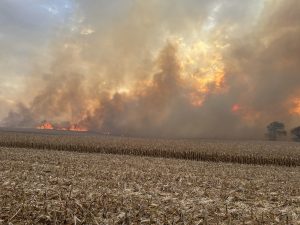
(Harrison and Montgomery Counties) – Multiple agencies battle field fires in western Iowa, Sunday afternoon. The flames were spread quickly by strong winds, and resulted in the voluntary evacuation of some residents, especially in Montgomery County, where a fire quickly went out of control and spread some three-to four miles before being brought under control at around 8:30-p.m.
Emergency Management Coordinator Brian Hamman reports “The Montgomery County Communications Center received multiple 9-1-1 calls at 4:47pm reporting a small ditch fire in the area of Highway 34 x A Ave. Mutual aid was requested immediately prior to any fire units arriving on scene due to wind conditions. Once fire crews arrived on scene, the fire grew rapidly and spread quickly north to adjoining fields. Several homes in the area were evacuated by law enforcement and mutual aid was again requested from numerous area fire departments.
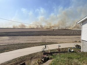
Brian Hamman photo

Brian Hamman photo

Harrison County fire
Harrison County fire
A combine fire Saturday afternoon spread to stand field of corn, with Shelby and Harrison counties had fire departments respond to a combine fire that spread to standing corn. Shelby, Portsmouth and Persia were all assisted by some much appreciated tractor operators with discs.

Shelby County Emergency Svcs. Assoc. photo
Montgomery County Field Fire assisting agencies:
Today: **WIND ADVISORY from this afternoon until 2-a.m. Monday**; Sunny, with a high near 84. S @ 15-30 mph. Winds could gust to near 50 mph.
Tonight: A chance of showers and thunderstorms. Low around 54. S @ 25-35 w/gusts to near 50, decreasing after midnight.
Monday: A 50 percent chance of showers. High 62 w/the temperature falling during the afternoon. Winds W @ 15-25 mph.
Monday Night: Skies clearing overnight. Low around 34.
Tuesday: Sunny. High near 56. N/NW wind 10-20 mph.
Tuesday Night: Mostly clear, with a low around 31.
Wednesday: Mostly sunny, with a high near 58.
Saturday’s High in Atlantic was 82. The Low was 57. Last year on this date (Oct. 23), the High in Atlantic was 58 and the Low was 34. The Record High for Oct. 23rd in Atlantic, was 81 in 1901 & 1991. The Record Low was 13, in 1895.
Sac-Crawford-Carroll-Audubon-Guthrie-Dallas-Cass-Adair-Madison-Adams-Union-Taylor-Ringgold-Monona-Harrison-Shelby-Pottawattamie-Mills-Montgomery-Fremont- Page Counties… Sun Oct 23 2022 …
WIND ADVISORY IN EFFECT FROM THIS AFTERNOON UNTIL 2 AM MONDAY...
* WHAT…South winds 25 to 30 mph with gusts up to 50 mph expected.
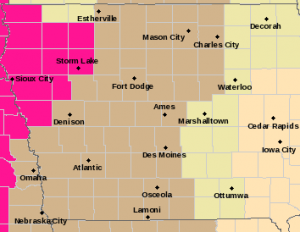
Wind Advisory for counties in light brown; Red Flag Warning for counties in pink.
* IMPACTS…Gusty winds could blow around unsecured objects. Tree limbs could be blown down and a few power outages may result.
* ADDITIONAL DETAILS…The period of strongest winds will transition from southwest Iowa this afternoon into central and northern Iowa this evening. Strong winds and dry conditions will result in an enhanced fire danger, especially west of Highway 169.
PRECAUTIONARY/PREPAREDNESS ACTIONS… Use extra caution when driving, especially if operating a high profile vehicle. Secure outdoor objects.
Today: Sunny, with a high near 79. S @ 20-25 mph.
Tonight: Mostly clear, with a low around 61. SE @ 10-20.
Tomorrow: Partly cloudy to cloudy. High 84. Severe storms are possible. Winds S @ 15-30 w/gusts to around 45 possible.
Monday: A 75 % chance of showers & thunderstorms. High 66. SW @ 15-30.
Tuesday: P/Cldy w/a chance of rain. High 57. NW @ 10.
Thursday’s High in Atlantic was 78. Our Low was 33. Last year on this date the High in Atlantic was 53 and the Low was 28. The Record High on this date was 87 in 1899. The Record Low was 15 in 1976.
(Radio Iowa) – This year’s Iowa-based World Food Prize is being awarded to a NASA climate scientist. Cynthia Rosenzweig is a senior researcher at the Goddard Institute for Space Studies. She studies the effects of climate change on food systems. During her acceptance speech last night in Des Moines,
Rosenzweig said climate change mitigation needs to address greenhouse gas emissions from food systems. She also highlighted the urgency to act against climate change. The award comes with a 250-thousand dollar prize. Rosenzweig says she’ll use that money to establish a fund for global workshops on climate change and food through the Columbia Climate School.
DES MOINES, Iowa — The drought conditions are continuing to worsen across Iowa. According to the latest report from the Iowa Drought Monitor released Thursday, for the period ending Oct. 18th, the entire state remains in a drought, but 84% is now moderately dry. That number was just 57% last week. About 7% of the state remains extremely dry.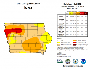
Today: Sunny, with a high near 77. Southwest wind 5 to 8 mph.
Tonight: Mostly clear, with a low around 45. Calm wind becoming south 5 to 7 mph after midnight.
Tomorrow: Sunny, with a high near 79. Breezy, with a south wind 8 to 17 mph, with gusts as high as 24 mph.
Sunday: Mostly sunny, with a high near 82. Windy.
Sunday Night: A chance of showers and thunderstorms. Partly cloudy, with a low around 54. Windy. Chance of precipitation is 40%.
Monday: A 50 percent chance of showers. Mostly cloudy, with a high near 65. Breezy.
Thursday’s High in Atlantic was 69. Our Low was 25. Last year on this date the High in Atlantic was 49 and the Low was 28. The Record High on this date was 87 in 1947. The Record Low was 13 in 1930.
(Radio Iowa) – Recent events like Hurricane Ian hitting the southeastern U-S and the derechos in the Midwest have prompted some to ask if it’s better to bury power and communication lines underground versus hanging them above ground on utility poles. Rod Pritchard, a spokesman for I-T-C Midwest, says it really comes down to dollars. “The cost of that is a main determining factor,” Pritchard says. “Compared with overhead line construction, the cost of underground transmission is five to ten times more, and so we view it as being cost prohibitive.”
Pritchard says environmental factors are also a consideration, as putting cables underground disturbs a lot of soil. “Although the underground line is much better protected in terms of storm events, when you do have an outage with underground line, it can take a lot of work to find that as well as to fix that problem,” he says, “whereas overhead lines are much easier to repair if there is an outage.”

Cedar Rapids post-derecho in August of 2020 (Trees Forever photo)
I-T-C owns and operates high-voltage transmission infrastructure in Iowa and six other states, with its ITC Midwest subsidiary based out of Cedar Rapids. Across its system, I-T-C has 16-thousand circuit miles of transmission line.
Today: Partly cloudy. High 66. W/SW @ 10-20 mph.
Tonight: Partly cloudy. Low 43. SW @ 5-10.
Tomorrow: P/Cldy. High 75. SW @ 10-20.
Saturday: P/Cldy. High 78.
Sunday: P/Cldy. High near 80.
Wednesday’s High in Atlantic was 55. Our Low was 12 (that tied the old, 24-hour Low of 12 set in Oct. 19, 1972). Last year on this date the High in Atlantic was 64 and the Low was 41. The Record High on this date was 87 in 1947 & 2003. The Record Low for Oct. 20th, was 14 in 1960.


