
Today: Partly to mostly sunny & cold. High 29. Winds NW @ 15-25.
Tonight: Fair to partly cloudy. Low 10. Wind light & variable.
Tomorrow: P/Cldy. High 44. S @ 10-20.
Friday: P/Cldy. High 57.
Saturday: P/Cldy & cooler. High near 30.
Tuesday’s High in Atlantic was 36. Our Low this morning, 15. We received .2” of snow at the KJAN studios, Tuesday, and .05” rain/freezing rain. Last year on this date the High in Atlantic was 60 and the Low was 30. The Record High on this date was 66 in 1922. The Record Low was -10 in 1964.
Harrison-Shelby-Pottawattamie-Mills-Sac-Crawford-Carroll-Audubon Counties…
219 AM CST Tue Nov 29 2022
…A WINTER WEATHER ADVISORY REMAINS IN EFFECT FROM 6 AM THIS MORNING TO 6 PM CST THIS EVENING…
Harrison-Shelby-Pottawattamie-Mills Counties: Mixed precipitation expected. Total snow accumulations of up to one inch and ice accumulations of up to 5 hundredths of an inch. Winds gusting as high as 40 mph.
Sac-Crawford-Carroll-Audubon Counties: Mixed precipitation expected. Total snow accumulations of up to 3 inches is expected with highest amounts near the Minnesota border. Areas with ice accumulations will see mainly a light glazing. Winds are expected to gust as high as 35 mph. 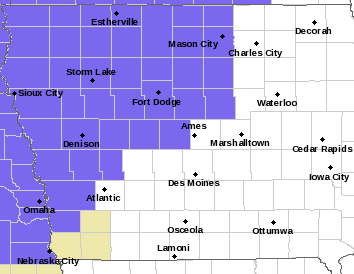
* IMPACTS…Plan on slippery road conditions. The hazardous conditions could impact the morning or evening commute.
PRECAUTIONARY/PREPAREDNESS ACTIONS…
Slow down and use caution while traveling. The latest road conditions for the state you are calling from can be obtained by calling 5 1 1.
Today: Cloudy w/light rain becoming mixed sleet freezing-snow (<1” snow). High early around 40 w/temps falling into the 20’s during the day. Winds N @ 20-35.
Tonight: Cloudy to partly cloudy. Low 14. NW @ 15-25.
Tomorrow: P/Cldy. High 27. NW @ 15-25.
Thursday: P/Cldy. High 42.
Friday: P/Cldy. High 55.
Monday’s high was 53 and the low was 24. This day last year the high was 64 and the low was 29. The all-time record high was 71 set in 1998 and the record low was -8 set in 1891. Sunrise today is 7:24 a.m. and sunset is set for 4:51 p.m.
Area Counties: Sac-Crawford-Carroll-Audubon-Harrison-Shelby-Pottawattamie-Mills…WINTER WEATHER ADVISORY IN EFFECT FROM 6 AM TO 6 PM CST TUESDAY…
* WHAT…Snow and freezing drizzle expected. In the far western counties: Total snow accumulations less than one inch and ice accumulations of up to five hundredths of an inch. Winds gusting as high as 40 mph. For the west central counties: Mixed precipitation expected. Total snow accumulations of up to 3 inches and ice accumulations of a light glaze. Winds gusting as high as 35 mph.
* IMPACTS…Plan on slippery road conditions. The hazardous conditions could impact the morning or evening commute.
PRECAUTIONARY/PREPAREDNESS ACTIONS…
Slow down and use caution while traveling. The latest road conditions for the state you are calling from can be obtained by calling 5 1 1.
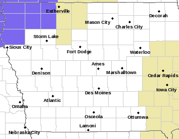
(Radio Iowa) – Forecasters say wintry weather will return to Iowa’s northwestern half on Tuesday and it’ll mean slow-going for traffic with two-to-four inches of snow possible along with a light glazing of ice. Meteorologist Brad Small, at the National Weather Service, says a Winter Weather Advisory is posted from 6 A-M to 6 P-M Tuesday for seven counties in the far northwest corner of the state. “The snow will begin during the overnight hours early Tuesday morning and then continue for much of the day and mainly affect northwest and north-central Iowa, with even higher amounts farther north into Minnesota,” Small says. “Central Iowa will only see light snow amounts and southeast Iowa will see little or nothing.”
The pre-winter storm could have a significant impact on the roads and travel, Small says, especially for areas like Estherville and Algona, where snowfall may be the heaviest. “We’ll see brisk northwest winds, gusting 20 to 30 miles per hour, so the flow won’t be too dry and fluffy but when you get those winds coupled with existing snowfall there, there could be some low visibilities and blowing snow,” Small says. “There could also be a period of freezing drizzle with the snow, too, as it goes in and out, so we can see a light glazing potential but the main threat is going to be the snow.”
Winter Weather Advisory on Tuesday for parts of NW Iowa.
The snowfall is expected to taper off along a line of cities that includes Council Bluffs, Atlantic, Ames and Waterloo. The snow that falls will likely be sticking around for a while, as bitter cold weather will come behind the storm front. “After the snow diminishes and ends Tuesday night, we will be dry Wednesday and Thursday but that will also be accompanied with much colder temperatures,” Small says. “Lows Wednesday night will be in the single digits and teens across the state, and with those brisk northwest winds, we’ll see wind chills below zero for periods from Wednesday into Thursday across northern Iowa.”
Find out about the latest road conditions by calling 5-1-1 or log on to the Iowa D-O-T’s travel information website 5-1-1-i-a-dot-org.
(Updated 4:45-a.m.)
Today: Partly cloudy. High 52. S @ 10-20 mph.
Tonight: Mostly cloudy. Low 35. SE @ 10-15.
Tomorrow: Cloudy w/light rain mixed at times w/snow, becoming all snow (Less than 1″ expected). High early around 37 w/temps falling into the 20’s. SE-N @ 15
Wednesday: P/Cldy & blustery. High 25.
Thursday: P/Cldy & breezy. High near 40.
Sunday’s high was 48 and our low this morning was 13. This day last year the high was 46 and the low was 18. The all-time record high was 63 set in 1941 and the record low was -16 set in 1952. Sunrise today is 7:23 a.m. and sunset is set for 4:52 p.m.
Today: Cloudy, then gradually becoming mostly sunny, with a high near 43. Breezy, with a north northwest wind 6 to 16 mph, with gusts as high as 24 mph.
Tonight: Mostly clear, with a low around 21. Calm wind becoming south around 6 mph after midnight.
Monday: Sunny, with a high near 51. Breezy, with a south wind 8 to 17 mph, with gusts as high as 26 mph.
Monday Night: Mostly cloudy, with a low around 33. South wind 6 to 8 mph, with gusts as high as 20 mph.
Tuesday: A chance of rain before 3pm, then a chance of rain and snow. Cloudy, with a high near 46. Breezy, with an east southeast wind 7 to 12 mph becoming north northwest 13 to 18 mph in the afternoon. Winds could gust as high as 28 mph. Chance of precipitation is 40%. Little or no snow accumulation expected.
Tuesday Night: A 30 percent chance of snow before midnight. Mostly cloudy, with a low around 14. Blustery.
Wednesday: Mostly sunny, with a high near 25. Blustery.
Yesterday’s high was 57 and the low was 33. This day last year the high was 61 and the low was 18. The all-time record high was 61 set in 1998 and the record low was 1 set in 1998. Sunrise today is 7:22 a.m. and sunset is set for 4:52 p.m.
Skyscan Forecast Saturday, November 26, 2022 Austin Romer
Today: Sunny with clouds increasing through the day. SW @ 15. High 55.
Tonight: Cloudy. Slight chance of rain. N @ 15. Low 36.
Sunday: Mostly cloudy. N @ 15. High 44,
Sunday Night: Clear. S @ 5-10. Low 21.
Monday: Partly cloudy. S @ 15. High 51.
Tuesday: Cloudy and cooling. Moderate chance of rain and snow. NW @ 15. High 41.
Yesterday’s high was 53 and the low was 18. This day last year the high was 49 and the low was 25. The all-time record high was 69 set in 1996 and the record low was -9 set in 1898. Sunrise today is 7:21 a.m. and sunset is set for 4:53 p.m.
Today: Areas of morning fog; Mostly sunny. High 52. NW-SW @ 10.
Tonight: Fair to partly cloudy. Low 27. SW @ 5-10.
Tomorrow: Partly cloudy to cloudy. High 54. SW @ 10-20.
Sunday: Cldy w/a chance of mixed rain/snow in the morning; Becoming p/cldy. High 45.
Monday: P/Cldy. High near 50.
Thursday’s High in Atlantic was 49. Our Low this morning, 20. Last year on this date the High in Atlantic was 32 and the Low was 12. The Record High on this date was 71 in 1960. The Record Low was -6 in 1991.
(Today) Thanksgiving Day: Patchy fog before 9am. Otherwise, cloudy through mid morning, then gradual clearing, with a high near 46. Southwest wind 5 to 14 mph becoming north northwest in the afternoon. Winds could gust as high as 22 mph.
Tonight: Mostly clear, with a low around 25. North northwest wind 5 to 9 mph becoming light northwest after midnight.
Friday: Sunny, with a high near 50. Calm wind becoming west southwest 5 to 8 mph in the morning.
Saturday: Mostly sunny, with a high near 53.
Saturday Night: A chance of rain before 3am, then a chance of rain and snow. Cloudy, with a low around 29. Chance of precipitation is 40%.
Sunday: Mostly sunny, with a high near 44.
Wednesday’s High in Atlantic was 60. Our Low was 20. Last year on this date the High in Atlantic was 54 and the Low was 18. The Record High on this date was 68 in 2011. The Record Low was -2 in 1898.


