
(Radio Iowa) – Iowans will hear some new terminology when the winds of winter start to blow. National Weather Service meteorologist Chad Hahn says the agency is abandoning a few familiar terms in favor of language that’s a little more direct.
If the air temperature is ten-below-zero, that’s quite frigid whether there’s a breeze or not, so Hahn says it makes sense to have an alternative to wind chill advisories when it’s not windy.
The term “wind chill” isn’t going away, as Hahn says it remains very useful during the winter months to describe what the air temperature feels like with a combination of cold temperatures and sustained winds.
 It’s possible we’ll hear about the heat index again in a few days, as the forecast calls for parts of Iowa to see unseasonably warm high temperatures in the low 90s by the weekend.
(Radio Iowa) – State climatologist Justin Glisan confirms September is at the top of the record list after recording just seven-tenths of an inch of precipitation.
He says it was a warm one as well.
Glisan says the early outlook for October doesn’t show much change from September.
He says it doesn’t look like we will make up the lost precipitation from September anytime soon.
The State Fire Marshal’s website shows burn bans in 16 counties due to the dry conditions.
Today: Sunny with a high near 81. Breezy with a south southwest wind 5 to 10 mph increasing to 15 to 20 mph in the morning. Winds could gust as high as 30 mph.
Tonight: Mostly clear with a low around 44.
Thursday: Sunny with a high near 80.
Friday: Sunny with a high near 75. East wind around 10 mph, with gusts as high as 20 mph.
Saturday: Sunny with a high near 92. Windy.
Sunday: Sunny with a high near 73. Breezy.
Today: Sunny with a high near 70. North wind 5 to 10 mph.
Tonight: Mostly clear with a low around 42.
Wednesday: Sunny with a high near 80. Breezy, with a south southwest wind 10 to 20 mph, with gusts as high as 25 mph.
Thursday: Sunny with a high near 81
Friday: Sunny with a high near 76.
Saturday: Sunny with a high near 85. Breezy.
Today: Sunny with a high near 85. Light and variable wind becoming south southwest 5 to 10 mph in the morning.
Tonight: Mostly clear with a low around 48. Breezy, with a north wind 15 to 20 mph, with gusts as high as 25 mph.
Tuesday: Sunny with a high near 68. North wind at 10 mph, with gusts as high as 20 mph.
Wednesday: Sunny with a high near 78. Breezy, with a south southwest wind 10 to 20 mph, with gusts as high as 25 mph.
Thursday: Sunny with a high near 79.
Friday: Sunny with a high near 74.
Today: Sunny, with a high near 86. Winds E/NE at 5-10 mph this morning.
Tonight: Clear, with a low around 53.
Tomorrow: Sunny, with a high near 85. S/SE winds 5-10 mph in the morning.
Tom. Night: Mostly clear & breezy. Low 49. W/NW winds @ 10-15 mph becoming northerly & gusting to near 25 mph.
Tuesday: Sunny, with a high near 68. North wind 5 to 10 mph.
Tuesday Night: Partly cloudy, with a low around 43.
Wednesday: Sunny, with a high near 78. Breezy.
Saturday’s High in Atlantic was 88. The Low was 44. Last year on this date, the High in Atlantic was 92 and the Low was 65. The Record High in Atlantic on Sept. 29th was 96 degrees in 1953. The Record Low was 17 in 1899. Sunrise: 7:14. Sunset: 7:06
Friday’s High in Atlantic was 83. The Low was 43. Last year on this date, the High in Atlantic was 82 and the Low was 47. The Record High in Atlantic on Sept. 28th was 100 in 1953. The Record Low was 22 in 1908. Sunrise: 7:14. Sunset: 7:07
(Radio Iowa) – The latest report from the U-S Drought Monitor showed a slight improvement with six percent of the state showing no dry conditions. D-N-R hydrologist Tim Hall says the majority of the state is listed as “abnormally dry,” or just before the drought level. “That’s either a precursor to or remnants of coming out of drought. So in the conditions we’re in where we’re kind of on the edge of being in drought and not being in drought,” Hall says. There are some areas in western Iowa and far northeast that have moderate drought. Hall says the dry weather can be an asset to farmers right now.
“From an ag producer perspective, being dry is great because it doesn’t cause any problems with getting into the field. You get really good grain dry down. Those are all good,” he says. Hall says it would not be good to go much longer without some rainfall. “Thinking forward to the next crop year, we need to be adding some moisture into the soil profile,” Hall says. “So it’s not good when we have a September like we’re in. This is likely to end up being the driest September ever on record for the state of Iowa.” Hall says when you look outside of agriculture needs, the state’s water systems are okay. 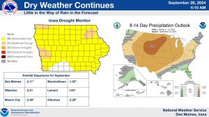
“Fortunately for the state of Iowa, we had some wetter than normal months for most of the last 12 months, going back to October of last year. So coming out of some pretty decent wet months this spring and early this summer, we’re in much better shape than we would be had we not had that rain,” he says. Hall says rain naturally drops off as we head through fall and into winter, so making up the gap from the dry September may not be easy.
Today: Sunny, with a high near 82. N/NE winds 5-10 mph.
Tonight: Mostly clear, with a low around 53. N/NE wind around 5 mph.
Tomorrow: Sunny, with a high near 84. N/NE winds 10-20 mph.
Sunday: Sunny, with a high near 83.
Monday: Sunny, with a high near 84.
Tuesday: Sunny, with a high near 67.
Thursday’s High in Atlantic was 83. The Low was 44. Last year on this date, the High in Atlantic was 77 and the Low was 46. The Record High in Atlantic on Sept. 27th was 94 in 2021. The Record Low was 28 in 1893. Sunrise: 7:12. Sunset: 7:09
Today: Patchy fog before 9am. Otherwise, sunny, with a high near 80. S/SE winds 5-10 this afternoon.
Tonight: Mostly clear, with a low around 51.
Tomorrow: Sunny, with a high near 80. N/NW winds 5-10 in the afternoon.
Tom. Night: Partly cloudy, with a low around 53. North northeast wind around 5 mph.
Saturday: Sunny, with a high near 83.
Sunday: Sunny, with a high near 81.
Monday: Sunny, with a high near 82.
Wednesday’s High in Atlantic was 81. The Low was 44. Last year on this date, the High in Atlantic was 76 and the Low was 48. The Record High in Atlantic on Sept. 26th was 91 in 1897 & 1998. The Record Low was 24 in 1984. Sunrise: 7:11. Sunset: 7:11


