
(Radio Iowa) – Forecasters say more wintery weather is likely in the week ahead, after a weekend punctuated by an ice storm that coated many areas of the state in ice a quarter-inch thick, which brought travel to a standstill in many communities. National Weather Service meteorologist Mike Fowle says the next storm system will move in tomorrow (Tuesday). “We do have a chance of a little bit of light snow or rain or snow on Tuesday,” Fowle says. “We have a weak weather system that’s going to move across on Tuesday, and then a little bit colder on Wednesday, behind that first system, and then it bears watching, we have another system on Thursday. That one could be a little bit stronger.”
Fowle says forecasters are still trying to gauge the severity of that approaching Thursday storm. “There’s some uncertainty exactly where the heaviest precipitation may fall,” Fowle says. “Right now, it appears it may clip portions of far northern and northeastern Iowa, but we’re going to have to keep a close eye on that one. That one could bring some wintry precipitation as well as some strong and gusty winds.”

National Weather Service graphic
The first day of winter is this coming Saturday. The Climate Prediction Center says Iowa could be in for a warm Christmas holiday in nine days, with no mention of snowfall.
DES MOINES, Iowa [KCCI] — Sunday (Dec. 15th) marked three years since the December derecho hit the Hawkeye state. The intense weather system created 63 tornadoes. That broke the record for most tornadoes in a single day here in Iowa. Five people across the Midwest were killed.
The storm caused more than $1 billion in damage. It was the first December derecho ever recorded in U.S. history.
Today: Mostly sunny & windy. High near 47. West winds 10-20 this morning, gusting to near 30 this afternoon.
Tonight: Mostly clear, with a low around 23. West wind 5 to 10 mph.
Tuesday: Mostly cloudy, with a high near 43. Winds becoming SE at 10-20 mph.
Tue. Night: Mostly cloudy, with a low around 20.
Wednesday: Sunny, with a high near 32. NW winds 5-10 mph.
Thursday: Mostly sunny & breezy, with a high near 47.
Sunday’s High in Atlantic was 40. Our Low was 27. Last year on this day (12/16), the High in Atlantic was 40 & the Low was 30. The Record High on this date was 59 in 1962, & the Record Low was -22, in 1951. Sunrise: 7:39; Sunset: 4:51.
Today: **Winter Weather Advisory from 4-p.m. today until NOON Saturday for mixed precipitation (snow/sleet/ice)** Mostly cloudy w/a 20% chance of freezing rain after 4pm. High near 27. E winds 15-30 mph. Wind chill values as low as -5.
Tonight: Freezing rain likely through midnight, then rain is likely. Temperature rising to around 34 overnight. E/SE winds @ 15-30 mph. New ice accumulation of less than a 0.1 of an inch possible.
Tomorrow: Rain likely, mainly before noon. Cloudy, with a high near 38. E/SE winds @ 10-5 mph becoming NE in the afternoon.
Tom. Night: Cloudy, with a low around 28.
Sunday: Mostly cloudy, with a high near 44.
Monday: Mostly sunny & breezy, with a high near 44.
Tuesday: Mostly sunny, with a high near 41.
Thursday’s High in Atlantic was 22. The Low was 8. Last year on this date, the High in Atlantic was 49 & the Low was 17. The Record High here on Dec. 13th, was 65 in 1921, and the Record Low was -20 in 1961. Sunrise: 7:37. Sunset: 4:50.
A WINTER WEATHER ADVISORY IS IN EFFECT FROM THIS AFTERNOON THROUGH SATURDAY MORNING
The Advisory begins at 2-p.m. today for far west/southwest Iowa, and at 4-p.m for Cass and other Counties in the listening area, as well as most of the State.
* WHAT…Mixed precipitation expected. Total snow and sleet accumulations under one inch and ice accumulations around one to two tenths of an inch.
* IMPACTS…Roads, and especially bridges and overpasses, will likely become slick and hazardous. Plan on slick, and even
treacherous at times, road conditions Friday night into Saturday morning. The hazardous conditions could impact the Friday evening commute in southwest Iowa.
* ADDITIONAL DETAILS…Branches and power lines may become ice coated. East-Southeast winds 10-20 mph could cause tree limbs to break or power outages to occur.

Last Map Update: Fri, Dec 13, 2024 at 6:56:26 am CST; Winter Weather Advisory (Counties in lavender); Ice Storm Warning (Counties in purple)
PRECAUTIONARY/PREPAREDNESS ACTIONS…
Be prepared for slippery roads. Slow down and use caution while driving. If you are going outside, watch your first few steps taken on stairs, sidewalks, and driveways. These surfaces could be icy and slippery, increasing your risk of a fall and injury.
For the latest travel conditions, check the Iowa 511 app, www.511ia.org, or dial 511.
(Radio Iowa) – Wind chill indices dipped as low as 20 below zero in parts of northern Iowa this (Thursday) morning, with air temperatures in many cities in the negative teens. National Weather Service meteorologist Cory Martin says this is likely the coldest air Iowans have endured since last January, and more scattered snow is on the way. “We’re expecting precipitation to spread over much of the state by late in the day tomorrow,” Martin says, “and temperatures will likely be cold enough to support freezing rain.” That freezing rain translates to black ice on roads and Martin says driving may quickly become hazardous.
“We’re looking at an icing of up to a 10th of an inch, maybe a few spots up to as much as two-tenths of an inch, which may cause some travel concerns,” Martin says. “As we go through Friday night into Saturday morning, we’re going to see temperatures continue to warm and actually go above freezing, which should eventually put an end to the icing concerns as we move over to just a straight liquid rain.”
The forecast calls for the precipitation to end later Saturday while Sunday should be dry with highs that are decent for December in Iowa in the 30s and 40s.
Today: Cloudy w/a 30% chance of snow or flurries this morning. Gradually becoming mostly sunny, with a high near 20. E/NE winds 5-10 mph. Wind chill values as low as 5. New snow accumulation of less than a half inch possible.
Tonight: Partly cloudy, with a low around 9. E winds 10-20. Wind chill values as low as -5.
Tomorrow: A chance of freezing rain after noon, mixing with rain after 3pm. Mostly cloudy, with a high near 34. E/SE winds 1-25 mph. Wind chill values as low as -5. New precipitation amounts of less than a tenth of an inch possible.
Tom. Night: Freezing rain before midnight, then rain. Low around 25. New ice accumulation of less than a 0.1 of an inch possible.
Saturday: A 40% chance of rain, mainly before noon. Mostly cloudy, with a high near 40.
Saturday Night: Mostly cloudy, with a low around 24.
Sunday: Partly sunny, with a high near 44.
Sunday Night: Mostly cloudy, with a low around 31.
Monday: Partly sunny, with a high near 43. Breezy.
Wednesday’s High in Atlantic was 19. Our Low this morning, 11. Last year on this date, the High in Atlantic was 39 & the Low was 16. The Record High here on Dec. 12th, was 62 in 1921 & 1968, and the Record Low was -20 in 1932. Sunrise: 7:36. Sunset: 4:50.
(Radio Iowa) – Parts of Iowa saw periods of moderate to heavy snowfall last (Tuesday) night and this morning, but National Weather Service meteorologist Cory Martin says there wasn’t much in the way of accumulation and most of the snow melted on the roads and sidewalks. “Accumulations look like an inch or less,” Martin says, “and we see some collection on roadways, but it looks like the DOT is out after it already this morning.” The bigger story from the arrival of this weather front may be the cold, as Martin says temperatures will fall throughout the day, turning bitter cold by tonight. “We’ve got northwest winds picking up this morning, and that’s going to continue to push cold air into the state here that’s going to hang around here for about the next 48 to 60 hours,” Martin says. “We’re looking at a stretch of wind chills hovering anywhere from the single digits above or below zero, but up there in northern Iowa, we could be looking at wind chills in the teens below zero at times.” 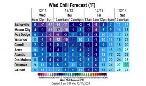
Another storm front is expected late in the week which could bring us more snow to many areas of Iowa. “Ironically, we’re looking at temperatures warming up as the system comes through, but probably still cool enough, at least for a little bit, to give us a shot at some more wintry precip,” Martin says. “Right now, it’s looking like freezing rain would probably be favored, but it doesn’t take much of that start causing some travel impact on the areas.”
Keep up with changing road conditions at the Iowa D-O-T’s interactive travel map at 511ia.org.
Today: A chance of flurries this morning, otherwise partly sunny-to-sunny & windy w/temperatures falling into the into the upper teens. NW winds 15-30 mph. Wind chill values as low as 5.
Tonight: Increasing clouds, with a low around 10.
Tomorrow: Cloudy w/a slight chance of snow before noon, then a chance of flurries. Gradually becoming mostly sunny. A high near 20. E winds 5-10 mph. Wind chill values as low as zero.
Tom. Night: Partly cloudy, with a low around 9.
Friday: Mostly cloudy w/a 40% chance of freezing rain after noon. High near 33.
Friday Night: Freezing rain. Low around 25.
Saturday: Mostly cloudy w/a slight chance of rain before noon. High near 37.
Sunday: Partly sunny, with a high near 44.
Tuesday’s High in Atlantic was 37. Our Low this morning, 18. Snowfall Tuesday into early today amounted to .2″ (Two-tenths of an inch) at KJAN (equal to a Trace of liquid precipitation). Last year on this date, the High in Atlantic was 50 & the Low was 17. The Record High here on Dec. 11th, was 64 in 1965, and the Record Low was -14 in 1917. Sunrise: 7:36. Sunset: 4:50.


