
Today: Patchy fog before 8am. Otherwise, mostly sunny, with a high near 94. Heat index values as high as 106. South wind 5 to 10 mph. HEAT ADVISORY in effect from 1-until 8-p.m. today.
Tonight: Partly cloudy w/a 30% chance of showers and thunderstorms this evening. Low around 65.
Tomorrow: Mostly sunny, with a high near 84. North northeast wind around 5-10 mph.
Wednesday: Mostly sunny, with a high near 79.
Thursday: Sunny, with a high near 77.
Sunday’s High in Atlantic was 91. Our Low was 67. Last year on this date, the High in Atlantic was 84 and the Low was 60. The All-Time Record High in Atlantic on July 15th, was 110 in 1936. The Record Low was 42 in 1930. Sunrise: 5:58; Sunset: 8:52.
Pottawattamie-Mills-Montgomery-Fremont-Page Counties: EXCESSIVE HEAT WARNING REMAINS IN EFFECT UNTIL 8 PM TODAY (7/15)
* WHAT…Dangerously hot conditions with heat index values up to 108.
* IMPACTS…Heat related illnesses increase significantly during extreme heat and high humidity events.
PRECAUTIONARY/PREPAREDNESS ACTIONS…
Drink plenty of fluids, stay in an air-conditioned room, stay out of the sun, and check up on relatives and neighbors. Do not leave young children and pets in unattended vehicles. Car interiors will reach lethal temperatures in a matter of minutes.
Take extra precautions when outside. Wear lightweight and loose fitting clothing. Try to limit strenuous activities to early morning or evening. Take action when you see symptoms of heat exhaustion and heat stroke.
To reduce risk during outdoor work, the Occupational Safety and Health Administration recommends scheduling frequent rest breaks in shaded or air conditioned environments. Anyone overcome by heat should be moved to a cool and shaded location. Heat stroke is an emergency! Call 9 1 1.
Audubon-Guthrie-Dallas-Cass-Adair-Madison-Adams-Union-Taylor-Ringgold Counties: A HEAT ADVISORY REMAINS IN EFFECT FROM 1 PM TO 8 PM TODAY.
* WHAT…Heat index values of 100 to 110 expected.
* WHERE…Along and south of I-80..
* IMPACTS…Hot temperatures and high humidity may cause heat illnesses.
PRECAUTIONARY/PREPAREDNESS ACTIONS…
Drink plenty of fluids, stay in an air-conditioned room, stay out of the sun, and check up on relatives and neighbors.
HEAT ADVISORY IN EFFECT FROM 1 PM TO 8 PM TODAY for Sac-Crawford-Carroll-Audubon-Guthrie-Dallas-Polk-Cass-Adair-Madison-Adams-Union-Taylor-Ringgold Counties. EXCESSIVE HEAT WARNING REMAINS IN EFFECT FROM NOON TO 8 PM TODAY for Pottawattamie-Mills-Montgomery-Fremont-Page Counties.
Today: Sunny, with a high near 93. Heat index values as high as 105. South wind 10 to 20 mph.
Tonight: Increasing clouds, with a low around 72. Southeast wind 5 to 10 mph.
Monday: Mostly sunny, with a high near 94. Heat index values as high as 106. South winds 5 to 10 mph becoming NW & gusting to around 20 mph.
Monday Night: A 30% chance of showers and thunderstorms. Low around 67.
Tuesday: Mostly sunny, with a high near 84. North northeast wind around 10 mph.
Tuesday Night: Partly cloudy, with a low around 62.
Wednesday: Mostly sunny, with a high near 79.
Saturday’s High in Atlantic was 89. The Low was 72. Last year on this date, the High in Atlantic was 83 and the Low was 61. The All-Time Record High in Atlantic on July 14th, was 112 in 1936. The Record Low was 41 in 1967. Sunrise: 5:58; Sunset: 8:53.
Today: Sunny, with a high near 93. Heat index values as high as 103. South wind 10-20 mph.
Tonight: Partly cloudy, with a low around 71. South wind 5 to 10 mph. HEAT ADVISORY in effect from 1-until 8-p.m.
Sunday: Sunny, with a high near 94. Heat index values as high as 103. Southwest wind 10-20 mph.
Sunday Night: Mostly clear, with a low around 73.
Monday: Mostly sunny, with a high near 95. South wind 10-20 mph.
Monday Night: A 30 percent chance of showers and thunderstorms. Mostly cloudy, with a low around 67.
Tuesday: A 20 percent chance of showers and thunderstorms before 1pm. Partly sunny, with a high near 82.
Friday’s High in Atlantic was 86. Our Low this morning was 64. Last year on this date, the High in Atlantic was 84 and the Low was 62. The All-Time Record High in Atlantic on July 13th, was 108 in 1936. The Record Low was 44 in 1897. Sunrise: 5:58; Sunset: 8:53.
(Radio Iowa) – Forecasters say an exceptionally hot and humid weekend is ahead and Iowans are warned not to overdo it if they’re working or playing outdoors. Carla Johnson, an infection prevention specialist with Van Diest Medical Center in Webster City, says falling victim to heat stroke can be very risky, so know the symptoms.
A person with heat stroke might also seem confused, and they may even pass out.
Another risk is heat exhaustion, which she says has a varied set of warning signs.
Seven southwest Iowa counties are under an excessive heat watch from Sunday afternoon through Monday night, as forecasters say heat indices may reach 112 degrees.
Today: Sunny, with a high near 86. South southeast wind 5 to 10 mph, with gusts to near 20 mph.
Tonight: Mostly clear, with a low around 68. Southeast wind 5 to 10 mph.
Saturday: Sunny, with a high near 92. Heat index values as high as 101. South wind 5 to 10 mph.
Saturday Night: Mostly clear, with a low around 72.
Sunday: Sunny, with a high near 95.
Monday: Mostly sunny, with a high near 93.
Monday Night: A 30% chance of showers & thunderstorms after midnight. Low around 68.
Tuesday: Partly sunny, with a high near 83.
Thursday’s High in Atlantic was 85. Our Low this morning was 59. Last year on this date, the High in Atlantic was 84 and the Low was 60. The All-Time Record High in Atlantic on July 12th, was 106 in 1939. The Record Low was 47 in 1895 & 1975. Sunrise: 5:56; Sunset: 8:54.
(Radio Iowa) – The latest Drought Monitor report for Iowa is dramatically different than it was one year ago. One year ago 100 percent of Iowa was either in drought or abnormally dry conditions. The latest Drought Monitor map shows just Scott County and a small part of Clinton County now show abnormally dry conditions. That amounts to less than one percent of the state. 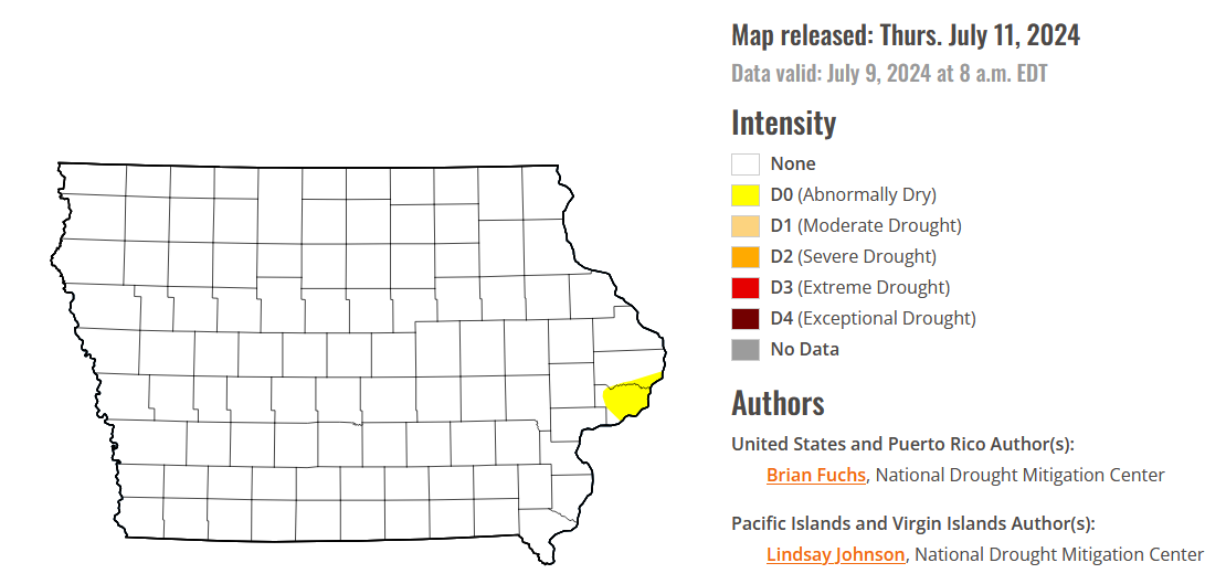
State Climatologist Justin Glisan says the last time Iowa had no abnormally dry areas was in early May of 2020. The state has been free of actual drought conditions since late May of this year – which stopped four-years of drought conditions.
Today: Sunny, with a high near 83. E/NE winds around 5 mph.
Tonight: Clear, with a low around 63.
Tomorrow: Mostly sunny, with a high near 86. South southeast wind 5 to 10 mph.
Saturday: Mostly sunny, with a high near 92.
Sunday: Sunny, with a high near 95.
Monday: Mostly sunny, with a high near 94.
Wednesday’s High in Atlantic was 84. We received .02″ rain yesterday afternoon. Our Low this morning was 58. Last year on this date, the High in Atlantic was 90 and the Low was 67. The All-Time Record High in Atlantic on July 11th, was 104 in 1936. The Record Low was 43 in 1895. Sunrise: 5:55; Sunset: 8:54.
(Iowa News Service) – Health care experts are reminding Iowans to be careful in the summertime sun. From sunburns and bike safety to water accidents and sports injuries, they remind people sometimes virtual care is available and reduces the time to see a provider.
Dr. Donna O’Shea, chief medical Officer of population health for UnitedHealthcare, said the company provides various tips to staying safe in the sun but reminds Iowans it is important to pay close attention to danger signs when outside for an extended period of time in Iowa’s sometimes sweltering summertime heat and high humidity.
“There is such a condition as overheating and heatstroke,” O’Shea pointed out. “It’s important to recognize those signs early. The signs of overheating do include headaches, nausea or dizziness. And it can be especially important to watch children because their internal cooling systems aren’t fully developed yet.”

Iowa has escaped the deadly heat which had more than 36 million Americans under a warning in recent days, but temperatures are expected to reach into the mid-90s next week with higher humidity. O’Shea reminded people medical assessment for a variety of injuries is also available virtually, 24/7.
She noted virtual care can be crucial in the state’s rural areas where people often can’t make it quickly to an urgent care facility or for helping decide if they need care for less serious conditions. And it’s available 24/7. “If it’s related to hydration or heat stroke, if you’re able to keep fluids down, virtual care can help you determine how much, how long to wait before you go to the emergency room,” O’Shea explained. “Same thing even for sunburns or bike safety. Do I need to go in? Do you think I need stitches? We don’t think about that.”
O’Shea also reminded people to watch kids around water since drowning is the number one cause of death for children between the ages of one and four. The state health department said it is the leading cause of death by unintentional injury of young children in Iowa.
Today: Mostly sunny w/a 40% chance of afternoon showers and thunderstorms. High near 83. NW winds at around 5-10 mph.
Tonight: Partly cloudy w/a 20% chance of showers and thunderstorms. Low around 61.
Tomorrow: Mostly sunny, with a high near 83. E/SE winds 5-10.
Friday: Sunny, with a high near 86.
Saturday: Sunny, with a high near 91.
Sunday: Sunny, with a high near 94.
Tuesday’s High in Atlantic was 86. Our Low was 60. We received .05″ rain Tuesday afternoon, in Atlantic (at KJAN). Last year on this date, the High in Atlantic was 85 and the Low was 65. The All-Time Record High in Atlantic on July 10th, was 104 in 1930 & 1936. The Record Low was 46 in 1895 & 1996. Sunrise: 5:55; Sunset: 8:55.


