712 Digital Group - top

Two Arrested for Theft in Red Oak

News

June 14th, 2014 by admin

The Red Oak Police Department reports the arrest of two individuals on theft charges Saturday (6/14).  At 1:06pm Officers arrested 48-year-old Bradley Dean Gary of Red Oak and 47-year-0ld Barbara Darlene Wilson of Red Oak at a residence in the 600 block of East Sunset Avenue in Red Oak.  Gary was charged with 4 counts of Theft in the 5th Degree and Wilson was charged with one count of Theft in the 5th Degree.  Both individuals were taken to the Montgomery County Law Enforcement Center and held on $300 bond each.

Shooting in Council Bluffs Saturday

News

June 14th, 2014 by admin

The Council Bluffs Police Department report a shooting took place on Saturday, June 14th in the parking lot of 37 Bluff Street in Council Bluffs.  At 3:11pm a vehicle driven by 16-year-old Justice Alstadt of Council Bluffs with two passengers aboard were leaving the parking lot when an unidentified male fired four shots with a hand gun at the vehicle.  One of the bullets struck Alstadt in the right abdomen and she was taken to Mercy Hospital for treatment of non-life threatening injuries and is in stable condition.

The investigation into the attempted murder is ongoing.

Hazardous Weather Outlook for Cass & area Counties: 6/14/14 5-p.m.

Weather

June 14th, 2014 by Ric Hanson

SAC-CALHOUN-WEBSTER-CRAWFORD-CARROLL-GREENE-BOONE-AUDUBON-GUTHRIE-

DALLAS-CASS-ADAIR-MADISON-ADAMS-UNION-TAYLOR-RINGGOLD-

SAT JUN 14 2014

TONIGHT: THERE IS A MODERATE RISK FOR SEVERE WEATHER THROUGH TONIGHT. THE GREATEST POTENTIAL WILL BE FROM 9 PM TO 4 AM. DAMAGING WIND GUSTS IN EXCESS OF 70 MPH IS THE PRIMARY THREAT HOWEVER GOLF BALL SIZED HAIL AND ISOLATED TORNADOES MAY OCCUR. AN AREA OF HEAVY RAINFALL IS POSSIBLE TONIGHT. RAINFALL AMOUNTS EXCEEDING 3 INCHES MAY OCCUR.

(updated) Zone forecast for Cass & area Counties in IA

Weather

June 14th, 2014 by Ric Hanson

232 PM CDT SAT JUN 14 2014

LATE THIS AFTERNOON…MOSTLY CLOUDY. WINDY. SOUTH WIND 25 TO 30 MPH WITH GUSTS TO AROUND 45 MPH.

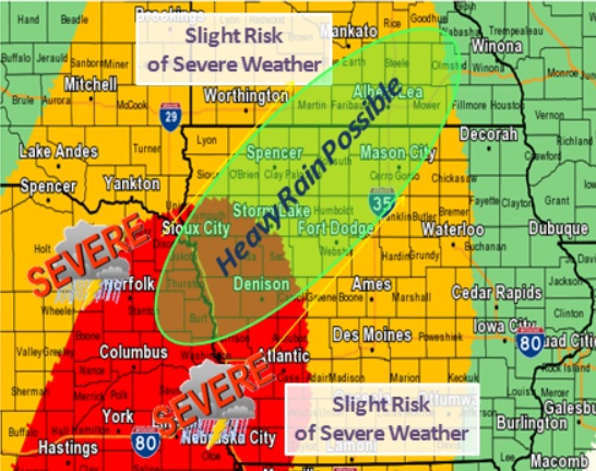
TONIGHT…MOSTLY CLOUDY. BREEZY. ISOLATED THUNDERSTORMS IN THE EVENING…THEN SCATTERED THUNDERSTORMS BEFORE MIDNIGHT AND EARLY MORNING. NUMEROUS THUNDERSTORMS EARLY IN THE MORNING. SOME THUNDERSTORMS MAY BE SEVERE WITH DAMAGING WIND OVERNIGHT. LOW IN THE MID 60S. SOUTH WIND 20 TO 25 MPH. GUSTS UP TO 40 MPH DECREASING TO 30 MPH AFTER MIDNIGHT. CHANCE OF THUNDERSTORMS 70 PERCENT.

SUNDAY…MOSTLY CLOUDY WITH A CHANCE OF THUNDERSTORMS THROUGH MID MORNING…THEN PARTLY SUNNY WITH A SLIGHT CHANCE OF THUNDERSTORMS BEFORE NOON. SUNNY IN THE AFTERNOON. SOME THUNDERSTORMS MAY PRODUCE HEAVY RAINFALL THROUGH MID MORNING. HIGH IN THE LOWER 80S. WEST WIND 10 TO 15 MPH. GUSTS UP TO 25 MPH IN THE MORNING. CHANCE OF THUNDERSTORMS 40 PERCENT.

SUNDAY NIGHT…MOSTLY CLEAR. LOW IN THE LOWER 60S. SOUTH WIND 5 TO 10 MPH.

MONDAY…MOSTLY SUNNY. A 40 PERCENT CHANCE OF THUNDERSTORMS IN THE AFTERNOON. BREEZY. HIGH IN THE MID 80S. SOUTH WIND 5 TO 15 MPH INCREASING TO 15 TO 20 MPH WITH GUSTS TO AROUND 30 MPH IN THE AFTERNOON.

MONDAY NIGHT…MOSTLY CLOUDY WITH A 50 PERCENT CHANCE OF THUNDERSTORMS. BREEZY. LOW AROUND 70. SOUTH WIND 10 TO 20 MPH WITH GUSTS TO AROUND 30 MPH.

Severe weather is still in the forecast for parts of Iowa overnight tonight

News, Weather

June 14th, 2014 by Ric Hanson

The National Weather Service in its mid-morning weather briefing, Saturday, said severe weather is still in the forecast for tonight across portions of Iowa. The primary threat in western Iowa appears to be from damaging winds in excess of 58-miles per hour. However, large hail and isolated tornadoes are also possible.The area is under a “Moderate risk” for severe weather.

Areas in red are under a "Moderate" risk of severe weather tonight, areas in yellow will experience a "Slight" risk for severe weather. (NWS graphic)

Areas in red are under a “Moderate” risk of severe weather tonight, areas in yellow will experience a “Slight” risk for severe weather. (NWS graphic)

Keep in mind, that winds of 60-to 80-miles per hour can have the same effect as an EF-1 tornado, and tree debris may be difficult to see on the road at night.

If you are camping or have plans to do so, make sure you have a way to receive weather information and a safe place for emergency shelter, and if at home, keep your weather radio ready to go with fresh batteries.

Wind Advisory for Far Southwest Iowa Today

Weather

June 14th, 2014 by admin

POTTAWATTAMIE-MILLS-MONTGOMERY-FREMONT-PAGE

...WIND ADVISORY IN EFFECT FROM 11 AM THIS MORNING TO 5 PM CDT
THIS AFTERNOON...

THE NATIONAL WEATHER SERVICE IN OMAHA/VALLEY HAS ISSUED A WIND
ADVISORY...WHICH IS IN EFFECT FROM 11 AM THIS MORNING TO 5 PM CDT
THIS AFTERNOON.

* WINDS...SOUTHERLY WINDS WILL INCREASE TO AROUND 25 TO 30 MPH
  TODAY WITH GUSTS UP TO 40 TO 45 MPH AT TIMES.

* IMPACTS...BE SURE TO SECURE LOOSE ITEMS AROUND YOUR HOME OR
  BUSINESS. HIGH PROFILE VEHICLES MAY HAVE A DIFFICULT TIME
  DRIVING IN THE HIGH WIND.

PRECAUTIONARY/PREPAREDNESS ACTIONS...

A WIND ADVISORY MEANS THAT WINDS OF 30 MPH OR GREATER ARE EXPECTED.
WINDS THIS STRONG CAN MAKE DRIVING DIFFICULT...ESPECIALLY FOR HIGH
PROFILE VEHICLES. USE EXTRA CAUTION.

7AM Sportscast 06-14-2014

Podcasts, Sports

June 14th, 2014 by admin

w/ Chris Parks

Play

7AM Newscast 06-14-2014

News, Podcasts

June 14th, 2014 by admin

w/ Chris Parks

Play

Friday High School Baseball and Softball Scores (6-13-2014)

Sports

June 14th, 2014 by admin

BASEBALL

  • Creston 6, Atlantic 1
  • Coon Rapids-Bayard 12, Boyer Valley, Dunlap 2
  • East Mills 16, Clarinada Academy 1 (3 innings)
  • Exira-EHK 15, Woodbine 0 (4 innings)
  • Fremont-Mills 22, Essex 7 (4 innings)
  • Glidden-Ralston 8, CAM, Anita 3
  • IKM-Manning 9, Audubon 0
  • Lewis Central 8, Mason City 7
  • Martensdale-St. Marys 10, Southwest Valley 0
  • OA-BCIG 6, Maple Valley-Anthon-Oto 1
  • Pleasantville 9, Lenox 1
  • Shenandoah 5, Kuemper Catholic 3
  • Sidney 7, Stanton 3
  • St. Albert, Council Bluffs 15, Clarinda 4
  • Treynor 12, Tri-Center, Neola 2 (5 innings)
  • Underwood 8, Missouri Valley 5
  • Wayne, Corydon 12, Mt. Ayr 2 (6 innings)
  • West Harrison, Mondamin 10, Adair-Casey 9


SOFTBALL

John Stephens Classic at Creston

  • Griswold 8, Atlantic 4
  • Ankeny 12, Sioux City Heelan 2
  • Ankeny 6, Creston 2
  • Bondurant-Farrar 13, Atlantic 0
  • Bondurant-Farrar 7, Sioux City Heelan 2
  • Creston 9, Griswold 4

OA-BCIG Tournament

  • Denison-Schleswig 12, MMC-Remsen Union 0
  • Logan-Magnolia 4, Kuemper Catholic 2
  • Maple Valley-Anthon-Oto 8, Carroll 2
  • OA-BCIG 5, Newell-Fonda 4

Woodward-Granger Tournament

  • Abraham Lincoln 10, Madrid 1
  • Lewis Central 8, Woodward-Granger 7
  • Winterset 12, Abraham Lincoln 0
  • Winterset 9, Lewis Central 6
  • Woodward-Granger 12, Pleasantville 8

Other Scores

  • Boone 11, Clarke, Osceola 2
  • Council Bluffs, Abraham Lincoln 10, Madrid 1
  • Exira-EHK 12, Woodbine 0
  • Fremont-Mills 14, Essex 10
  • Martensdale-St Marys 14, Southwest Valley 4
  • Martensdale-St Marys 14, Southwest Valley 4
  • Southeast Polk 5, Clarke, Osceola 4
  • Stanton 11, Sidney 5
  • Underwood 4, Missouri Valley 3


Cardinals Edge Nationals Friday

Sports

June 14th, 2014 by admin

ST. LOUIS (AP) – Lance Lynn threw eight innings of two-hit ball and Matt Adams homered on his first swing since coming off the disabled list, leading the St. Louis Cardinals to a 1-0 victory over Jordan Zimmermann and the Washington Nationals on Friday night.

Lynn (7-4) struck out eight with no walks against the National League East leaders, who had won 10 of 13. Trevor Rosenthal added three more strikeouts in the ninth, working around rookie second baseman Kolten Wong’s two-out error on Dennard Span’s routine grounder for his 18th save in 21 chances.

Zimmermann (5-3) gave up three hits, two of them by Adams, in eight innings.

The Cardinals face the Nationals again today on KJAN with a 5:20pm pregame.