1204 PM CDT MON JUN 30 2014
THE NATIONAL WEATHER SERVICE IN DES MOINES HAS ISSUED A
* SEVERE THUNDERSTORM WARNING FOR…
CASS COUNTY IN SOUTHWEST IOWA…
SOUTHEASTERN AUDUBON COUNTY IN WEST CENTRAL IOWA…
SOUTHERN GUTHRIE COUNTY IN WEST CENTRAL IOWA…
ADAIR COUNTY IN SOUTHWEST IOWA…
* UNTIL 1245 PM CDT
* AT 1204 PM CDT…A SEVERE THUNDERSTORM WAS LOCATED 4 MILES NORTH OF
ATLANTIC…MOVING EAST AT 50 MPH.
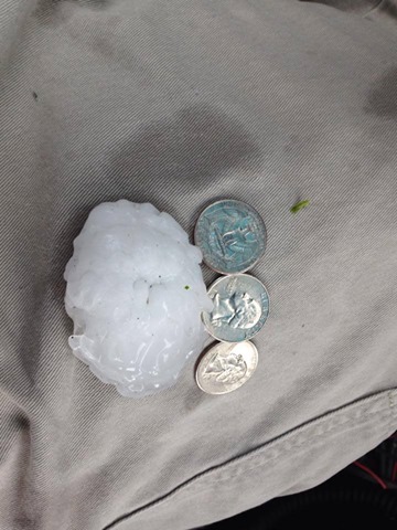
HAZARD…PING PONG BALL SIZE HAIL AND 60 MPH WIND GUSTS.
SOURCE…RADAR INDICATED.
IMPACT…PEOPLE AND ANIMALS OUTDOORS WILL BE INJURED. EXPECT HAIL
DAMAGE TO ROOFS…SIDING…WINDOWS AND VEHICLES. EXPECT
WIND DAMAGE TO ROOFS…SIDING AND TREES.
* LOCATIONS IMPACTED INCLUDE…
ATLANTIC…GREENFIELD…STUART…GRISWOLD…ANITA…ADAIR…
FONTANELLE…LEWIS…CASEY…ORIENT…MASSENA…MENLO…
CUMBERLAND…BRIDGEWATER…MARNE…WIOTA…GRISWOLD PARK…NODAWAY
PARK…LAKE ANITA STATE PARK AND GREENFIELD MUNICIPAL AIRPORT.
THIS INCLUDES INTERSTATE 80 BETWEEN MILE MARKERS 50 AND 95.
PRECAUTIONARY/PREPAREDNESS ACTIONS…
FOR YOUR PROTECTION MOVE TO AN INTERIOR ROOM ON THE LOWEST FLOOR OF A
BUILDING.