United Group Insurance

Rain Delays Start of Girls State Golf Tourney

Sports

May 28th, 2013 by Jim Field

The State Girls Golf Tournament start times will be delayed for Tuesday, May 28th.  Class 1-A/2-A will shotgun start at 12:00 p.m. at American Legion Golf Course in Marshalltown.  Class 3-A/4-A will shotgun start at 12:00 p.m. at Ames Golf & Country Club in Ames.  Class 5-A will shotgun start at 10:00 a.m. at Lake Panorama National Golf Course in Panora.

1-A State Qualifiers:
Corning
Kaleigh Westlake, Corning
Serena Robinette, Griswold

2-A State Qualifiers:
Audubon
Susie Bylund, Audubon
Shelby Williams, CAM/AC
Taylor Gardner, Missouri Valley
Lexie Thygesen, Audubon

3-A State Qualifiers:
Atlantic
Clarinda
Kuemper Catholic
Brooke Fletcher, Atlantic
Bailey Walter, Atlantic
Mara Masching, Kuemper Catholic
Morgan Naberhaus, Kuemper Catholic

4-A State Qualifiers:
Kayla Redeker, Lewis Central

Floodwater strands northwest Iowa couple

News

May 28th, 2013 by Ric Hanson

LE MARS, Iowa (AP) – A northwest Iowa couple have been rescued from their home after it was surrounded by rising floodwater from a nearby creek. Stephanie Luecke told the Sioux City Journal that she and her husband, Ray, had never seen Willow Creek rise so quickly near their home off Iowa Highway 3 on the northeast side of Le Mars. She says the water “surrounded us like an island.”

Water was creeping up the front porch by the time rescue workers arrived at 12:30 p.m. Monday. The Lueckes expect to spend three days at a nearby motel but don’t know what they’ll do next. Stephanie Luecke says she and her husband are wondering what they’d done “to deserve this.”

Officials say Le Mars got nearly 4 1/4 inches of rain over the weekend.

Dark and Stormy nights continue….

News, Weather

May 28th, 2013 by Ric Hanson

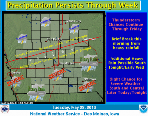
The weather pattern will remain the same for the next several days with chances for additional thunderstorms increasing again later this afternoon and tonight. Some thunderstorms early this morning over Central Iowa may bring some brief heavy rainfall…but the focus will shift to the southern half of the region again tonight as both a threat for heavy rainfall and a slight risk of severe weather returns. A stronger storm will move into the region later Wednesday evening and Thursday keeping thunderstorm chances in the forecast through Friday.

Program aims to help Iowans learn to garden & feed themselves

Ag/Outdoor, News

May 28th, 2013 by Ric Hanson

Gardening is being promoted to Iowans through a new statewide initiative that’s designed to reach out to people who’ve never grown anything as well as current gardeners who might be able to grow a little more to give away. Angie Tagtow is project coordinator for Cultivate Iowa. “We are focusing our efforts on low-resource Iowans to encourage them to think about gardening as a way of not only putting fresh foods on their plates but also saving their food budget and hopefully improving health and food security,” Tagtow says. 

The project also targets existing gardeners, encouraging them to grow more produce and donate it to a nearby food pantry or community group. Gardening doesn’t need to take a lot of time or money, in fact, she says it should save you both commodities. Through gardening, Tagtow says you can keep some green in your pocket while also putting green on your table. “You don’t need to have a back yard to grow a little bit of your own food,” Tagtow says. “If you go to the Cultivate Iowa page and click on the garden link, we’ve got some simple steps in which all of us can do to grow some really wonderful vegetables in containers.” 

In fact, using containers as a garden also means fewer weeds to pull. The website, www.cultivateiowa.org, contains a trove of downloadable information on how to start the process of tilling the soil and growing delicious veggies. “Tomatoes and peppers are great container garden as well as backyard garden plants,” Tagtow says. “Easy to grow, they’re some of the best-tasting vegetables that we have and some of the vegetables that we most often eat here inIowa. So, tomatoes and peppers and greens also do really well whether it’s directly sewn into the ground or in containers as well.” 

To get started, she says, all you really need is a container, potting soil and either seeds or plants. For established gardeners who can grow a little extra to donate, CultivateIowaenables them to make pledges, find nearby organizations that accept fresh produce and track their donations.

(Radio Iowa)

Cardinals call up RHP Victor Marte

Sports

May 28th, 2013 by Ric Hanson

KANSAS CITY, Mo. (AP) – The St. Louis Cardinals recalled right-hander Victor Marte from Triple-A Memphis on Monday. Marte was 1-0 with a 2.78 ERA and 10 saves in 20 games with Memphis. Marte, 32, appeared in 48 games last season with St. Louis, going 3-2 with a 4.91 ERA. He pitched for Kansas City in 2009-10 before being traded to St. Louis in 2011 and has a 6-2 record with a 7.09 ERA in 78 relief appearances in the majors.
 
The Cardinals optioned rookie right-hander Carlos Martinez, who had a 4.50 ERA in seven relief appearances, to Memphis of the Pacific Coast League.

(Podcast) Skyscan Forecast: May 28th 2013

Podcasts, Weather

May 28th, 2013 by Ric Hanson

Here’s the Freese-Notis (podcast) weather forecast for Atlantic & the KJAN listening area, and weather information for Atlantic from KJAN News Director Ric Hanson….

Play

NWS Forecast for Atlantic & the KJAN listening area: Tue., May 28th 2013

Weather

May 28th, 2013 by Ric Hanson

Today: **FLASH FLOOD WATCH UNTIL NOON**  Isolated showers and thunderstorms before 10am, then isolated showers and thunderstorms after 5pm. Cloudy, then gradually becoming mostly sunny, with a high near 82. South southwest wind 5 to 10 mph. Chance of precipitation is 20%.
Tonight: Showers and thunderstorms likely, mainly after 1am. Mostly cloudy, with a low around 66. South wind 7 to 10 mph. Chance of precipitation is 60%. New rainfall amounts between a tenth and quarter of an inch, except higher amounts possible in thunderstorms.

Wednesday: A 50 percent chance of showers and thunderstorms. Mostly cloudy, with a high near 81. Breezy, with a south wind 11 to 20 mph, with gusts as high as 24 mph. New rainfall amounts between a quarter and half of an inch possible.
Wednesday Night: Showers and thunderstorms likely, mainly after 1am. Cloudy, with a low around 66. Breezy, with a south wind 15 to 20 mph, with gusts as high as 24 mph. Chance of precipitation is 70%. New rainfall amounts between a half and three quarters of an inch possible.

Thursday: Showers and thunderstorms likely. Cloudy, with a high near 77. Breezy, with a south wind 15 to 17 mph, with gusts as high as 22 mph. Chance of precipitation is 70%. New rainfall amounts between a quarter and half of an inch possible.
Thursday Night: Showers and thunderstorms likely, mainly before 1am. Mostly cloudy, with a low around 64. Chance of precipitation is 60%. New rainfall amounts of less than a tenth of an inch, except higher amounts possible in thunderstorms.

Friday: A 50 percent chance of showers and thunderstorms. Partly sunny, with a high near 79.
Friday Night: A 30 percent chance of showers and thunderstorms. Mostly cloudy, with a low around 59.

Saturday: Mostly sunny, with a high near 74.

Flash Flood Watch (Update)

Weather

May 28th, 2013 by Ric Hanson

COUNTIES: CRAWFORD-CARROLL-GREENE-AUDUBON-GUTHRIE-DALLAS-CASS-ADAIR-MADISON-ADAMS-UNION-TAYLOR-RINGGOLD…

338 AM CDT TUE MAY 28 2013

…FLASH FLOOD WATCH REMAINS IN EFFECT UNTIL NOON CDT TODAY…

THUNDERSTORMS WILL CONTINUE ACROSS CENTRAL IOWA THROUGH THE EARLY MORNING HOURS. THUNDERSTORMS WILL BECOME MORE SCATTERED THROUGH THE MORNING…HOWEVER STORMS WILL STILL BE CAPABLE OF PRODUCING HEAVY RAINFALL…AND MAY TRACK OVER AREAS WHICH HAVE ALREADY RECEIVED RAINFALL OVERNIGHT. HEAVY RAIN WILL FALL ON ALREADY SATURATED SOIL FROM EARLIER HEAVY RAINFALL EVENTS OF THE WEEKEND AND OVERNIGHT MONDAY. HEAVY RAIN ON SATURATED GROUND WOULD CAUSE FLASH FLOODING FAIRLY QUICKLY AND WOULD BE LIFE THREATENING.

PRECAUTIONARY/PREPAREDNESS ACTIONS…

A FLASH FLOOD WATCH MEANS THAT CONDITIONS MAY DEVELOP THAT LEAD TO FLASH FLOODING. FLASH FLOODING IS A VERY DANGEROUS SITUATION. YOU SHOULD MONITOR LATER FORECASTS AND BE PREPARED TO TAKE ACTION SHOULD FLASH FLOOD WARNINGS BE ISSUED.

Iowa News headlines: Tue., May 28th 2013

News

May 28th, 2013 by Ric Hanson

Here is the latest Iowa news from The Associated Press

DAYTON, Iowa (AP) — State and local investigators expect to meet today to plan the next steps in their search for a missing 15-year-old central Iowa girl. Officers searched the Des Moines River yesterday as they continued looking for Kathlynn Shepard. Police believe she and another girl were abducted a week ago. The other girl escaped.

DES MOINES, Iowa (AP) — Forecasters are predicting flooding problems across much of Iowa as rain keeps falling this week. Three to six inches of rain is expected across the state this week after six to eight inches fell in the past few days. Both Marshalltown and New Hartford are at risk of flooding.

EMMETSBURG, Iowa (AP) — Family members of a two-year-old Emmetsburg boy who drowned during Memorial Day weekend are grappling with his death. Larzen Hanson was one of three children inside a pickup truck that slipped into gear and rolled into Five Island Lake. Relatives and bystanders rescued two of the children, but Larzen remained trapped.

WATERLOO, Iowa (AP) — A group of volunteers in Waterloo is working to create a community garden for Burmese immigrants. The Reverend Ken Stecher says many of the community’s Burmese immigrants have a rural background, and they’ll feel more at home working in the garden. Twenty Burmese families have already signed up for the garden.

Severe Thunderstorm Watch for Fremont/Page Counties is cancelled

Weather

May 28th, 2013 by Ric Hanson

WATCH COUNTY NOTIFICATION FOR WATCH 232/ NATIONAL WEATHER SERVICE OMAHA/VALLEY NE

1202 AM CDT TUE MAY 28 2013

THE NATIONAL WEATHER SERVICE HAS CANCELLED SEVERE THUNDERSTORM WATCH 232 FOR THE FOLLOWING AREAS…IN IOWA THIS CANCELS 2 COUNTIES IN SOUTHWEST IOWA FREMONT & PAGE. THIS INCLUDES THE CITIES OF…CLARINDA…FARRAGUT…HAMBURG…SHENANDOAH…SIDNEY AND TABOR.