

w/ Ric Hanson

Podcast: Play in new window | Download (1.4MB)
Subscribe: RSS

Andrea Farrior and Chris Parks discuss the latest information from the Atlantic Animal Shelter.
Podcast: Play in new window | Download (4.4MB)
Subscribe: RSS
Jim Field talks about giving blood and lists some upcoming donation drives.
Podcast: Play in new window | Download (4.5MB)
Subscribe: RSS
FOR SALE: Candle-Making Equipment for sale. Start a new hobby. Everything you need to make candles – molds, wax, pitchers, pans, and supplies (wick, scent, dye, etc.) – everything but the kitchen stove! Molds of all shapes & sizes – round, square, oval, star, & more. Also molds for dinner taper, votive, and hurricane candles. Includes “how to” book on candle making. Make candles for yourself or as gifts for friends and family. Several hundred dollars of equipment & supplies. $100 for the lot. 243-2415.
GARAGE SALE: Saturday, Oct 5th. Starts 8:00 am. 2104 Chestnut Street in Atlantic. Includes printer, DVR, camera tripod, and miscellaneous.
WANTED: potatoes in the field. Call 712-653-2374.
FOR SALE: High powered car audio system, includes two large 12-inch woofers still in the box and two 1500 watt amplifiers, like new. Asking $200. Also, a Craftsman circular saw, $25. And, a five gallon portable heavy duty air tank, $20. Call 712-304-4998.
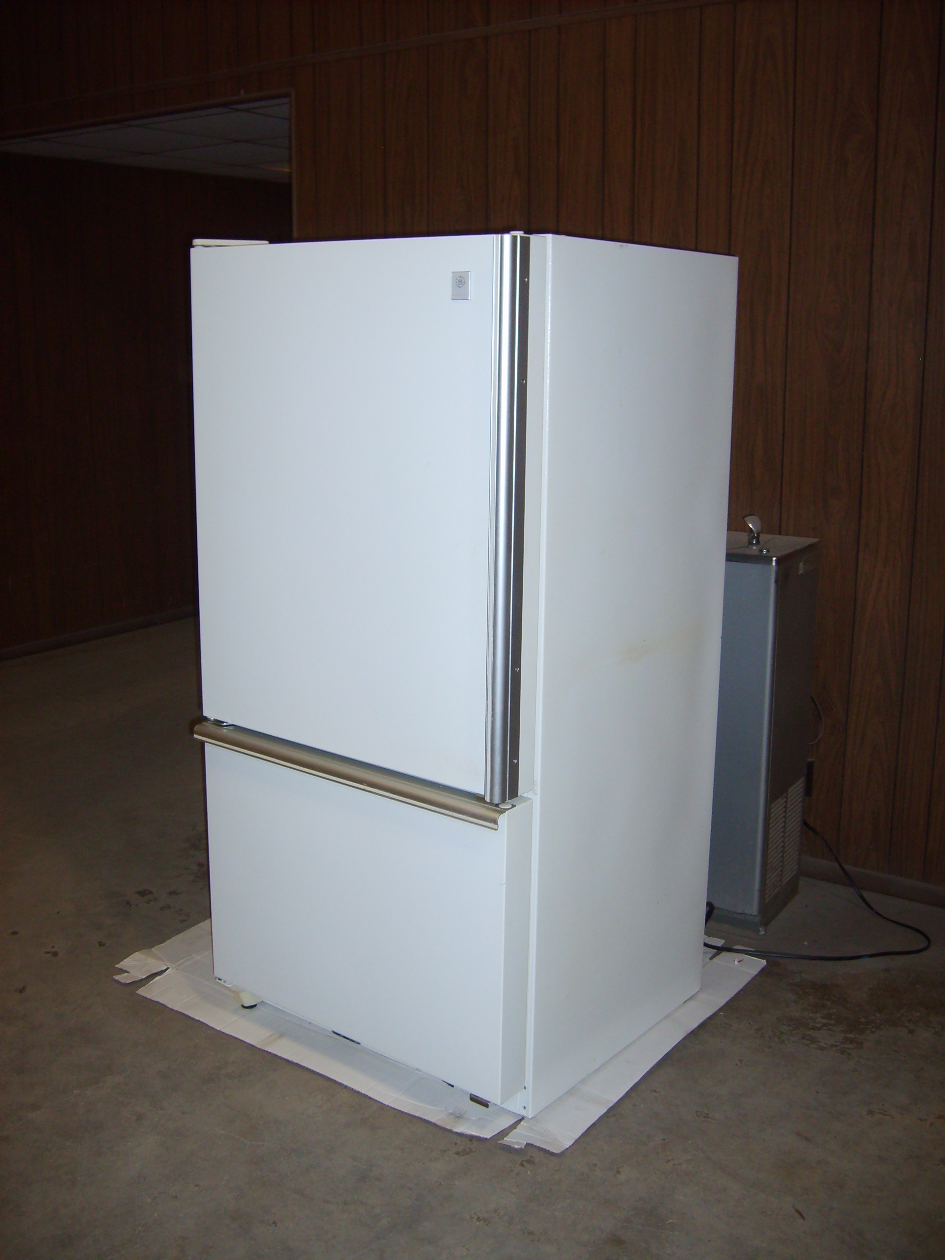
FOR SALE: General Electric Refrigerator-Freezer, 21.7 cubic feet, Model: TCX22ZA, Freezer on bottom with drawer. Good conditions and runs great asking $300.00. Call or text (712)-249-1984 leave message if no answer.
FOR SALE: 8,10,and 12lb dumbbells. Make offer Atlantic. Call 712-314-3095.

WANTED TO RENT: a 1 or 2 bedroom house or apartment in Atlantic or around Exira area. Call 712-314-3095.
FOR SALE: Black & Decker straight and circular guide machine, $150. Black & Decker cement drill, $150. DeWalt table saw, 2 horse power, $200. Call 254-3725.
The National Weather Service says several rounds of thunderstorms are expected across Iowa today through Friday evening. There is a threat for severe weather over central and western Iowa this afternoon and evening with the potential for large hail and damaging winds. An isolated tornado is also possible.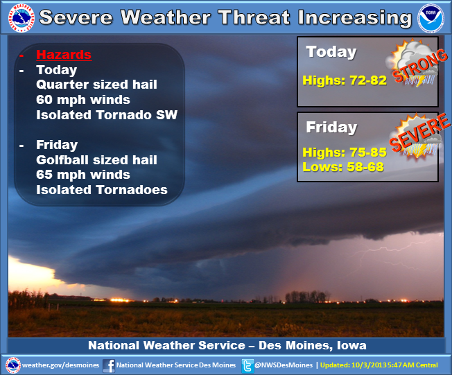 Additional storms are expected to develop over northern Iowa by Friday afternoon. Large hail, damaging winds and a few tornadoes are possible with this activity. One final line of storms will arrive Friday evening and will bring and additional severe weather threat. Storms will end Saturday as much cooler weather arrives. Sunday will remain cool with a few showers forecast over the northern half of the state. Seasonal and mainly dry conditions are expected for the start of next week.
Police in Red Oak report one person was arrested Wednesday night on an assault charge. 30-year-old Paul Silas Ratley, of Fayetteville, NC, was arrested in the 1800 block of East Summit Street, on charges of Simple Domestic Assault, and 5th degree criminal mischief.
Ratley was being held without bond at the Montgomery County Law Enforcement Center.
Lora Kanning, Interpretive Naturalist from the Cass County Conservation and Jim Reimer, Area 6 Representative from the Iowa Waste Exchange will be among the speakers involved in the Food Waste Reduction Workshop on October 15th, at the Council Bluffs Public Library. The workshop will focus on methods to reduce food waste and divert it from the landfill.
Attendees will also hear from Iowa Waste Reduction Center specialists as well as a panel of representatives from area organizations and businesses who will identify the challenges to food waste reduction and diversion. Panelists include representatives from GreenRU, Food Bank for the Heartland, Iowa Western Community College and the Cass County Landfill.
Registration for the one-day workshop is $10, which includes lunch. For more information and to register, visit foodwaste.iwrc.org.
COUNTIES: MONONA-HARRISON-SHELBY-POTTAWATTAMIE-MILLS-MONTGOMERY-FREMONT-PAGE…
TODAY AND TONIGHT: SEVERE THUNDERSTORMS ARE POSSIBLE THIS AFTERNOON…MAINLY ALONG AND NORTH OF INTERSTATE 80. A STATIONARY FRONT WILL BE THE FOCUS FOR THUNDERSTORMS DEVELOPMENT THIS AFTERNOON AS THE ATMOSPHERE BECOME UNSTABLE. THUNDERSTORMS ARE EXPECTED TO CONTINUE INTO THE EVENING HOURS. LARGE HAIL AND DAMAGING WIND WILL BE THE PRIMARY HAZARDS.
FRIDAY: LARGE HAIL…GUSTY WINDS AND ISOLATED TORNADOES ARE ALL POSSIBLE FROM MID FRIDAY AFTERNOON INTO FRIDAY EVENING. SEVERE
THUNDERSTORMS ARE EXPECTED TO DEVELOP FRIDAY AFTERNOON AS A STRONG STORM SYSTEM MOVES INTO THE AREA.
PARTS OF NORTHEAST NEBRASKA AND WEST CENTRAL IOWA COULD SEE THEIR
FIRST FREEZE OF THE SEASON SATURDAY NIGHT INTO SUNDAY MORNING AS
MUCH COLDER AIR DROPS SOUTH.
COUNTIES: SAC-CRAWFORD-CARROLL-AUDUBON-GUTHRIE-DALLAS-CASS-ADAIR-MADISON-ADAMS-UNION-TAYLOR-RINGGOLD
TODAY AND TONIGHT: THUNDERSTORMS ARE EXPECTED ACROSS MUCH OF THE AREA TODAY AND TONIGHT. A FEW SEVERE STORMS ARE POSSIBLE. QUARTER SIZED HAIL AND 60 MPH WINDS ARE THE PRIMARY THREATS. AN ISOLATED TORNADO IS POSSIBLE BETWEEN 3 PM AND 9 PM IN AN AREA WEST OF INTERSTATE 35 AND SOUTH OF HIGHWAY 30.
FRIDAY: ANOTHER ROUND OF STRONG TO SEVERE THUNDERSTORMS IS EXPECTED FRIDAY AFTERNOON NORTH OF HIGHWAY 30 THEN ACROSS THE ENTIRE AREA FRIDAY NIGHT. GOLF BALL SIZED HAIL AND 65 MPH WINDS WILL BE THE PRIMARY THREATS. THERE IS THE POTENTIAL FOR A FEW TORNADOES ESPECIALLY OVER NORTH CENTRAL IOWA FRIDAY AFTERNOON AND ACROSS CENTRAL IOWA LATE FRIDAY AFTERNOON AND EVENING.
SPOTTER INFORMATION STATEMENT… SPOTTER ACTIVATION MAY BE REQUIRED THIS AFTERNOON AND EVENING THEN AGAIN FRIDAY AFTERNOON AND EVENING.
