Residents of southwest Iowa saw everything from heavy rain and hail that covered the roadways, to straightline winds and tornadoes that damaged property, but resulted in no injuries that we’re aware of.
In their storm report issued Wednesday night, the National Weather Service says the Stanton Fire Chief saw a tornado four-miles east of Stanton at around 3:15-p.m., that damaged buildings and vehicles at a rural home. Four-miles south of Riverton, in Fremont County, a funnel cloud was seen at around 2:54-p.m.
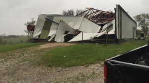
Stanton Tornado damage 4-27-16 (Photo by Stanton Fire Chief)
A weak, rope-style funnel cloud was reported near Highway 25, 5-miles southeast of Bedford (In Taylor County), at around 5-p.m. About 15-minutes later, damage to a barn was reported to have occurred 2-miles north/northwest of Clearfield.
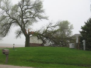
Large tree branch falls during Wednesday’s storm about 2-miles west of the Hwy 92/71 intersection in Cass County. (Ric Hanson/photo)
At around 5:43-p.m., a tornado was observed 3 miles south/southwest of Creston, near the airport, heading toward Creston. By 5:47-p.m, the twister had become rain-wrapped as it was only about one-mile southwest of town. A few minutes later, law enforcement reported another tornado 3 miles north/northeast of Creston.
Five-miles north of Stanton, flooding was taking place at around 6-p.m., with creeks rising out of their banks. An estimated 4.5-inches had fallen during the day as of 7:45-p.m. Wednesday, with a two-day total of 7-inches of rain.
Heavy rain was also observed in the Griswold area Wednesday afternoon, by KJAN News Director Ric Hanson, who also saw dime-sized hail covering a two-mile stretch of Montgomery County Road H-14, between Highway 48 east to County Road M-63, at around 4:20-p.m. Quarter-size hail was reported 5-miles north of Stanton at around 3:25-p.m.
Quarter-size hail was also reported in Essex at around 3:50-p.m. And, nickel-size hail was observed 5 miles southeast of Bedford, at around 4:35-p.m.


