

KJAN News can be heard at five minutes after every hour right after Fox News 24 hours a day!
Keep up-to-date with Fox News Radio, Radio Iowa, Brownfield & the Iowa Agribusiness Networks!

KJAN News can be heard at five minutes after every hour right after Fox News 24 hours a day!
Keep up-to-date with Fox News Radio, Radio Iowa, Brownfield & the Iowa Agribusiness Networks!
Des Moines – Iowa Secretary of State Matt Schultz is encouraging Iowans to vote early today, Tuesday, June 3, for the primary election due to warnings by the National Weather Service and Iowa Homeland Security and Emergency Management of possible severe weather in parts of Iowa later today.
“With the warnings of possible severe weather tonight, I encourage Iowans to vote early today if possible. Safety is the number one priority and county auditors are ready and prepared to take necessary precautions in case severe weather hits,” Schultz said.
In the event of a weather emergency, the first priority is to keep poll workers and voters at the polling place safe. Precinct election officials and voters should either seek shelter or evacuate the polling place as appropriate based on the conditions in their area. As soon as the threat is over, polling places that are temporarily evacuated or closed must be reopened as quickly as possible.
If a polling place loses power for an extended period of time and must be relocated, the Iowa Secretary of State’s office should be consulted and procedures in 721 Iowa Administrative Code 21.1(5) should be followed. Polling place hours may only be extended by federal or state courts for elections in which candidates for federal office appear on the ballot. Should a court extend the hours, provisional ballots will be cast by any person who votes after the regular 9 p.m. poll closing.
Strong to severe thunderstorms are forecast to develop late this (Tuesday) afternoon across far western Iowa and will quickly transition eastward this evening. The storms will have the potential to produce damaging winds in excess of 70 mph, large hail, and isolated rain wrapped tornadoes. The severe threat looks to continue through the late evening hours.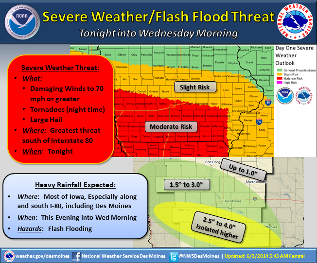
In addition to the severe weather threat, very heavy rain will accompany these thunderstorms. Rainfall rates of 3 to 5 inches per hour are possible along and south of Interstate 80. This is likely to lead to areas of flash flooding where rainfall totals of 2 to 4 inches will be common, with some areas receiving over 5 inches by Wednesday morning. A Flash Flood Watch in is in effect this evening into Wednesday morning across the southern half of Iowa.
State Climatologist Harry Hillaker says Iowa didn’t see as much rain as it normally does during the month of May. “Preliminarily, it looks like May for the most part was a little bit on the warmer side than usual, thanks to a very warm end to the month,” Hillaker says. “And also most of the state was a bit drier than usual, with precipitation averaging out to about an inch and a third or so less than usual.”
Here in Atlantic, at the KJAN studios, we received 3.41-inches of rain. Normal for the month is 4.32. Hillaker says it has been awhile since we’ve seen a May like this. He says it was the “Driest May in eight years, and also the driest spring in nine years.” There was another weather issue of note in May.
Hillaker says “Usually May is a pretty big month for severe weather, didn’t really have a large amount of severe weather, did have some. But overall, a little bit quieter than usual.” The average High for the month of May in Atlantic was 74 (normal is 73). The average Low was 49 (normal is 49). Hillaker says the month of June will be off to a stormy start in Iowa with above normal rainfall and near normal temperatures.
Sheriff’s officials in Montgomery County reports a Red Oak man was arrested Sunday on burglary charges. 22-year-old Kyle Lee Foster was taken into custody after deputies responded to a call pertaining to a man who had entered a vehicle without the owner’s consent. The incident happened in the 1800 block of Summit Street. Foster was being held in the Montgomery County Jail on $5,000 bond.
Police in Red Oak arrested a Pottawattamie County man Monday afternoon. 43-year old Kevin Michael Steadman, of Council Bluffs, was arrested at the Montgomery County Law Enforcement Center on a Red Oak Police Department warrant for Obstruction of Emergency Communications and Domestic Abuse Assault. Steadman was being held in the Montgomery County Jail on $300 bond.
Two people were arrested on separate charges Monday night, in Red Oak. The Police Department reports officers arrested 37-year old Richard Allen Straw, of Red Oak, at the intersection of N. 3rd and Nuckols Streets, for Possession of a Controlled Substance/Marijuana. Straw was also charged with Possession of Drug Paraphernalia and Driving While Suspended. He was taken into custody at around 9:40-p.m. and brought to the Montgomery County Law Enforcement Center, where his bond was set at $2,000.
And, at around11:55-p.m., Red Oak Police arrested 23-year old Kirsten Lynn Wilwerding, of Red Oak. She was found lying in the top floor hallway of an apartment building, allegedly intoxicated. Wilwerding was taken into custody on a charge of Public Intoxication, and brought to the Montgomery County Jail, where she was being held on $300 bond.
417 AM CDT TUE JUN 3 2014
EXTREMELY HEAVY RAIN TONIGHT…IN ADDITION TO THE SEVERE WEATHER THREAT,VERY HEAVY RAIN WILL ACCOMPANY THESE STORMS TONIGHT INTO THE EARLY MORNING HOURS WEDNESDAY. RAINFALL TOTALS WILL RANGE FROM 2 TO 4 INCHES WITH A FEW ISOLATED 5 INCH OR GREATER AMOUNTS POSSIBLE. THE HIGHEST RAINFALL RATES ARE ANTICIPATED TO BE 3 TO 5 INCHES PER HOUR AND MAY LEAD TO AREAS OF FLASH FLOODING.
AREA COUNTIES: AUDUBON-GUTHRIE-DALLAS-CASS-ADAIR-MADISON-ADAMS-UNION-TAYLOR-RINGGOLD …FLASH FLOOD WATCH IN EFFECT FROM 8-PM THIS EVENING THROUGH WEDNESDAY MORNING.
EXCESSIVE RAINFALL RATES OF 3 TO 5 INCHES PER HOUR ARE ANTICIPATED LATE THIS EVENING AND INTO THE OVERNIGHT HOURS. WIDESPREAD TOTAL PRECIPITATION AMOUNTS LOOK TO RANGE FROM 2 TO 4 INCHES BY WEDNESDAY MORNING…BUT COULD SEE ISOLATED AMOUNTS OF 5 INCHES OR GREATER.
* SMALL CREEKS AND STREAMS TYPICALLY SUSCEPTIBLE TO FLASH FLOODING MAY RISE VERY RAPIDLY TONIGHT…ESPECIALLY IN URBAN AREAS.
PRECAUTIONARY/PREPAREDNESS ACTIONS… A FLASH FLOOD WATCH MEANS THAT CONDITIONS MAY DEVELOP THAT LEAD TO FLASH FLOODING. FLASH FLOODING IS A VERY DANGEROUS SITUATION. YOU SHOULD MONITOR LATER FORECASTS AND BE PREPARED TO TAKE ACTION SHOULD FLASH FLOOD WARNINGS BE ISSUED.
351 AM CDT TUE JUN 3 2014
HEAVY RAIN IS EXPECTED LATE THIS AFTERNOON THROUGH THE EVENING. STORMS WILL BRING HEAVY RAIN TO THE REGION BY THIS EVENING DROPPING ANYWHERE FROM 1 TO 3 INCHES OF RAINFALL. THIS COULD LEAD TO AREAS OF FLASH FLOODING.
HARRISON-SHELBY-POTTAWATTAMIE-MILLS-MONTGOMERY-FREMONT-PAGE COUNTIES…FLASH FLOOD WATCH IN EFFECT FROM 7-P.M. TUESDAY THROUGH WEDNESDAY MORNING.
* HEAVY RAIN IS EXPECTED TO DEVELOP BY LATE AFTERNOON OR EARLY EVENING AND CONTINUE INTO THE NIGHT. RAINFALL AMOUNTS OF 1-3 INCHES ARE POSSIBLE.
PRECAUTIONARY/PREPAREDNESS ACTIONS…
A FLASH FLOOD WATCH MEANS THAT CONDITIONS MAY DEVELOP THAT LEAD TO FLASH FLOODING. FLASH FLOODING IS A VERY DANGEROUS SITUATION. YOU SHOULD MONITOR LATER FORECASTS AND BE PREPARED TO TAKE ACTION SHOULD FLASH FLOOD WARNINGS BE ISSUED.


