712 Digital Group - top

Heavy rain pounds part of southwest and central Iowa

News, Weather

August 9th, 2015 by Ric Hanson

Heavy rain prompted officials with the National Weather Service to issue Flash Flood Watches and Warnings late Saturday night and early Sunday morning. Here in Atlantic, we picked up one-half inch of rain at the KJAN studios, overnight. Massena reported 1.31-inches. Those amounts paled in comparison to other parts of southwest Iowa, though. Check out these totals reported to the Weather Service Sunday morning:

  • 3.2 inches in Bedford (Taylor County)
  • 2.71 inches just east of Blockton (Taylor County)
  • 1.45-inches in Clarinda (Page County)
  • 2.95 inches 3 miles west of College Springs (Page County)
  • 1.25 inches 3 miles west of Oakland (Pottawattamie County)
  • 6.85 inches in Randolph (Fremont County)
  • 9.3 inches 2 miles west/southwest of Randolph
  • 5.24 inches 1 miles S/SE of Sidney
  • 3.27 inches in Shenandoah (Page County)

Elsewhere, in Central Iowa 24-hour rainfall (ending at 7-a.m. Sunday) includes: Nevada, with 5.4 inches of rain; Montezuma (Poweshiek County) had 4.80 inches; Near Guernsey (Poweshiek Co.), there was 4.67 inches of rain; The Ames area reported anywhere from just over 3 inches to as much as 4.68 inches of rain; Newton (Jasper County) reported 3 inches; Boone had 2.89 inches; Marshalltown had slightly more than 1.75-inches; and 4.2 inches was reported in Gilbert (Story County).

Flood warnings were issued mid-to late late Sunday morning for southeastern Boone and southwestern Story Counties, where Emergency Management reported flooding in and around the Ames and Nevada areas. And, a Flood Warning was issued for the West Nishnabotna River near Riverton, affecting Fremont County. That warning is in place until further notice or until it is cancelled.

Tournament of Champions First Tee Video

CAM Cougar Channel, Sports

August 9th, 2015 by Jim Field

Check out the action on the first tee at the Tournament of Champions!  The Sunday schedule has golfers starting on the front and back nines, so we will have live video most of the day!

House Fire in Avoca Sunday morning

News

August 9th, 2015 by Ric Hanson

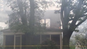
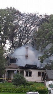
Firefighters from Avoca were called to the scene of a home fully engulfed in flames early this (Sunday) morning. The call for a blaze at the Rod Osbahr residence at 507 N. Chestnut Street, came in at around 1:40-a.m.  Officials say lightening was the apparent cause of the fire, as witnesses reported seeing the home struck not long before the flames erupted. The roof of the structure had reportedly collapsed before fire fighters arrived. Walnut and Harlan Fire provided additional manpower and support.  The house was declared a total loss. No one was home at the time, and no injuries were reported.

Photo's & info. courtesy of James Wolff, from Walnut.

Photo’s & info. courtesy of James Wolff, from Walnut.

Fire1

Work release escape reported from C. Bluffs facility

News

August 9th, 2015 by Ric Hanson

Officials with the Iowa Department of Corrections report an escape occurred Saturday from a work release facility, in Council Bluffs. 28-year old Andrew Eugene Maybee was placed on escape status after failing to return to the facility, Saturday.

Maybee was serving a 25-year prison sentence for two counts of willful injury causing serious injury, conspiracy to commit forcible felony, and going armed with intent. He was transferred to the Council Bluffs facility in June.Maybee

Maybee is a Caucasian male, 6-feet 3-inches tall. He weighs 285 pounds, has blonde hair and blue eyes. He also has a tattoo on his back, and scars on his abdomen, left arm, right forearm, and both hands and legs.

Anyone with information on Maybee’s location should contact Council Bluffs Police.

Grants will help to pay for Pott. County Vet’s bldg.

News

August 9th, 2015 by Ric Hanson

Two grants announced last week address the majority of a $700,000 funding shortfall for the proposed Pottawattamie County veterans building in Council Bluffs. The Omaha World-Herald reports the Iowa West Foundation and Charles E. Lakin Foundation each awarded $275,000 to the project, to help close the gap between the $1.5 million approved by voters more than a year ago and the low project bid of $2.24-million.

The amount not covered by the foundation grants — about $150,000 — will come from county funds that were set aside for a property purchase or through changes in the building’s lighting or other design features to cut costs.

The 6,300-square-foot facility is to be located at the northeast corner of South Sixth Street and Sixth Avenue. The building will house veterans services, replacing the cramped, 1,600-square-foot office space in the Courthouse Annex.


Chiefs’ great Will Shields enters Hall of Fame

Sports

August 9th, 2015 by Ric Hanson

CANTON, Ohio (AP) — Kansas City Chiefs lineman Will Shields has powered his way to football immortality. The 12-time Pro Bowl right guard was inducted into the Hall of Fame on Saturday night. Shields became just the third right guard to enter the Hall.

He made it to Canton in his fourth year of eligibility. The 6-foot-3 Shields joked he’s glad he didn’t grow another couple of inches because if he was taller he might have been moved to tackle and might not have ended up in Canton. Shields was presented for induction by good friend Adrian Lunsford.


Iowa early News Headlines: Sun., Aug. 9th 2015

News

August 9th, 2015 by Ric Hanson

Here is the latest Iowa news from The Associated Press

DES MOINES, Iowa (AP) — A slew of issue-advocacy groups are taking a page from White House hopefuls, flooding airwaves and knocking on doors to try to educate voters ahead of the state’s first-in the-nation 2016 presidential caucus. Groups are running ad campaigns or grassroots efforts are raising issues like early childhood education, campaign finance reform, environmental policy and the national debt. Political strategists and experts view the early-voting state as a fertile ground to reach voters, candidates and influence the conversation. But one veteran operative says that it could be a challenge to cut through the noise because of the mass of groups and candidates jockeying for Iowa voters’ attention.

DES MOINES, Iowa (AP) — Residents in Iowa — and neighboring Nebraska across the Missouri River —took advantage of Iowa’s sales tax holiday this weekend. The annual sales tax holiday coincides with back-to-school shopping. It began Friday and wrapped up Saturday. The Iowa holiday allows shoppers to buy select clothing and footwear priced at less than $100 without paying sales tax or local option taxes.

CEDAR FALLS, Iowa (AP) — An Iowa state auditor’s report says a University of Northern Iowa secretary deposited personal and business checks in lieu of cash donations in an effort to collect personal and business tax breaks. The Des Moines Register reports that auditors found more than $3,000 in cash was collected but never deposited by Lori Shannon, a secretary with the Literacy Education Office.

GARNER, Iowa (AP) — A former Iowa State trooper has been charged with three counts in a child pornography case. The Mason City Globe Gazette reports that 66-year-old David Hubbard of Garner has pleaded not guilty to three counts of misdemeanor sexual exploitation of a minor. Hubbard was arrested on June 30th in Britt.

IOWA CITY, Iowa (AP) — In two seasons as Iowa’s backup quarterback, C.J. Beathard was one of the most popular players on the roster. Beathard, a redshirt junior nicknamed “Sunshine” by his teammates, was promoted to the starting role following a brutal loss to Tennessee in January’s TaxSlayer Bowl. The Hawkeyes open against Illinois State on September 5th.

NWS weather forecast for the KJAN listening area: 8/9/2015

Weather

August 9th, 2015 by Ric Hanson

A FLASH FLOOD WATCH CONTINUES UNTIL 7-A.M. for: DALLAS-ADAIR-MADISON-ADAMS-UNION-TAYLOR-and RINGGOLD COUNTIES…

Early This Morning: Cloudy with scattered thunderstorms. Some thunderstorms may produce heavy rainfall. South wind 5 to 15 mph with gusts to around 25 mph. Chance of thunderstorms 50 percent.

Today: Cloudy with scattered thunderstorms through mid morning… Then mostly cloudy in the late morning and afternoon. Some thunderstorms may produce heavy rainfall through mid morning. High in the lower 80s. Northeast wind 5 to 10 mph. Chance of thunderstorms 40 percent.

Tonight: Mostly cloudy. A 20 percent chance of thunderstorms after midnight. Low in the upper 60s. North wind near 5 mph.

Monday: Partly sunny. A slight chance of thunderstorms in the morning…then a chance of thunderstorms in the afternoon. High around 80. North wind 5 to 10 mph. Chance of thunderstorms 30 percent.

Tuesday: Sunny. High in the lower 80s. North wind 5 to 10 mph.

Wednesday: Sunny. High in the lower 80s.

Urban & small stream Flood Advisory: Page/Fremont Counties

Weather

August 9th, 2015 by Ric Hanson

THE NATIONAL WEATHER SERVICE IN OMAHA HAS ISSUED AN URBAN AND SMALL STREAM FLOOD ADVISORY FOR PAGE COUNTY AND FREMONT COUNTY UNTIL 645 AM CDT.

* AT 342 AM CDT…DOPPLER RADAR INDICATED HEAVY RAIN DUE TO THUNDERSTORMS. THIS WILL CAUSE URBAN AND SMALL STREAM FLOODING IN THE ADVISORY AREA. UP TO THREE INCHES OF RAIN HAVE ALREADY FALLEN.

* SOME LOCATIONS THAT WILL EXPERIENCE FLOODING INCLUDE… CLARINDA…SHENANDOAH…SIDNEY…ESSEX…FARRAGUT…RIVERTON… COIN…TABOR…THURMAN…COLLEGE SPRINGS…SHAMBAUGH…RANDOLPH… YORKTOWN…IMOGENE…HEPBURN…PIERCE RECREATION AREA AND WAUBONSIE STATE PARK.


Flash Flood Warning: Ringgold & Taylor Counties

Weather

August 9th, 2015 by Ric Hanson

433 AM CDT SUN AUG 9 2015

THE NATIONAL WEATHER SERVICE IN DES MOINES HAS ISSUED A

FLASH FLOOD WARNING FOR SOUTHWESTERN RINGGOLD COUNTY AND TAYLOR COUNTY, UNTIL 1030 AM CDT.

* AT 432 AM CDT…DOPPLER RADAR INDICATED A THUNDERSTORM PRODUCING HEAVY RAIN ACROSS THE WARNED AREA. UP TO THREE INCHES OF RAIN HAVE ALREADY FALLEN. FLASH FLOODING IS EXPECTED TO BEGIN SHORTLY.

* SOME LOCATIONS THAT WILL EXPERIENCE FLOODING INCLUDE… BEDFORD…LENOX…NEW MARKET…CLEARFIELD…BLOCKTON…GRAVITY… SHARPSBURG…REDDING…BENTON…CONWAY…MALOY…DELPHOS… ATHELSTAN…LAKE OF THREE FIRES STATE PARK AND BEDFORD MUNICIPAL AIRPORT.

ADDITIONAL RAINFALL AMOUNTS OF ONE INCH ARE POSSIBLE IN THE WARNED AREA.

PRECAUTIONARY/PREPAREDNESS ACTIONS…

BE ESPECIALLY CAUTIOUS AT NIGHT WHEN IT IS HARDER TO RECOGNIZE THE DANGERS OF FLOODING. TURN AROUND…DONT DROWN WHEN ENCOUNTERING FLOODED ROADS. MOST FLOOD DEATHS OCCUR IN VEHICLES.