

The 7:20-a.m. Sportscast w/Jim Field.

Podcast: Play in new window | Download (5.6MB)
Subscribe: RSS

The area’s top news at 7:06-a.m., w/KJAN News Director Ric Hanson
Podcast: Play in new window | Download (4.3MB)
Subscribe: RSS
The Freese-Notis (podcast) weather forecast for Atlantic & the KJAN listening area, and weather information for Atlantic.
Podcast: Play in new window | Download (1.5MB)
Subscribe: RSS
FOR SALE: 1 1/2 year old Maytag dishwasher – portable in Atlantic – 254-0258 / $275.00.
FOR SALE: Cosco Booster Car Seat High Back for 22-80 pounds& height 34”-52”, expiration date December 2024. Used very little. $20.00. Phone: 712-778-4692.
FREE: WE HAVE A BUNCH OF WOOD SHIPPING PALLETS . FREE IF YOU PICK UP. ATLANTIC 712 243 9849.
WANTED: GOOD CLEAN FULL SIZE MATTRESS. ATLANTIC 243 9849.
BAYARD, Iowa (AP) – Emergency officials say flash flooding has covered several roadways in central and southern Iowa. Taylor and Ringgold counties were under flash flood warnings early this (Monday) morning, following rainfall estimated at up to 2 inches from passing storms.
The National Weather Service also has issued flood warnings for parts of Audubon, Boone, Carroll, Dallas and Guthrie counties. Late last night, 4.7-inches of rain that fell between 8-and 10-p.m., was recorded in Coon Rapids. Widespread flooding was reported across northern Guthrie County. All paved roads north of Iowa Highway 141 west of Highway 4 to Coon Rapids are closed, with water still rising in northern Bagley, backing-up from Mosquito Creek. Springbrook State Park was evacuated.
The Iowa DOT reported at around 1:30-a.m. Highway 25 was closed 2 mile east of Bayard due to flooding, with a detour route established around Bayard.
No injuries have been reported.
AREA COUNTIES: CRAWFORD-CARROLL-GREENE-AUDUBON-GUTHRIE-
DALLAS-CASS-ADAIR-MADISON-ADAMS-UNION-TAYLOR-RINGGOLD–
517 AM CDT MON SEP 7 2015
TODAY AND TONIGHT: THUNDERSTORMS CHANCES REMAIN IN THE FORECAST…ESPECIALLY EARLY THIS MORNING SOUTH AND AGAIN TONIGHT CENTRAL AND SOUTH. SOME OF THE STORMS MAY PRODUCE TORRENTIAL RAINS AND POTENTIALLY FLASH FLOODING WITH ONE TO THREE INCHES OF RAIN POSSIBLE…AND A FEW AMOUNTS LOCALLY HIGHER. A FEW STORMS MAY ALSO BE SEVERE TONIGHT WITH DAMAGING WIND AND LARGE HAIL THE PRIMARY THREATS.
A FLASH FLOOD WATCH REMAINS IN EFFECT FOR THE AREA.
TUESDAY THROUGH SUNDAY: THUNDERSTORMS WITH LOCALLY HEAVY RAINS MAY LINGER INTO TUESDAY MORNING. ISOLATED STORMS ARE ALSO POSSIBLE AROUND THURSDAY…AND SUNDAY OR SUNDAY NIGHT. NEITHER SEVERE WEATHER OR HEAVY RAINS ARE EXPECTED
WITH THESE STORMS AT THIS TIME.
.SPOTTER INFORMATION STATEMENT...SPOTTER ACTIVATION MAY BE NEEDED TONIGHT AND INTO EARLY TUESDAY MORNING.
HARRISON-SHELBY-POTTAWATTAMIE-MILLS-MONTGOMERY-FREMONT-PAGE COUNTIES…
500 AM CDT MON SEP 7 2015
TODAY AND TONIGHT: SEVERE THUNDERSTORMS PRODUCING LARGE HAIL AND DAMAGING WINDS ARE POSSIBLE LATER THIS AFTERNOON AND EVENING. HEAVY RAIN IS LIKELY OVERNIGHT…WITH FLASH FLOODING POSSIBLE. A FLASH FLOOD WATCH IS POSTED.
THE COLD FRONT THAT MOVED THROUGH THE AREA AND TRIGGERED
THUNDERSTORMS SUNDAY NIGHT IS FORECAST TO LIFT BACK NORTH INTO
SOUTHEAST NEBRASKA AND SOUTHWEST IOWA LATER TODAY AND TONIGHT. HIGH INSTABILITY AND MODERATE SHEAR WILL CONTRIBUTE TO THE SEVERE STORM POTENTIAL DURING THE LATE AFTERNOON AND EVENING. ALSO…ABUNDANT ATMOSPHERIC MOISTURE COMBINED WITH EXPECTED TRAINING OF THUNDERSTORMS OVERNIGHT WILL LEAD TO HEAVY RAINFALL AND FLASH FLOODING…ESPECIALLY IN AREAS THAT RECEIVED HEAVY RAIN SUNDAY NIGHT.
TUESDAY THROUGH SUNDAY: THERE IS A CHANCE FOR THUNDERSTORMS ON TUESDAY AS AN UPPER LEVEL LOW PRESSURE SYSTEM MOVES THROUGH THE AREA. ISOLATED THUNDERSTORMS ARE AGAIN POSSIBLE TUESDAY NIGHT THROUGH WEDNESDAY NIGHT.
SPOTTER INFORMATION STATEMENT... SPOTTER ACTIVATION MAY BE NEEDED LATER THIS AFTERNOON AND EVENING.
MARK THOMAS, 64, of Coon Rapids, died Sun., Sept. 6th, at Thomas Rest Haven in Coon Rapids. Funeral services for MARK THOMAS will be held 10:30-a.m. Fri., Sept. 11th, at the 1st United Methodist Church in Coon Rapids. Ohde Funeral Home in Coon Rapids has the arrangements.
Visitation will be held on Thursday September 10, 2015, 5:00 PM – 7:00 PM at Ohde Funeral Home, Coon Rapid.
Burial will be in the Union Township Cemetery.
Sheriff’s officials in Montgomery County say a teenager from Adams County was arrested late Sunday night. 17-year old Trevor Ryan Myers, of Corning, was taken into custody at around 11:25-p.m. in the 300 block of 3rd Avenue, in Villisca. Myers faces Possession of a Controlled Substance and Possession of Drug Paraphernalia, charges. He was later released to the custody of a parent.
The Flash Flood Watch that was in effect for most the KJAN listening area until 10-am today has been cancelled, with the exception of Adams Union Taylor and Ringgold Counties. A Flash Flood Watch will be in effect this evening beginning at 7 o’clock and running through 7-a.m. Tuesday, for Cass-Adair-Adams-Audubon-Guthrie-Dallas-Fremont-Harrison-Mills-Montgomery-Page-Pottawattamie-Shelby-Union-Taylor-Ringgold Counties.
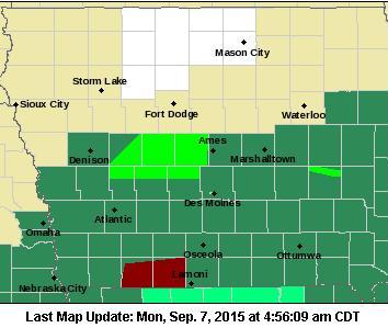
Counties in dark green are under a Flash Flood Watch; Light green: Flood Warning; Counties in dark red: Flash Flood Warning.
The National Weather Service says showers and thunderstorms with potentially heavy flash flooding will continue early this morning, but should diminish toward midday. The overall flash flooding potential will not end by then, however. More showers and thunderstorms with heavy rain are expected again tonight. Rainfall amounts may reach one-to three-inches, with locally higher amounts possible. And, with soils already saturated in many areas, more flash flooding may occur.
A Flood Warning remains in effect until 2-a.m. Tuesday for northern Audubon, Dallas, and Guthrie Counties, along with southeastern Carroll County.
