


A WINTER STORM WATCH REMAINS IN EFFECT FOR SEVERAL COUNTIES IN THE KJAN LISTENING AREA BEGINNING LATE SUNDAY NIGHT OR EARLY MONDAY MORNING. The Watch is in effect from 12-a.m. Monday until 12-a.m. Tuesday for: Harrison, Shelby, Pottawattamie and Mills Counties, and from 6-am Monday until 6-a.m. Tuesday for Cass, Adair, Audubon, Dallas, Guthrie, Crawford, Carroll, and Sac Counties.
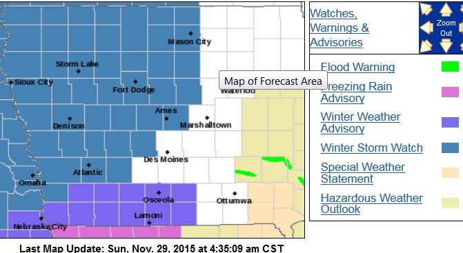
Winter Storm Watch late Sunday night into Monday night (counties in blue). Winter Weather Advisory until 6am Sun. for counties in purple).
For today: Light freezing rain will continue on-and-off across far southeast Nebraska and southwest Iowa this (Sunday) morning. The Main brunt of the storm system will enter the area tonight into Monday and Monday night, bringing a mix of rain…freezing rain…sleet and snow.
The area from Omaha/Council Bluffs to Harlan will see mixed precipitation including icing and /or several inches of snow. Elsewhere in the Winter Storm Watch area, freezing rain will develop later tonight before quickly changing to all snow Monday morning. Additional snowfall and other mixed wintry precipitation of varied intensities will occur later in the day, Monday, before switching to main all lighter snow Monday night or Tuesday.
The National Weather Service predicts anywhere from three-to five-inches of snow will fall in Cass and surrounding Counties, with eight-inches or more further into northwest Iowa. Ice accumulations amounting to several hundredths of an inch may precede the snow.
Winds will shift from the east to southwest Monday, ranging from 5-to 15 miles per hour during the day, with gusts up to 20mph at night. Ice topped by snow will lead to hazardous travel conditions and may possibly impact the Monday morning commute. The heavy, wet snow will also be difficult to shovel and remove.
A WINTER STORM WATCH MEANS THERE IS A POTENTIAL FOR SIGNIFICANT SNOW…SLEET…OR ICE ACCUMULATIONS THAT MAY IMPACT TRAVEL. CONTINUE TO MONITOR THE LATEST FORECASTS.


