

Lavon Eblen speaks with Anne Pellett, Volunteer with Festival of Trees, talking about the event coming up. Still time to decorated a tree and get involved with raffle items.

Podcast: Play in new window | Download (7.5MB)
Subscribe: RSS

Lavon Eblen speaks with Anne Pellett, Volunteer with Festival of Trees, talking about the event coming up. Still time to decorated a tree and get involved with raffle items.
Podcast: Play in new window | Download (7.5MB)
Subscribe: RSS
TORNADO WATCH 534 REMAINS IN EFFECT UNTIL 600 PM CST FOR THE
FOLLOWING AREA COUNTIES…
CARROLL AND SAC
TORNADO WATCH CANCELLED FOR ALL OTHER COUNTIES IN THE KJAN LISTENING AREA.
323 PM CST WED NOV 11 2015
TORNADO WATCH 534 REMAINS IN EFFECT UNTIL 600 PM CST FOR THE
FOLLOWING AREA COUNTIES…
CARROLL AND SAC
TORNADO WATCH CANCELLED FOR ALL OTHER COUNTIES IN THE KJAN LISTENING AREA.
316 PM CST WED NOV 11 2015
…THE TORNADO WARNING FOR NORTHEASTERN GUTHRIE COUNTY IS CANCELLED…THE TORNADIC THUNDERSTORM WHICH PROMPTED THE WARNING HAS MOVED OUT OF THE WARNED AREA. THEREFORE THE WARNING HAS BEEN CANCELLED.
A TORNADO WATCH REMAINS IN EFFECT UNTIL 600 PM CST FOR WEST CENTRAL IOWA.
Intense thunderstorm winds caused a semi to be blown over off Interstate 80 in Cass County and near Avoca in Pottawattamie County, this (Wednesday) afternoon. The accident in Cass County happened just before 2-p.m. The other accident happened at about the same time just west of Avoca. Early reports indicated the injuries appeared to have been minor. A semi was also blown over in Adams County on Highway 34 at around 2:15-p.m.
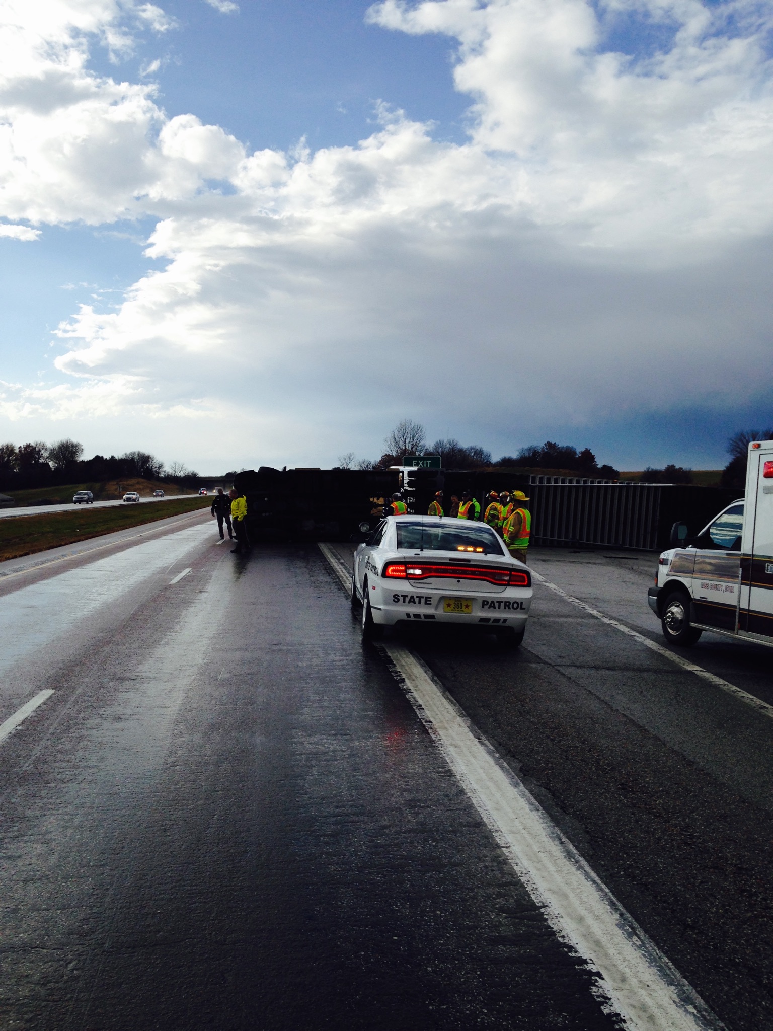
Semi blown over in Cass County (Mike Kennon/Cass County EMA)
Elsewhere, storm damage, apparently created by a tornado or straight-line winds, was reported: Near Avoca; On the west side of Corning (where a employees at an industrial park saw a tornado that damaged trees, roofs and oxygen tanks); Northwest of Maloy (In Ringgold County); A barn lost its roof one mile north of Bridgewater, and numerous power lines were down in Ringgold County, near Delphos.
300 PM CST WED NOV 11 2015
THE NATIONAL WEATHER SERVICE IN DES MOINES HAS ISSUED A
* TORNADO WARNING FOR…
NORTHEASTERN GUTHRIE COUNTY IN WEST CENTRAL IOWA…
SOUTHEASTERN GREENE COUNTY IN WEST CENTRAL IOWA…
* UNTIL 330 PM CST
* AT 300 PM CST…A SEVERE THUNDERSTORM CAPABLE OF PRODUCING A
TORNADO WAS LOCATED NEAR LAKE PANORAMA…OR 8 MILES NORTHEAST OF
GUTHRIE CENTER…MOVING NORTHEAST AT 50 MPH.
HAZARD…TORNADO.
SOURCE…RADAR INDICATED ROTATION.
IMPACT…FLYING DEBRIS WILL BE DANGEROUS TO THOSE CAUGHT WITHOUT
SHELTER. MOBILE HOMES WILL BE DAMAGED OR DESTROYED.
DAMAGE TO ROOFS…WINDOWS AND VEHICLES WILL OCCUR. TREE
DAMAGE IS LIKELY.
* THIS TORNADIC THUNDERSTORM WILL REMAIN OVER MAINLY RURAL AREAS OF
NORTHEASTERN GUTHRIE AND SOUTHEASTERN GREENE COUNTIES…INCLUDING
THE FOLLOWING LOCATIONS…SPRINGBROOK STATE PARK…LAKIN SLOUGH
GAME MANAGEMENT AREA…JAMAICA…BAGLEY…YALE AND RIPPEY.
PRECAUTIONARY/PREPAREDNESS ACTIONS…
TAKE COVER NOW! MOVE TO A BASEMENT OR AN INTERIOR ROOM ON THE LOWEST
FLOOR OF A STURDY BUILDING. AVOID WINDOWS. IF YOU ARE OUTDOORS…IN A
MOBILE HOME…OR IN A VEHICLE…MOVE TO THE CLOSEST SUBSTANTIAL
SHELTER AND PROTECT YOURSELF FROM FLYING DEBRIS.
Four-star prep forward Tyler Cook is among the players who signed with Iowa and coach Fran McCaffery on Wednesday. Cook joins Iowa high school stars Ryan Kriener and Cordell Pemsl in the Hawkeyes latest class. Cook, who is 6-foot-8, is considered among the nation’s top power forwards. Kriener is a 6-foot-9 forward out of Spirit Lake, Iowa.
Pemsl, from Dubuque Wahlert, is also a forward who should help Iowa compensate for losing the likes of Jarrod Uthoff and Adam Woodbury in the post following this season. The Hawkeyes open play Friday by hosting Gardner-Webb.
AMES, Iowa (AP) — Two of the nation’s top junior college stars highlight the recruiting class signed by Iowa State coach Steve Prohm on Wednesday. Prohm signed four players; including junior college standouts Emmanuel Malou and Donovan Jackson.
Malou, a 6-foot-9 forward from Yuba College in California, was the nation’s second-best junior college player by recruiting service 247sports.com He averaged nearly 15 points and 8.5 rebounds last season and turned down Arizona and Kansas to play for Prohm. Jackson, a point guard from Iowa Western, shot 40 percent on 3s last season. Prohm also signed preps Jakolby Long and Solomon Young.
The Cyclones will likely need all four to contribute next season since they lose Georges Niang, Jameel McKay and possibly Monte Morris. No. 7 Iowa State faces Colorado Friday.
252 PM CST WED NOV 11 2015
…THE SEVERE THUNDERSTORM WARNING FOR UNION AND NORTHEASTERN ADAMS COUNTIES IS CANCELLED…
THE STORMS WHICH PROMPTED THE WARNING HAVE MOVED OUT OF THE WARNED AREA. THEREFORE THE WARNING HAS BEEN CANCELLED. A TORNADO WATCH REMAINS IN EFFECT UNTIL 600 PM CST
246 PM CST WED NOV 11 2015
THE NATIONAL WEATHER SERVICE IN DES MOINES HAS ISSUED A
* SEVERE THUNDERSTORM WARNING FOR…
NORTHERN MADISON COUNTY IN SOUTH CENTRAL IOWA…
NORTHEASTERN GUTHRIE COUNTY IN WEST CENTRAL IOWA…
GREENE COUNTY IN WEST CENTRAL IOWA…
WESTERN BOONE COUNTY IN CENTRAL IOWA…
DALLAS COUNTY IN CENTRAL IOWA…
* UNTIL 330 PM CST
* AT 246 PM CST…SEVERE THUNDERSTORMS WERE LOCATED ALONG A LINE
EXTENDING FROM 8 MILES NORTHWEST OF CARROLL TO 7 MILES SOUTHEAST OF
COON RAPIDS TO 7 MILES WEST OF WINTERSET…MOVING NORTHEAST AT 50
MPH.
HAZARD…60 MPH WIND GUSTS AND QUARTER SIZE HAIL.
SOURCE…RADAR INDICATED.
IMPACT…HAIL DAMAGE TO VEHICLES IS EXPECTED. EXPECT WIND DAMAGE
TO ROOFS…SIDING AND TREES.
* LOCATIONS IMPACTED INCLUDE…
WEST DES MOINES…URBANDALE…CLIVE…WAUKEE…GRIMES…PERRY…
JEFFERSON…ADEL…MADRID…OGDEN…DALLAS CENTER…EARLHAM…
GRANGER…PANORA…DE SOTO…WOODWARD…VAN METER…JORDAN CREEK
TOWN CENTER…LAKE PANORAMA AND REDFIELD.
THIS INCLUDES INTERSTATE 80 BETWEEN MILE MARKERS 99 AND 121.
PRECAUTIONARY/PREPAREDNESS ACTIONS…
PREPARE IMMEDIATELY FOR LARGE HAIL AND DAMAGING WINDS. PEOPLE OUTSIDE
SHOULD MOVE TO A SHELTER…INSIDE A STRONG BUILDING AND AWAY FROM
WINDOWS.

