

Jim Field talks about Making Habits Stick.

Podcast: Play in new window | Download (6.4MB)
Subscribe: RSS

Jim Field talks about Making Habits Stick.
Podcast: Play in new window | Download (6.4MB)
Subscribe: RSS
The 7:20-a.m. Sportscast w/Chris Parks.
Podcast: Play in new window | Download (4.6MB)
Subscribe: RSS
The area’s top news at 7:06-a.m., w/KJAN News Director Ric Hanson
Podcast: Play in new window | Download (4.5MB)
Subscribe: RSS
Today: **Winter Weather Advisory in effect**
Cloudy w/periods of snow until about 4pm, then a chance of rain and snow. (1-3 possible in the Atlantic area). High near 34. Winds light & variable.
Tonight: Mostly cloudy, with a low around 20. N @ 5-10.
Christmas Day: Mostly cloudy, with a high near 37. E/SE @ 5-10.
Friday Night: Cloudy w/a 60% chance of rain or drizzle after midnight. Low around 34.
Saturday: Cloudy w/a60% chance of rain or drizzle, mainly before 7am. High near 40. NE @ 10-20.
Saturday Night: Cloudy w/a chance of rain, freezing rain or freezing drizzle. Low near 20.
Sunday: P/Cldy to Cldy & blustery, w/a slight chance of snow and freezing drizzle before 7am. High near 30.
Wednesday’s High in Atlantic was 41. Our 24-hour ending at 7-a.m. today, was 28. We received .53” of from 7-am yesterday thru 7-am today in the form of rain and melted snowfall. Last year on this date we reached 34 for a High and 28 was the low. The All-time Record High in Atlantic on this date was 55 in 1893 & 1964, while the Record Low was -23 in 1983.
The final stretch for hunters to pursue Iowa’s world class deer began Dec. 21st, with the start of the late muzzleloader season and the re-opening of the popular archery season. Both seasons close Jan. 10th. Hunters with a late muzzleloader license may use a bow, muzzleloader, handgun and Iowa residents may also use a crossbow. Hunters may not use a shotgun or centerfire rifles during late muzzleloader season and party hunting is not allowed.
Hunters have reported harvesting nearly 92,000 deer so far this year, which is similar to the harvest last year. Hunters who harvest a deer are reminded to report the harvest to the DNR by midnight on the day after it is tagged or before taking it to a locker or taxidermist, or before transporting it out-of-state, whichever comes first.
For hunters with internet access, reporting online is the easiest and fastest way to report. Hunters may also report their harvest by phone 24 hours a day, seven days a week at the toll-free phone number printed on the harvest tag or through a license vendor during regular business hours.
Nonresident Holiday Season
Nonresidents may participate in the antlerless-deer only holiday season Dec. 24-Jan. 2, in counties where the nonresident antlerless deer quota has not been filled.
Hunters who do not have a nonresident deer license may purchase an optional antlerless-only license for the holiday season. Licenses may be purchased over the counter through any license agent beginning Dec. 15. Holiday deer licenses will not be sold online or through the telephone ordering system.
Nonresident hunters purchased 110 holiday antlerless licenses last year.
CEDAR RAPIDS, Iowa (AP) – Authorities are warning Iowans to beware of Rose Bowl ticket scams. Police in Cedar Rapids say people have reported buying tickets through Craigslist and then meeting the seller at a Cedar Rapids movie theater. The tickets proved to be fakes.
The Marion Police Department says officers are investigating a report of someone driving a car with Washington license plates selling counterfeit tickets. Iowa plays Stanford on New Year’s Day at the Rose Bowl in Pasadena, California.
AREA COUNTIES: MONONA-HARRISON-SHELBY-POTTAWATTAMIE-MILLS–
THE NATIONAL WEATHER SERVICE IN OMAHA/VALLEY HAS ISSUED A WINTER WEATHER ADVISORY FOR SNOW…WHICH IS IN EFFECT FROM 7 AM THIS MORNING TO 2 PM CST THIS AFTERNOON.
A WINTER WEATHER ADVISORY IS ALSO IN EFFECT FROM 8 AM TO 6 PM FOR CASS-ADAIR-AUDUBON-GUTHRIE-DALLAS-CARROLL-CRAWFORD AND SAC COUNTIES, WHERE 2 TO 3 INCHES OF SNOW ARE POSSIBLE TODAY.
* TIMING…SNOW WILL SPREAD ACROSS THE AREA FROM WEST TO EAST THIS MORNING. THE SNOW SHOULD DECREASE OR END BY MID AFTERNOON.
* MAIN IMPACT…SNOW ACCUMULATIONS OF 1 TO 4 INCHES.
* OTHER IMPACTS…TRAVEL DIFFICULTIES.
PRECAUTIONARY/PREPAREDNESS ACTIONS… A WINTER WEATHER ADVISORY MEANS THAT PERIODS OF SNOW…SLEET…OR FREEZING RAIN WILL CAUSE TRAVEL DIFFICULTIES. BE PREPARED FOR SLIPPERY ROADS AND LIMITED VISIBILITIES. USE EXTRA CAUTION WHILE DRIVING.
WINTER WEATHER ADVISORY IN EFFECT TODAY FROM 8-AM TO 6 PM
EARLY THIS MORNING…PARTLY CLOUDY. COLDER. WEST WIND NEAR 5 MPH.
TODAY…PERIODS OF LIGHT SNOW IN THE MORNING…THEN LIGHT SNOW LIKELY AND A SLIGHT CHANCE OF LIGHT RAIN IN THE AFTERNOON. SNOW ACCUMULATION OF 1 TO 2 INCHES. HIGH IN THE MID 30S. SOUTHEAST WIND AROUND 5 MPH SHIFTING TO THE NORTHEAST IN THE AFTERNOON. CHANCE OF PRECIPITATION 90 PERCENT.
TONIGHT…MOSTLY CLOUDY THROUGH MIDNIGHT THEN BECOMING PARTLY CLOUDY. LOW IN THE MID 20S. NORTHWEST WIND NEAR 5 MPH SHIFTING TO THE SOUTHWEST AFTER MIDNIGHT.
CHRISTMAS DAY…MOSTLY CLOUDY. HIGH IN THE UPPER 30S. EAST WIND 5 TO 15 MPH.
FRIDAY NIGHT…CLOUDY WITH A 50 PERCENT CHANCE OF RAIN AND DRIZZLE. LOW IN THE MID 30S. EAST WIND 10 TO 15 MPH.
SATURDAY…CLOUDY WITH A 40 PERCENT CHANCE OF LIGHT RAIN AND DRIZZLE. BREEZY. HIGH IN THE UPPER 30S. NORTHEAST WIND AROUND 10 MPH SHIFTING TO THE NORTH 15 TO 20 MPH IN THE AFTERNOON.
SATURDAY NIGHT...CLOUDY. A SLIGHT CHANCE OF LIGHT FREEZING RAIN…FREEZING DRIZZLE AND LIGHT SNOW THROUGH MIDNIGHT…THEN A SLIGHT CHANCE OF FREEZING DRIZZLE AND LIGHT SNOW AFTER MIDNIGHT. BREEZY…COLDER. LOW IN THE LOWER 20S. CHANCE OF PRECIPITATION 20 PERCENT.
SUNDAY…PARTLY SUNNY. COLDER. HIGH IN THE UPPER 20S.
327 AM CST THU DEC 24 2015
A BURST OF MODERATE SNOWFALL WILL COMPLICATE TRAVEL TODAY. A COMPACT BUT INTENSE STORM SYSTEM WILL CROSS IOWA TODAY, CAUSING SNOW TO FALL FAIRLY HEAVILY FOR A FEW HOURS WITH MODERATE ACCUMULATIONS RESULTING. THIS WILL MAKE TRAVEL HAZARDOUS AT TIMES AS VISIBILITY WILL DROP RAPIDLY AND ROADS WILL BECOME SNOW COVERED.
AREA COUNTIES: SAC-CRAWFORD-CARROLL-AUDUBON-GUTHRIE-DALLAS-CASS-ADAIR…
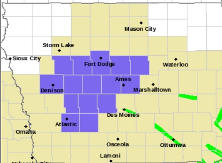
Winter Weather Advisory for Counties shaded in purple.
THE NATIONAL WEATHER SERVICE IN DES MOINES HAS ISSUED A WINTER WEATHER ADVISORY FOR SNOW…WHICH IS IN EFFECT FROM 8 AM THIS MORNING TO 6 PM CST THIS EVENING.
THE HEAVIEST SNOW WILL REACH WESTERN IOWA BY AROUND 8 AM…AND END OVER NORTH CENTRAL IOWA DURING THE AFTERNOON. STORM TOTAL SNOW ACCUMULATIONS OF 2 TO 3 INCHES ARE LIKELY. WINDS WILL BE LIGHT BUT VISIBILITY WILL DROP RAPIDLY TO A MILE OR LESS IN THE HEAVIER SNOW.
TRAVEL CONDITIONS WILL DETERIORATE RAPIDLY AS THE SNOW MOVES IN, WITH VISIBILITY DROPPING RAPIDLY FROM WEST TO EAST BETWEEN MID MORNING AND AROUND MIDDAY. ROADS WILL ALSO BECOME SNOW COVERED AND SLICK. PLEASE RECONSIDER OR ADJUST YOUR TRAVEL PLANS ACCORDINGLY.
PRECAUTIONARY/PREPAREDNESS ACTIONS…
A WINTER WEATHER ADVISORY FOR SNOW MEANS THAT PERIODS OF SNOW WILL CAUSE PRIMARILY TRAVEL DIFFICULTIES. BE PREPARED FOR SNOW COVERED ROADS AND LIMITED VISIBILITIES…AND USE CAUTION WHILE DRIVING.

