

LaVon Eblen visits with Gloria Ross of Mineola about the German Heritage Dinner.

Podcast: Play in new window | Download (5.3MB)
Subscribe: RSS

LaVon Eblen visits with Gloria Ross of Mineola about the German Heritage Dinner.
Podcast: Play in new window | Download (5.3MB)
Subscribe: RSS
The Audubon County Sheriff’s Office reports two, recent arrests. Today (on Monday, 2/8), 57-year old Pamela Jo Steele, of Pittsburgh, KS., turned herself-in to the Sheriff’s Office at around 2-a.m. Steele was wanted on an outstanding warrant out of Audubon County for allegedly violating the terms of her probation. She was being held without bond in the Audubon County Jail, pending an appearance before the magistrate.
And, late last Friday night (Feb. 5th), 42-year old Chad William Darrow, of Audubon, was arrested on an outstanding Audubon County warrant for allegedly violating the terms of his probation. Darrow was being held in the Audubon County Jail on $10,000 bond.
A Blizzard Warning is posted for more than 30 counties across Iowa’s northern half, while much of the rest of the state is under a Winter Weather Advisory. While the term “blizzard” conjures thoughts of deep snow drifts for many Iowans, National Weather Service meteorologist Brad Small says that won’t be the case today.
“People think of blizzards, probably the common definition is associated with a lot of snow,” Small says, “but technically, all it means is that you can’t see where you’re going because of strong winds and low visibilities.” To be a blizzard, winds need to be howling at 35-miles an hour or greater and visibilities need to be at a quarter-mile or less due to blowing snow. Small says new snowfall today will be minimal.
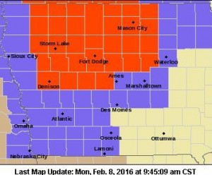
Blizzard Warning for counties in red. Winter Weather and/or Wind Advisories for counties in lavender.
“It’s really difficult to measure,” Small says. “Probably an inch is a very common snow amount so far, of what we’ve seen. The snow amounts are not going to be the problem with this storm. It’s definitely going to be the visibilities, especially in rural and open areas.” Another hazard in this latest weather event is the bitter cold.
“We’ll have wind chills across the state in single digits above and below zero,” Small says. “Conditions will improve later today and into the night but we’ll see lows in the single digits above zero north and maybe around 10 south. Wind chills will be well into the teens below zero toward the Minnesota border by daybreak Tuesday.”
A frosty week is ahead. The forecast calls for low temperatures to remain mostly in the single digits and teens through the weekend, with highs only in the teens and 20s. See more at weather-dot-gov.
(Radio Iowa)
The National Weather Service in Omaha has extended the Wind Advisory which went into effect today at 9-a.m. The Advisory, which had been set to expire at 5-p.m., will now end at 6-p.m. It is in effect for Monona, Harrison, Shelby, Pottawattamie, Mills, Montgomery, Fremont and Page Counties. A Winter Weather Advisory remains in effect until 3-p.m. today for Audubon, Guthrie, Cass, Adair, Adams, Madison, Union, Taylor and Ringgold Counties. And, a Blizzard Warning continues until 3-p.m. for Sac, Crawford and Carroll Counties in the northern part of our listening area.
LIGHT SNOW SHOWERS WILL CONTINUE THROUGH AT LEAST PART OF THE AFTERNOON. HOWEVER…NORTHWEST WINDS OF 25 TO 35 MPH WITH GUSTS TO 50 MPH WILL CONTINUE…CAUSING AREAS OF BLOWING SNOW. CONDITIONS SHOULD IMPROVE BY EARLY EVENING.
RAPID REDUCTIONS IN VISIBILITY ARE LIKELY FROM BLOWING SNOW, ESPECIALLY ALONG WEST TO EAST ROADS. SOME ROADS MAY BE SNOW OR ICE COVERED. THIS WILL MAKE TRAVEL HAZARDOUS.
PRECAUTIONARY/PREPAREDNESS ACTIONS…
A WINTER WEATHER ADVISORY FOR BLOWING SNOW MEANS THAT
VISIBILITIES WILL BE LIMITED DUE TO STRONG WINDS BLOWING SNOW
AROUND. USE CAUTION WHEN TRAVELING…ESPECIALLY IN OPEN AREAS.
Officials with Gronewold, Bell & Kyhnn & Company, PC., have released on audit report on the Cass County Environmental Control Agency. The agency had total revenues of $874,229 for the year ending June 30, 2015. Revenues included solid waste fee of $812,179, and recyclables fees of $55,874.
Expenses totaled $937,843 for the year ending June 30, 2015. They included $59,377 for administration, $129,228 for recycling, and $169, 517 for cover, compacting and scale expense, as well as $56,700 for closure and post-closure costs. In addition, the Agency expended $145,397 for the purchase of equipment and $216,930 to service existing debt.
A copy of the audit report is available for review in the office of the Auditor of State, and the Cass County Environmental Control Agency.
FOR SALE: FTD snowblower, only one year old, pull start, good condition, runs well. Asking $300 OBO. Call 712-789-1330 in Griswold.
FOR SALE: Whirlpool upright freezer, works well. $125. 243-6801 SOLD!!
FOR SALE: Electric heater works fine just don’t use. Looks like a radiator 24″ high. $25.00. Women’s Ariat boots excellent condition size 10. $30.00. Call 641-757-0061.
WANTED: Pickup load of dry firewood. Buyer is able to load and transport firewood. Call 243-2354 Leave message if not at home.
FOR SALE: Small parts washer. Hooks up to an air hose. Asking $40. Call 712-304-4262.
WANTED: Pop-up Camper in decent shape under $2,000. Tanning Bed. Call 712-304-4262.
FOR SALE: 1) Hunter Green reclining chair. Excellent shape with a vibrate feature for the back. $100. 2) Digital Point Micrometer for exact measurements. Comes with case and in is in excellent shape. Asking $100. Call 712-249-4005 in Atlantic.
More area and State news from KJAN News Director Ric Hanson.
Podcast: Play in new window | Download (7.8MB)
Subscribe: RSS
The area’s top news at 7:06-a.m., w/KJAN News Director Ric Hanson
Podcast: Play in new window | Download (5.5MB)
Subscribe: RSS
Today: Winter Weather Advisories for Cass & area Counties until late this afternoon; Blizzard Warning in effect until 3-pm for Sac, Carroll & Crawford Counties. Snow showers this morning & areas of blowing snow thru late this afternoon. High near 24. N/NW @ 25-45. Wind chill values as low as 5. New snow accumulation of less than one inch possible.
Tonight: Cloudy to P/Cldy. Low around 8. N/NW @ 15-30 diminishing late to 10-15 late. Wind chill values as low as -5.
Tuesday: P/Cldy. High near 20. NW @ 10-15 w/gusts to near 25. Wind chill values as low as -5.
Tuesday Night: Partly cloudy, with a low around 4.
Wednesday: Mo. Cldy w/a chance of light snow or flurries. High near 22.
Thursday: Partly Cloudy. High near 22.
Sunday’s High in Atlantic was 41. We received .3 of snow here at the KJAN studios from Sunday afternoon through 7-a.m. today, which amounted to just a Trace of liquid precipitation. The 24-hour Low ending at 7-a.m. today was 19. Last year on this date we reached 43 for a High and 31 was the low. The All-time Record High in Atlantic on this date was 62 in 1954, while the Record Low was -34 in 1971.
