712 Digital Group - top

Enhanced risk of severe storms this evening

News, Weather

July 11th, 2016 by Ric Hanson

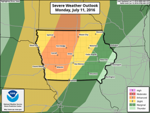
The Severe Storms Prediction Center in Norman, OK., has issued an Enhanced Risk of severe storms across portions of western and central Iowa for storms expected mainly this evening/overnight. Large hail and damaging winds are the main severe threats. Pay attention to the latest forecast for updates through the day/night on KJAN and on our Facebook and Twitter feeds.

SPC

(Podcast) KJAN 8-a.m. News, 7/11/2016

News, Podcasts

July 11th, 2016 by Ric Hanson

More area and State news from KJAN News Director Ric Hanson.

Play

COLE JON ANDERSEN, 46, of Irwin (Svcs. 07-15-2016)

Obituaries

July 11th, 2016 by admin

COLE JON ANDERSEN, 46, of Irwin died Saturday, July 9th at Myrtue Medical Center in Harlan.  Memorial services for COLE JON ANDERSEN will be held Friday, July 15th at 11:00am at Pauley-Jones Funeral Home in Harlan.

Burial will be in the Harlan Cemetery.

Visitation will be held Thursday, July 14th from 8:00-am-to 9:00-pm at Pauley-Jones Funeral Home in Harlan with family greeting friends from 6:00pm-8:00pm that evening.

COLE JON ANDERSEN is survived by:

Daughters: Katy Ponsar of Ottumwa.  Alissa Andersen of Irwin.

Son: Matt Andersen of Harlan.

Brothers: Wade (Dawn) Andersen of Ames.  Scott (Beth) Andersen of Ankeny. Eric (Jami) Andersen of Harlan.

(Podcast) KJAN Morning Sports report, 7/11/2016

Podcasts, Sports

July 11th, 2016 by Ric Hanson

The 7:20-a.m. Sportscast w/Jim Field.

Play

(Podcast) KJAN Morning News & funeral report, 7/11/2016

News, Podcasts

July 11th, 2016 by Ric Hanson

The area’s top news at 7:06-a.m., w/KJAN News Director Ric Hanson

Play

Skyscan forecast & weather data for Atlantic: 7/11/16

Weather

July 11th, 2016 by Ric Hanson

Monday, July 11th 2016 Dan Hicks

 Today: P/Cldy, warm & humid. High 92. SW @ 10-20.

Tonight: P/Cldy to Cldy shwrs & tstrms. (Severe weather is possible) Low 73. S @ 5-10.

Tomorrow: Shwrs & tstrms early; Becoming P/Cldy. High 89. SE @ 10-15.

Wednesday: P/Cldy to Cldy w/scatt. Shwrs & tstrms. High 87.

Thursday: P/Cldy. Less humid. High around 85.

Sunday’s High in Atlantic was 87. Our 24-hour Low thru 7-a.m. today was 72. Last year on this date, our High in Atlantic was 80 and the low was 67. The All-time Record High in Atlantic on this date was 104 in 1936. The Record Low was 43 in 1895.

Iowa authorities search for man who fell into Missouri River

News

July 11th, 2016 by Ric Hanson

BLENCOE, Iowa (AP) – Authorities are preparing to resume their search for a man who fell into the Missouri River. Sioux City television station KCAU reports that the man fell into the water around 7:20 p.m. Sunday near Blencoe. Monona County authorities searched the water and bank until 11:30 p.m. but found no sign of the man.

The man’s name and other information about the incident haven’t been released.

Hazardous Weather outlook for parts of western/southwest IA, 7/11/16

Weather

July 11th, 2016 by Ric Hanson

SAC-CRAWFORD-CARROLL-AUDUBON-GUTHRIE-DALLAS-CASS-ADAIR-MADISON-ADAMS-UNION-TAYLOR-RINGGOLD COUNTIES….

TODAY AND TONIGHT: THUNDERSTORMS ARE EXPECTED TO MOVE ACROSS THE AREA THIS EVENING AND INTO THE OVERNIGHT. A FEW STORMS MAY BE SEVERE WITH DAMAGING WIND GUSTS IN EXCESS OF 60 MPH AND HALF DOLLAR SIZED HAIL. THE STRONGEST STORMS ARE EXPECTED BETWEEN 7 PM AND MIDNIGHT. LOCALLY HEAVY RAINFALL MAY OCCUR.

ADDITIONAL THUNDERSTORMS ARE POSSIBLE TUESDAY AND WEDNESDAY WITH A FEW SEVERE STORMS AND LOCALLY HEAVY RAINFALL POSSIBLE. ADDITIONAL THUNDERSTORMS ARE FORECAST FOR NEXT WEEKEND.

SPOTTER INFORMATION STATEMENT… SPOTTER ACTIVATION MAY BE NEEDED AT TIMES TONIGHT THROUGH WEDNESDAY.

Hazardous Weather Outlook for far west/s.w. IA & eastern NE, 7/11/16

Weather

July 11th, 2016 by Ric Hanson

MONONA-HARRISON-SHELBY-POTTAWATTAMIE-MILLS-MONTGOMERY-FREMONT-PAGE COUNTIES IN IA; MON JUL 11 2016

TODAY AND TONIGHT: SEVERE THUNDERSTORMS ARE POSSIBLE THIS AFTERNOON AND EVENING AS A COLD FRONT MOVES INTO THE AREA. LARGE HAIL…DAMAGING WINDS AND ISOLATED TORNADOES ARE ALL POSSIBLE.

THUNDERSTORMS ARE FORECAST TO DEVELOP IN NORTHEAST NEBRASKA BY MID AFTERNOON…THEN SPREAD SOUTH AND EAST ACROSS THE REST OF EASTERN NEBRASKA AND SOUTHWEST IOWA LATE THIS AFTERNOON AND EVENING. SUFFICIENT INSTABILITY AND SHEAR PARAMETERS WILL EXIST FOR SUPERCELL STORMS THAT WILL BE CAPABLE OF PRODUCING ALL MODES OF SEVERE WEATHER. THE STORMS ARE EXPECTED TO MERGE INTO CLUSTERS OR LINES BY LATE EVENING WHEN TRAINING OF STORMS COULD PRODUCE LOCALLY HEAVY RAINFALL OF GREATER THAN 2 INCHES…LIKELY OVER SOUTHEAST NEBRASKA AND SOUTHWEST IOWA.

THE THREAT OF SEVERE WEATHER SHOULD BE ENDING BY MID EVENING IN
NORTHEAST NEBRASKA…BUT COULD PERSIST PAST MIDNIGHT IN EAST
CENTRAL AND SOUTHEAST NEBRASKA…AS WELL AS ALL OF SOUTHWEST IOWA. BEFORE THE THE RAIN ARRIVES…ANOTHER HOT AND HUMID DAY IS
EXPECTED WITH AFTERNOON HEAT INDEX VALUES INCREASING TO 100 TO 105 DEGREES ALONG AND SOUTH OF INTERSTATE 80.

TUESDAY/WEDNESDAY: THERE IS A CHANCE FOR SEVERE THUNDERSTORMS AGAIN ON TUESDAY AND WEDNESDAY…MAINLY SOUTH OF INTERSTATE 80. THE COLD FRONT MOVING THROUGH MONDAY NIGHT IS FORECAST TO STALL JUST SOUTH OF THE AREA EARLY TUESDAY…THEN SURGE BACK NORTH INTO OUR AREA TUESDAY AFTERNOON AND WEDNESDAY.  ADDITIONAL THUNDERSTORMS ARE POSSIBLE EACH DAY FRIDAY THROUGH
SUNDAY.

SPOTTER INFORMATION STATEMENT: SPOTTER ACTIVATION MAY BE NEEDED THIS AFTERNOON AND EVENING.

Produce in the Park is a “Winner”

Ag/Outdoor, News

July 11th, 2016 by Ric Hanson

The “Farmers Market Scavenger Hunt” is an activity which was offered to all farmers markets by the Iowa Department of Agriculture (IDALS). The purpose is to help kids learn more about locally grown fruits and vegetables and the farmers in their community. Markets could choose to be included.

Youth participants use a form with a list of questions to hunt through the market. What is the smallest fruit or vegetable you see? What is a fruit or vegetable which grows underground? What was your favorite part of the market?  They are also asked to check a list of all of the items they saw and to visit with a farmer.

Produce in the Park has been offering the activity each Thursday evening beginning June 2nd. Completed forms are sent to IDALS twice a month and they are entered in a state drawing for prizes. One local person has been a winner.  Tammy Stotts of IDALS says more entries have been received from Produce in the Park than any other market.  Additional prizes will be available locally.

Kids may participate every week they attend. Forms and pencils are available at the Cass County Food Policy Council table in the center of the Park. Duane McFadden, Council member, is heading up the local activity.