

SEVERE THUNDERSTORM WATCH 372 REMAINS IN EFFECT UNTIL 1100 PM CDT FOR THE FOLLOWING AREA COUNTIES: AUDUBON CARROLL CRAWFORD SAC.

SEVERE THUNDERSTORM WATCH 372 REMAINS IN EFFECT UNTIL 1100 PM CDT FOR THE FOLLOWING AREA COUNTIES: AUDUBON CARROLL CRAWFORD SAC.
WASHINGTON – Sen. Chuck Grassley today (Monday), asked the head of Tyson Foods, Inc., to work with community leaders to restore jobs at the now-defunct Tyson meat processing plant in Cherokee. “I’m aware of the desire of city and county officials to see the facility occupied and operating, so that it can continue to serve the economic and employment needs of the area,” Grassley wrote to Donnie Smith, chief executive officer of Tyson Foods, Inc.
“It is my hope that Tyson Foods would work with the owner of the facility and local leaders in Cherokee to ensure that the facility can be occupied and productive again. It seems there would be mutual interest in seeing the facility occupied to restore economic vitality and livelihoods in their community.”
Grassley noted that when Tyson closed its Cherokee plant in 2014, it eliminated 450 jobs. This was a blow to the local economy, as Tyson was one of the largest employers. According to media reports, the company is locked in a lease with the property owner, and community leaders are frustrated with their inability to seek other employers to lease the facility while the building sits vacant.
“I appreciate your consideration and I look forward to hearing from you,” Grassley wrote.
DES MOINES, Iowa (AP) — Corn and soybean crops in Iowa and Nebraska continue to make good progress and plant development remains ahead of the five-year average for this point in the growing season. The U.S. Department of Agriculture’s weekly crop update says corn in Iowa and Nebraska is rated at nearly 80 percent good to excellent while soybeans are around 78 percent good to excellent.
Storms last week brought rain to both states missing south-central and southeast Iowa and leaving western and southwestern Nebraska without much new moisture. Iowa Secretary of Agriculture Bill Northey says some Iowa farmers have reported isolated crop damage from high wind.
Nebraska farmers reported high wind knocked some corn plants over and snapped off some stalks in a number of eastern counties.
GORDON EDWARD OHM, 90, of Arnolds Park died Sunday, July 10th at his home. Funeral services for GORDON EDWARD OHM will be held on Friday, July 15th at 12:00 pm at the United Church of Avoca. Pauley-Jones Funeral Home in Avoca has the arrangements.
————————————————————————-
Visitation will be held on Thursday from 12:00 pm to 8:00 pm at the funeral home. Family will greet friends Thursday from 5:00 pm to 8:00 pm at the funeral home.
Burial will be held Saturday at 1:00 pm at Westlawn Cemetery in Orange City.
GORDON EDWARD OHM is survived by:
Wife: Gertrude Ohm of Arnolds Park.
Son: Michel Ohm of Okoboji.
345 PM CDT MON JUL 11 2016
SEVERE THUNDERSTORM WATCH 372 IS IN EFFECT UNTIL 1000 PM CDT
FOR THE FOLLOWING LOCATIONS: IOWA COUNTIES INCLUDED ARE
BUENA VISTA CALHOUN CARROLL CHEROKEE CLAY CRAWFORD DICKINSON EMMET HUMBOLDT IDA KOSSUTH LYON O’BRIEN OSCEOLA PALO ALTO PLYMOUTH POCAHONTAS SAC SIOUX WEBSTER WOODBURY.
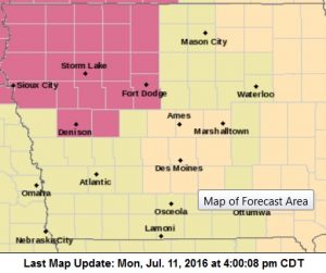
Watch #372. Counties in purple.
* PRIMARY THREATS INCLUDE…
SCATTERED LARGE HAIL AND ISOLATED VERY LARGE HAIL EVENTS TO 2
INCHES IN DIAMETER POSSIBLE.
SCATTERED DAMAGING WIND GUSTS TO 70 MPH POSSIBLE.
A TORNADO OR TWO POSSIBLE.
PROBABILITY TABLE:
PROB OF 2 OR MORE TORNADOES : 20%
PROB OF 1 OR MORE STRONG /F2-F5/ TORNADOES : 05%
PROB OF 10 OR MORE SEVERE WIND EVENTS : 50%
PROB OF 1 OR MORE WIND EVENTS > 75 MPH : 20%
PROB OF 10 OR MORE SEVERE HAIL EVENTS : 40%
PROB OF 1 OR MORE HAIL EVENTS > 2 INCHES : 30%
PROB OF 6 OR MORE COMBINED SEVERE HAIL/WIND EVENTS : 90%
IOWA CITY, Iowa (AP) — University of Iowa students will have the opportunity to include their preferred names and gender pronouns on their school record this fall. The Iowa City Press-Citizen reports that the university became one of the first institutions in the country to allow students to identify as transgender on their admissions application three years ago.
Assistant professor Jodi Lindley said in a video released last week that the change allows students to tell university officials, faculty and staff what name and pronouns they’d like to be used in communication and interactions.
The video includes students, faculty and staff members saying which gender pronouns they preferred for themselves. The majority use either he/him/his or she/her/hers, but others who don’t fit squarely into a male-female binary prefer they/their/theirs or ze/zem/zir.
The Cass County Sheriff’s Office reports two arrests took place over the weekend. On Saturday, 23-year old Joseph Andrew Riesberg, of Elliott, was arrested for OWI 2nd Offense and Driving While Barred. Riesberg was taken to the Cass County Jail where he was released later that day on $2,000 bond.
On Sunday, Cass County Sheriff’s Deputies arrested 43-year old Todd Edward Kimpson, of Corning, on a charge of Violation of a No Contact Order. Kimpson was taken to the Cass County Jail where he was released the today (Monday), on $300 bond.
The Atlantic Police Department says numerous arrests to place over the past week. On Saturday, 21-year old Bryce Baker, of Atlantic, was arrested for Public Intoxication. Friday, 28-year old Robert Mayfield, of Okmulgee, OK., was arrested in Atlantic on a Jasper County warrant for Lottery Ticket Fraud. On July 7th, 27-year old Damion Selders, of Atlantic, was arrested on a Cass County warrant for Burglary in the 3rd degree. Selders was arrested the day before as well, of Possession of a Controlled Substance and Possession of Drug Paraphernalia.
On July 4th, three people were arrested on Cass County warrants. 46-year old Dwane Bolton and 19-year old Lucas Stone, both of Atlantic, were arrested for Failure to Appear. And, 38-year old Rose Peters, of Emerson, was arrested on a warrant for Possession of a Controlled Substance.
On July 1st, 50-year old Thomas Jackson, of Council Bluffs, was arrested in Atlantic after he turned himself-in on a warrant for Parole Violation. All of the subjects mentioned were booked into the Cass County Jail. Jackson later posted bond, and was released.
The Atlantic Police Department has released information on four recent accidents, two of which took place Sunday. In an update to our earlier reports, officials say Devin Register, of Atlantic, was cited for Failure to Obey a Traffic Control Device, following an accident that happened just before 5-p.m., Sunday. Register was traveling eastbound on Highway 6 in a Buick, when he failed to yield at the stop light and collided with a southbound Chevy Suburban driven by Cynthia Koch, of Atlantic. Register complained of pain and was transported by Medivac Ambulance to the Cass County Memorial Hospital. Neither Koch nor a child in her vehicle were hurt. Damage from the crash amounted to $12,100.
A few minutes later, an accident happened at 7th and Elm Streets, when Aubrey Ewing, of Atlantic, failed to stop at the controlled intersection. Her vehicle struck a vehicle driven by Denise Lauritsen, of Exira, as she was traveling east on 7th Street. Ewing was cited for Failure to Obey a Traffic Control Device. Damage from the collision amounted to $2,700.
Last Tuesday evening, vehicles driven by Mandy Parks and Robyn Sullivan, both of Atlantic, collided at 7th and Olive Streets, when Parks failed to obey the stop light as she was traveling west on 7th. Her vehicle struck Sullivan’s vehicle, which was southbound on Olive. Minor injuries were reported by both parties, but no one was transported to the hospital. Damage from the collision amounted to $18,000.
And, on July 5th, a vehicle driven by Debra Williams, of Atlantic, was backing out of a private drive, when it hit a parked car registered to Blain Nolte, of Atlantic. The accident, which happened in the 200 block of Ridge Road, caused $4,000 damage. No citations were issued.
MONONA-HARRISON-SHELBY-POTTAWATTAMIE-MILLS-MONTGOMERY-FREMONT-PAGE-1126 AM CDT MON JUL 11 2016
THIS AFTERNOON AND TONIGHT: SEVERE THUNDERSTORMS ARE PROBABLE THIS AFTERNOON AND EVENING AS A COLD FRONT MOVES INTO THE AREA. LARGE HAIL…DAMAGING WINDS AND ISOLATED TORNADOES ARE ALL POSSIBLE.
THUNDERSTORMS ARE EXPECTED TO DEVELOP IN NORTHEAST NEBRASKA BY MID AFTERNOON…AND THEN ADVANCE SOUTHEASTWARD ACROSS THE REST OF EASTERN NEBRASKA AND SOUTHWEST IOWA LATE THIS AFTERNOON AND EVENING. FAVORABLE INSTABILITY AND SHEAR PARAMETERS WILL BE IN PLACE ALLOWING FOR SUPERCELL DEVELOPMENT BEFORE MERGING INTO A LINE OF STORMS WITH DAMAGING WINDS BECOMING THE PRIMARY HAZARD. IN ADDITION LOCALLY HEAVY RAINFALL OF 2 INCHES OR MORE LIKELY OVER SOUTHEAST NEBRASKA AND SOUTHWEST IOWA.
THE THREAT OF SEVERE WEATHER SHOULD BE ENDING BY MID EVENING IN
NORTHEAST NEBRASKA…BUT COULD PERSIST PAST MIDNIGHT IN EAST
CENTRAL AND SOUTHEAST NEBRASKA…AS WELL AS ALL OF SOUTHWEST IOWA.
BEFORE THE THE RAIN ARRIVES…ANOTHER HOT AND HUMID DAY IS
EXPECTED WITH AFTERNOON HEAT INDEX VALUES OF 100 TO 105 DEGREES
ALONG AND SOUTH OF INTERSTATE 80.
TUESDAY THROUGH SUNDAY: THERE IS A CHANCE FOR SEVERE THUNDERSTORMS AGAIN ON TUESDAY AND WEDNESDAY…MAINLY SOUTH OF INTERSTATE 80. THE COLD FRONT MOVING THROUGH MONDAY NIGHT IS FORECAST TO STALL JUST SOUTH OF THE AREA EARLY TUESDAY…THEN SURGE BACK NORTH INTO OUR AREA TUESDAY AFTERNOON AND WEDNESDAY. ADDITIONAL THUNDERSTORMS ARE POSSIBLE EACH DAY FRIDAY THROUGH
SUNDAY.
.SPOTTER INFORMATION STATEMENT…
SPOTTER ACTIVATION MAY BE NEEDED THIS AFTERNOON AND EVENING.

