

CRAWFORD HARRISON IDA MONONA SAC SHELBY WOODBURY COUNTIES
724 PM CDT THU SEP 15 2016
SEVERE THUNDERSTORM WATCH 476 REMAINS IN EFFECT UNTIL 900 PM CDT

CRAWFORD HARRISON IDA MONONA SAC SHELBY WOODBURY COUNTIES
724 PM CDT THU SEP 15 2016
SEVERE THUNDERSTORM WATCH 476 REMAINS IN EFFECT UNTIL 900 PM CDT
716 PM CDT THU SEP 15 2016
THE NATIONAL WEATHER SERVICE IN OMAHA HAS ISSUED A
* SEVERE THUNDERSTORM WARNING FOR…
NORTHWESTERN SHELBY COUNTY IN SOUTHWESTERN IOWA…
HARRISON COUNTY IN SOUTHWESTERN IOWA…
SOUTHEASTERN MONONA COUNTY IN WEST CENTRAL IOWA…
* UNTIL 800 PM CDT
* AT 716 PM CDT…SEVERE THUNDERSTORMS WERE LOCATED ALONG A LINE
EXTENDING FROM 3 MILES NORTH OF MOORHEAD TO MODALE…MOVING
NORTHEAST AT 25 MPH.
HAZARD…60 MPH WIND GUSTS AND QUARTER SIZE HAIL.
SOURCE…RADAR INDICATED.
IMPACT…HAIL DAMAGE TO VEHICLES IS EXPECTED. EXPECT WIND DAMAGE
TO ROOFS…SIDING…AND TREES.
* LOCATIONS IMPACTED INCLUDE…
LOGAN…MONDAMIN…UTE…PERSIA…MODALE…PISGAH…MOORHEAD…
WOODBINE…DUNLAP…PORTSMOUTH…MAGNOLIA…SOLDIER…CASTANA…
PREPARATION CANYON STATE PARK…
SCHABEN PARK AND WILLOW LAKE RECREATION AREA.
THIS INCLUDES INTERSTATE 29 BETWEEN MILE MARKERS 79 AND 86.
PRECAUTIONARY/PREPAREDNESS ACTIONS…
FOR YOUR PROTECTION MOVE TO AN INTERIOR ROOM ON THE LOWEST FLOOR OF A
BUILDING.
509 PM CDT THU SEP 15 2016
THE NATIONAL WEATHER SERVICE IN OMAHA HAS ISSUED A
* SEVERE THUNDERSTORM WARNING FOR…
SOUTHWESTERN HARRISON COUNTY IN SOUTHWESTERN IOWA…
NORTHWESTERN POTTAWATTAMIE COUNTY IN SOUTHWESTERN IOWA…
SOUTHEASTERN WASHINGTON COUNTY IN EAST CENTRAL NEBRASKA…
* UNTIL 600 PM CDT
* AT 509 PM CDT…A SEVERE THUNDERSTORM WAS LOCATED OVER FORT
CALHOUN… OR 14 MILES NORTH OF OMAHA…MOVING NORTHEAST AT 20 MPH.
HAZARD…PING PONG BALL SIZE HAIL AND 60 MPH WIND GUSTS.
SOURCE…RADAR INDICATED.
IMPACT…PEOPLE AND ANIMALS OUTDOORS WILL BE INJURED. EXPECT HAIL
DAMAGE TO ROOFS…SIDING…WINDOWS…AND VEHICLES. EXPECT
WIND DAMAGE TO ROOFS…SIDING…AND TREES.
* LOCATIONS IMPACTED INCLUDE…
MISSOURI VALLEY…LOGAN…FORT CALHOUN…MONDAMIN…MODALE…
DESOTO BEND NATIONAL WILDLIFE REFUGE…
HISTORICAL VILLAGE WELCOME CENTER AND WILSON ISLAND STATE PARK.
THIS INCLUDES THE FOLLOWING HIGHWAYS…
HIGHWAY 30 IN IOWA BETWEEN MILE MARKERS 1 AND 5.
HIGHWAY 75 IN NEBRASKA BETWEEN MILE MARKERS 108 AND 111.
INTERSTATE 29 BETWEEN MILE MARKERS 68 AND 86.
PRECAUTIONARY/PREPAREDNESS ACTIONS…
FOR YOUR PROTECTION MOVE TO AN INTERIOR ROOM ON THE LOWEST FLOOR OF A
BUILDING.
449 PM CDT THU SEP 15 2016
THE NATIONAL WEATHER SERVICE IN OMAHA HAS ISSUED A
* SEVERE THUNDERSTORM WARNING FOR…
WEST CENTRAL HARRISON COUNTY IN SOUTHWESTERN IOWA…
EAST CENTRAL DODGE COUNTY IN EAST CENTRAL NEBRASKA…
SOUTHEASTERN BURT COUNTY IN EAST CENTRAL NEBRASKA…
NORTHWESTERN WASHINGTON COUNTY IN EAST CENTRAL NEBRASKA…
* UNTIL 530 PM CDT
* AT 449 PM CDT…A SEVERE THUNDERSTORM WAS LOCATED 6 MILES NORTHEAST
OF NICKERSON…OR 29 MILES NORTHWEST OF OMAHA…MOVING NORTHEAST AT
25 MPH.
HAZARD…60 MPH WIND GUSTS AND HALF DOLLAR SIZE HAIL.
SOURCE…RADAR INDICATED.
SEVERE THUNDERSTORM WATCH 476 IS IN EFFECT UNTIL 900 PM CDT
FOR THE FOLLOWING LOCATIONS
.    IOWA COUNTIES INCLUDED ARE

CRAWFORD             HARRISON            IDA
MONONA               POTTAWATTAMIE       SAC
SHELBY               WOODBURY
HARRISON IA-POTTAWATTAMIE IA-DOUGLAS NE-WASHINGTON NE-
448 PM CDT THU SEP 15 2016

...A TORNADO WARNING REMAINS IN EFFECT UNTIL 515 PM CDT FOR
SOUTHWESTERN HARRISON...NORTHWESTERN POTTAWATTAMIE...NORTH CENTRAL
DOUGLAS AND SOUTHEASTERN WASHINGTON COUNTIES...

AT 448 PM CDT...A SEVERE THUNDERSTORM CAPABLE OF PRODUCING A TORNADO
WAS LOCATED 4 MILES SOUTHWEST OF FORT CALHOUN...OR 11 MILES NORTHWEST
OF OMAHA...MOVING NORTHEAST AT 25 MPH.

HAZARD...TORNADO AND GOLF BALL SIZE HAIL.

SOURCE...RADAR INDICATED ROTATION.

IMPACT...FLYING DEBRIS WILL BE DANGEROUS TO THOSE CAUGHT WITHOUT
         SHELTER. MOBILE HOMES WILL BE DAMAGED OR DESTROYED. DAMAGE
         TO ROOFS...WINDOWS...AND VEHICLES WILL OCCUR.  TREE DAMAGE
         IS LIKELY.

THIS DANGEROUS STORM WILL BE NEAR...
  FORT CALHOUN AROUND 500 PM CDT.
  BLAIR AROUND 510 PM CDT.

OTHER LOCATIONS IMPACTED BY THIS TORNADIC THUNDERSTORM INCLUDE DESOTO
BEND NATIONAL WILDLIFE REFUGE AND WILSON ISLAND STATE PARK.

THIS INCLUDES THE FOLLOWING HIGHWAYS...
 HIGHWAY 30 IN IOWA BETWEEN MILE MARKERS 1 AND 5.
 HIGHWAY 30 IN NEBRASKA NEAR MILE MARKER 450.
 HIGHWAY 75 IN NEBRASKA BETWEEN MILE MARKERS 102 AND 114.

PRECAUTIONARY/PREPAREDNESS ACTIONS...

TAKE COVER NOW! MOVE TO A BASEMENT OR AN INTERIOR ROOM ON THE LOWEST
FLOOR OF A STURDY BUILDING. AVOID WINDOWS. IF YOU ARE OUTDOORS...IN
A MOBILE HOME...OR IN A VEHICLE...MOVE TO THE CLOSEST SUBSTANTIAL
SHELTER AND PROTECT YOURSELF FROM FLYING DEBRIS.
335 PM CDT THU SEP 15 2016
…FLASH FLOOD WATCH IN EFFECT THROUGH LATE TONIGHT…
THE NATIONAL WEATHER SERVICE IN DES MOINES HAS ISSUED A FLASH FLOOD WATCH THROUGH LATE TONIGHT FOR MONONA, HARRISON, SHELBY, AUDUBON, SAC, CRAWFORD AND CARROLL COUNTIES IN THE LISTENING AREA.
A COMBINATION OF MODERATE TO HEAVY RAINFALL AND SLOWLY PROGRESSING STORMS THIS EVENING MAY RESULT IN LOCAL RAINFALL AMOUNTS OF 2 TO 4 INCHES OR MORE.
* WATER…STANDING OR FLOWING…MAY MAKE ROADS IMPASSABLE AT TIMES. RAPID RISES ON LOCAL STREAMS AND CREEKS MAY BE SEEN AS WELL.
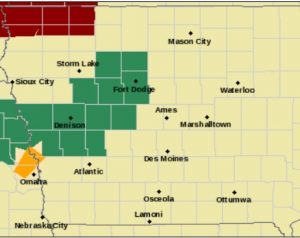
Flash Flood Watch for Counties in green
PRECAUTIONARY/PREPAREDNESS ACTIONS…
A FLASH FLOOD WATCH MEANS THAT CONDITIONS MAY DEVELOP THAT LEAD TO FLASH FLOODING. FLASH FLOODING IS A VERY DANGEROUS SITUATION. YOU SHOULD MONITOR LATER FORECASTS AND BE PREPARED TO TAKE ACTION SHOULD FLASH FLOOD WARNINGS BE ISSUED.
410 PM CDT THU SEP 15 2016
THE NATIONAL WEATHER SERVICE IN OMAHA HAS ISSUED A
* SEVERE THUNDERSTORM WARNING FOR…
SOUTHWESTERN HARRISON COUNTY IN SOUTHWESTERN IOWA…
NORTHWESTERN POTTAWATTAMIE COUNTY IN SOUTHWESTERN IOWA…
DOUGLAS COUNTY IN EAST CENTRAL NEBRASKA…
SOUTHEASTERN WASHINGTON COUNTY IN EAST CENTRAL NEBRASKA…
* UNTIL 445 PM CDT
* AT 410 PM CDT…A SEVERE THUNDERSTORM WAS LOCATED NEAR ELKHORN…OR 10 MILES NORTHWEST OF OMAHA…MOVING NORTHEAST AT 30 MPH.
HAZARD…60 MPH WIND GUSTS AND QUARTER SIZE HAIL.
SOURCE…RADAR INDICATED.
IMPACT…HAIL DAMAGE TO VEHICLES IS EXPECTED. EXPECT WIND DAMAGE TO ROOFS…SIDING…AND TREES.
* LOCATIONS IMPACTED INCLUDE…
WESTERN OMAHA…BLAIR…MISSOURI VALLEY…VALLEY…FORT CALHOUN… WATERLOO…KENNARD…ELKHORN…BENNINGTON…BOYS TOWN… WASHINGTON… DESOTO BEND NATIONAL WILDLIFE REFUGE AND WILSON ISLAND STATE PARK.
THIS INCLUDES THE FOLLOWING HIGHWAYS…
HIGHWAY 275 IN NEBRASKA NEAR MILE MARKER 167.
HIGHWAY 30 IN IOWA BETWEEN MILE MARKERS 1 AND 5.
HIGHWAY 30 IN NEBRASKA BETWEEN MILE MARKERS 441 AND 450.
HIGHWAY 75 IN NEBRASKA BETWEEN MILE MARKERS 99 AND 117.
INTERSTATE 29 BETWEEN MILE MARKERS 66 AND 75.
PRECAUTIONARY/PREPAREDNESS ACTIONS…
FOR YOUR PROTECTION MOVE TO AN INTERIOR ROOM ON THE LOWEST FLOOR OF A BUILDING.
The Atlantic Trojans Football team is hoping to get over the hump this week as they travel to take on the Winterset Huskies. The Trojans have suffered two straight close losses to Shenandoah and Denison-Schleswig and hope they can finish this week to get a win. Head Coach Mike McDermott said an emphasis for his team this week has been to find a way to win.
The Trojans will playing a Winterset team that has the same thoughts on their minds as they have come up just short in their last two games as well, including a 17-13 loss to ADM last week. Coach McDermott knows that the Huskies are a tougher challenge than their 0-3 record suggests.
Atlantic mixed up the offense last week against Denison-Schleswig by moving Jaxson Eden up under center and Garrett Franken out on the edge, which resulted in a big passing touchdown. Coach McDermott knows they will have to pick their spots to try to hit the big play against a strong Huskies defense led by Conner Van Pelt and Noah Larson.
Winterset Head Coach Zach Sweeney talked about establishing the run as being a focus for his team with Running Back Brad Benshoof already carrying the ball 56 times for 296 yard and a score for his team this year. Coach Sweeney also talked about setting the down on defense by shutting down Atlantic’s run game.
Both teams will obviously be hungry to get a win after losing close games last week and Coach Sweeney talked about his team needing to improve in some of the intangible categories to get in the win column.
We’ll have coverage of the Trojans and the Huskies on Friday night on KJAN. Catch our weekly pick ’em show Who’s Gonna Win? at 6:00pm, followed by the Dvorak Tire and Service Pre-Game Show at 6:30pm, and Kickoff will be at 7:30pm. Chris Parks and Mike Smith will have the call on AM1220, FM101.1, online at kjan.com, and on the KJAN app. You can also check out live streaming video on the TV page at kjan.com.
High school students in a northwest Iowa school staged a walk-out on Wednesday after the proposed merger of the Battle Creek-Ida Grove and Odebolt-Arthur School Districts failed. On Tuesday, voters in the Battle Creek-Ida Grove district overwhelmingly voted in favor of the merger, but 57 percent of voters in the Odebolt-Arthur School District voted against it. Terry Kenealy is the superintendent for both districts. He says teachers were going to have some professional development time Wednesday afternoon, so an early dismissal had already been planned for the high school.
“We had become aware that this was going to happen and our principal worked well with the students to try to make sure that it was done in a respectful manner,” Kenealy says. “They walked out to the football field and kind of had a rally and a discussion.” Students who didn’t want to participate left for home or stayed in the school cafeteria. The majority of students, though, chanted, “Ask the students!” as they left the school.
“My impression since I got here is that students for the most part — we’re not perfect, but for the most part — they get along really very well and they’ve enjoyed this experience as a whole-grade sharing school,” says Kenealy, who’s been superintendent for both districts for two years. “There’s many of them that were upset that the vote failed and they feel that students were not the primary concern that people were focused on when they went to vote…They feel like if they’d focused on the students, it would have passed.”
The two districts have had a whole grade sharing arrangement since 2009. High school students in both districts go to school in Ida Grove. Sixth, seventh and eighth graders to go school in Odebolt. There’s also an elementary school in Odebolt and an elementary school in Ida Grove. The superintendent says school boards in both districts will meet next week to discuss what’s next. Kenealy says the Battle Creek-Ida Grove School Board will discuss ending the whole grade sharing agreement with the neighboring district — and that decision must be made by November 1st.
“My point, in my discussion with board members, is students, families and staff members need to know what we’re going to do sooner rather than later because this impacts them more than anybody else,” Kenealy says. “The quicker we can let them know what’s going to happen, the better.” If the school boards decide to seek a second vote on a merger, that can’t happen for at least six months. Critics in Odebolt-Arthur who voted against the merger this week objected to the make-up of the merged school board. They argued it would give too much control to the Battle Creek-Ida Grove side of the district.
About 3900 people live in the Battle Creek-Ida Grove district and about 2000 people live in Odebolt-Arthur’s district. The merged district would have covered 259 square miles and included more than a thousand students.
(Radio Iowa)

