CLICK HERE for the latest market quotes from the Iowa Agribusiness Network!
CLICK HERE for the latest market quotes from the Brownfield Ag News Network!
CLICK HERE for the latest market quotes from the Iowa Agribusiness Network!
CLICK HERE for the latest market quotes from the Brownfield Ag News Network!
DES MOINES, Iowa (AP) — Iowa officials are warning spring paddlers to be wary of cold water and debris piled on by full streams. The state Department of Natural Resources says the water may still be ice cold despite the warm temperatures. They encourage paddlers to have a wetsuit and a change of dry clothes until the water truly warms up.
Recent rains have also caused streams near bank full. Water is flowing fast, and high water has collected debris like trees and limbs. They’ve been deposited at the base of bridge pilings and the outside of tight bends in the river. Officials say good boat control skills and navigation is important to remaining safe while paddling.
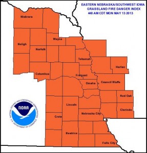
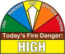
The Shelby County Emergency Management Agency says NO OPENING BURNING is allowed in the County today (Tuesday, May 14th), due to the extremely dry and forecast windy conditions. Officials have bumped the grassland and field fire danger index into the “EXTREME” category for today. The fire danger rating was listed Monday, as “High.”
A Red Flag Warning is in effect for the listening area though late this evening. Officials say Red Flag Warnings are not common in the Midwest, therefore when one is received, the Shelby County Emergency Management Agency will put the Fire Danger index into the Extreme category, and no open burning is permitted.
If you see smoke please report it immediately so fire suppression can take place while the fire is small. For those that find themselves near a fire, explosive fire growth is expected – make sure you are in a safe location and report fires immediately.
DES MOINES, Iowa (AP) — Iowa farmers hope to catch up on field work and get more corn and soybeans planted this week after several weeks of rain delay. Iowa Secretary of Agriculture Bill Northey says in a report released Monday that only 15 percent of the corn crop is in the ground, which is well behind the five-year Iowa average of 79 percent. This is the first spring in 20 years that less than 20 percent of the corn acres were planted by May 12.
Just one-percent of soybeans acres are planted well behind the five-year average of 30 percent. The good news is soil moisture has been replenished with 95 percent of topsoil rated adequate or with a surplus. About 76 percent of Iowa’s subsoil has adequate moisture or a surplus.
COUNTIES: MONONA-HARRISON-SHELBY-POTTAWATTAMIE-MILLS-MONTGOMERY-FREMONT-PAGE–
355 AM CDT TUE MAY 14 2013
…RED FLAG WARNING IN EFFECT FROM 11 AM THIS MORNING TO 9 PM CDT THIS EVENING FOR BREEZY SOUTHWEST WINDS…SOMEWHAT DRY FUELS AND LOW RELATIVE HUMIDITY FOR MUCH OF EASTERN NEBRASKA AND SOUTHWEST IOWA. THE FIRE WEATHER WATCH IS NO LONGER IN EFFECT.
* WIND…SOUTHWEST WINDS WILL INCREASE TO AROUND 15 MPH WITH GUSTS TO 25 MPH OR HIGHER THIS AFTERNOON.
* HUMIDITY…SEVERAL HOURS OF WITH RELATIVE HUMIDITY BELOW 20 PERCENT IS POSSIBLE.
* IMPACTS…ANY FIRES THAT DEVELOP WILL LIKELY SPREAD RAPIDLY. OUTDOOR BURNING IS NOT RECOMMENDED.
PRECAUTIONARY/PREPAREDNESS ACTIONS…
A RED FLAG WARNING MEANS THAT CRITICAL FIRE WEATHER CONDITIONS ARE EITHER OCCURRING NOW…OR WILL SHORTLY. A COMBINATION OF STRONG WINDS…LOW RELATIVE HUMIDITY…AND WARM TEMPERATURES WILL CREATE EXPLOSIVE FIRE GROWTH POTENTIAL.
The Atlantic Area Chamber of Commerce is seeking volunteers to help plant flower beds in the downtown City Park and downtown area. The Atlantic Beautification Team is set to plant flower beds this Thursday, May 16th, at 4 p.m. with the help of their new Adopt-A-Bed Partners and many additional volunteers. Steering committee member Emily Kennedy says they have secured nearly 20 businesses, organizations, 4-H Clubs and individuals to adopt the flower beds and help volunteers to maintain them, but additional volunteers are still encouraged to sign up to help with the planting, as they have in the past.
If you would like to lend a hand, contact the Atlantic Area Chamber of Commerce at 712-243-3017, or e-mail chamber@atlanticiowa.com. Volunteers will be assigned a bed to plant, and will need to sign up in advance to find out the location for planting night. Volunteers are also needed to haul flowers, mulch and equipment during the day preceding the planting. Materials used will be preset at each corner, with help needed in getting those items to the proper location.
Volunteers are encouraged to bring their own shovels, gloves, rakes and any other equipment they like to plant with.
The National Weather Service in Valley, NE, says today’s Grassland Fire Danger Category in eastern Nebraska and southwest Iowa, is Very High. The next two days will be hot and dry, leaving conditions for rapid fire development extremely high. If you plan to burn remember to plan ahead and take all necessary precautions as winds and low humidity levels will create conditions for fast and out of control fires.
The Shelby County Emergency Management Agency says due to forecast low relative humidity and high wind conditions, along with the presence of dry fine fuels, the fire danger rating in the County is being upgraded to HIGH. Controlled burns should be avoided for the next couple of days. Notify your local fire chief if outdoor burning is planned.
Officials are asking participating agencies to place their “Fire Danger” signs in the High category. The rating will be re-evaluated on Thursday, May 16th, or before as conditions dictate.
The Iowa Byways website offers several unique features:
- Customize your search: This is not your ordinary search option. Visitors can search the site by type (event, attraction or travel service); category (arts and culture, dining, events and festivals, historic sites, natural areas, recreation, and shopping); or cost. The search results can be added to the user’s trip; saved as a favorite; or shared using social media.
- Plan your trip details: Sign up for free and then create trips by selecting events, attractions and travel services of interest; or add something from your list of favorites. Once you’ve finished, you can print an itinerary for your trip; share your trip plans via Google Plus™, email or as a tweet; export the information; or save it for later use.
- Share an e-postcard: Choose a postcard photo from one of the byway galleries. Then add a personalized message and email it to a friend or family member.
- Create your favorites list and make notes: Once you’ve discovered an interesting attraction or event on the site, save it as a favorite. Then you can add it to a trip, print a list of your favorites, come back to it later or retrieve the information en route using your smartphone.
You can also order a free copy of the Iowa Byways travel guide, or simply print a copy.
- Plan your bike trip ahead of time: Simply enter the starting address and destination address and a suggested route will be generated.
- Discover Iowa’s bicycle facilities: This interactive map shows bike lanes, paved trails, unpaved trails, roads with paved shoulders, sidepaths and bicycle-friendly roads.
- Locate bicycle amenities: Features such as trailheads, restrooms, and water fountains along trails of 5 miles or longer.
- Need repairs: Bicycle shops are also shown.
You can also request a free Iowa Transportation Map for Bicyclists.
(Press Release)
1016 AM CDT SAT MAY 11 2013
AN AREA OF CANADIAN HIGH PRESSURE WILL SETTLE OVER THE MISSOURI VALLEY BY SUNDAY MORNING. THE COLD AIR ASSOCIATED WITH THE HIGH ALONG WITH CLEAR SKIES AND LIGHT WINDS SHOULD ALLOW FROST TO FORM OVER PARTS OF NORTHERN AND WESTERN IOWA.
AREA COUNTIES: SAC-CRAWFORD-CARROLL-AUDUBON-GUTHRIE-CASS-
…FROST ADVISORY REMAINS IN EFFECT FROM 3 AM TO 9 AM CDT SUNDAY…
* TEMPERATURE…LOWS WILL BE IN THE LOWER 30S.
* IMPACTS…WIDESPREAD FROST WILL THREATEN TENDER VEGETATION IN THE ADVISORY AREA.
PRECAUTIONARY/PREPAREDNESS ACTIONS…
A FROST ADVISORY MEANS THAT FROST IS POSSIBLE. SENSITIVE OUTDOOR
PLANTS MAY BE KILLED IF LEFT UNCOVERED.