KJAN News can be heard at five minutes after every hour right after Fox News 24 hours a day!
Keep up-to-date with Fox News Radio, Radio Iowa, Brownfield & the Iowa Agribusiness Networks!

KJAN News can be heard at five minutes after every hour right after Fox News 24 hours a day!
Keep up-to-date with Fox News Radio, Radio Iowa, Brownfield & the Iowa Agribusiness Networks!
SIOUX CITY, Iowa (AP) – At least two tornadoes were reported near Sioux City, causing extensive property damage. A mile-wide tornado was spotted shortly before 7 p.m. Friday in the northwest town of Moville, in Woodbury County, along with pea-sized hail. Early witness reported indicated that the town had seen major damage.
A second tornado was spotted near Jefferson, S.D., about 10 miles northwest of Sioux City. Local firefighters reported considerable damage in the town, according the National Weather Service.
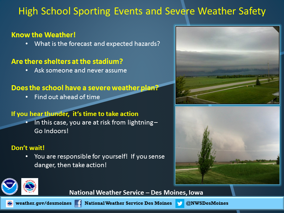
THE NATIONAL WEATHER SERVICE IN DES MOINES SAYS TORNADOES ARE POSSIBLE BY LATE AFTERNOON AND EARLY THIS EVENING IN THE KJAN LISTENING AREA.
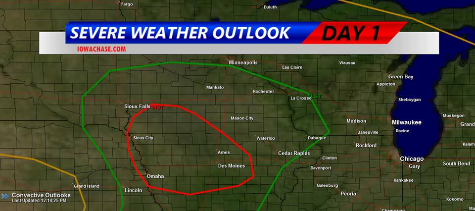
Iowa Storm Chasing Network graphic of Tornadic/Severe Storm threat.
IN THEIR HAZARDOUS WEATHER OUTLOOK ISSUED AT AROUND 12:10-P.M., THE WEATHER SERVICE SAID THERE IS A MODERATE RISK FOR SEVERE WEATHER LATE THIS AFTERNOON THROUGH THE EVENING.
ISOLATED THUNDERSTORMS ARE POSSIBLE THIS AFTERNOON WITH QUARTER SIZED HAIL AND 60 MPH WINDS POSSIBLE. MORE SIGNIFICANT SEVERE STORMS ARE THEN POSSIBLE LATER TODAY DURING THE MODERATE RISK TIME FRAME. VERY LARGE HAIL…GOLF BALL SIZED OR LARGER…70 MPH WINDS AND TORNADOES ARE ALL POSSIBLE. A STRONG TORNADO MAY OCCUR.
A moderate threat of severe weather, including tornadoes, remains in place for later this afternoon and this evening. The threat has shifted slightly to the south and west toward the Missouri River as well. Large hail, damaging winds, locally heavy rains and tornadoes are all possible. Some tornadoes may be strong and long lived.
Folks with early weekend activities, including high school football games, should monitor the weather closely. Have severe weather action plans in place beforehand being ready to seek shelter on short notice.
The Mills County Sheriff’s Department reports four men were arrested Wednesday on Possession of Stolen Property/Theft in the 1st degree, and two counts each of Possession of Stolen Property/Theft in the 2nd degree. The men, all of whom are from Pacific Junction, were identified as: 19-year old Bragun Michael Michaelsen, 33-year old Timothy Eugene Truhlicka, 31-year old Jason Richard Marasco, and 34-year old Adam Michael Michaelsen.
Bragun Michaelsen was arrested at the Mills County Sheriff’s Office, while the other suspects were taken into custody at a location on Depot Street in Pacific Junction. Each was being held in the Mills County Jail on $20,000 bond.
Officials report also, the arrest on Thursday (Oct. 4th), of 49-year old Jack William Yost, of Shenandoah, on charges of OWI/1st offense and Open Container. His bond was set at $1,465. Earlier that same day, 19-year old Robert James Bailey, of Omaha, NE, was arrested in Washington County, NE, on a Warrant for Probation Violation. His bond was set at $10,000.
1153 AM CDT FRI OCT 4 2013
COUNTIES: MONONA-HARRISON-SHELBY-POTTAWATTAMIE-MILLS-MONTGOMERY-FREMONT-PAGE
THIS AFTERNOON AND TONIGHT….
THERE IS A MODERATE RISK FOR SEVERE THUNDERSTORMS OVER PARTS OF EXTREME EASTERN NEBRASKA AND WESTERN IOWA. THERE IS A SLIGHT RISK FOR SEVERE THUNDERSTORMS ACROSS THE REST OF THE OUTLOOK AREA.
THUNDERSTORMS ARE EXPECTED TO INITIALLY DEVELOP IN EASTERN NEBRASKA AFTER 3 PM. THESE THUNDERSTORMS WILL MOVE ACROSS EASTERN NEBRASKA AND INTO WESTERN IOWA THROUGH 7 PM. THE MAIN THREATS INITIALLY FROM THE THUNDERSTORMS WILL BE VERY LARGE HAIL AND DAMAGING WINDS. AS THE LINE OF STORMS PUSHES TOWARD THE MISSOURI RIVER STRONGER INSTABILITY AND WIND SHEAR WILL ENHANCE STORM DEVELOPMENT WITH THE POTENTIAL FOR TORNADO DEVELOPMENT FOR AREAS ALONG THE MISSOURI RIVER INTO WESTERN IOWA.
THE STORMS ARE EXPECTED TO BE FAST MOVING AND PUSH EAST OUT OF THE AREA AFTER 9 PM.
DES MOINES, Iowa (AP) – The Iowa Republican Party is calling planned police traffic checkpoints in western Polk County this weekend unnecessary and are urging motorists who are stopped to comply albeit minimally. The position by the state GOP is being criticized by influential Republican establishment figures as outside the party’s charge.
It marks another in a series of disagreements over strategy between the party’s statewide organization, led by supporters of former Texas Congressman Ron Paul, and longtime party leaders led by Gov. Terry Branstad. State party spokesman Steve Bierfeldt says the police checkpoints announced Friday don’t improve public safety and are a waste of the officers’ time.
Longtime Republican fundraiser and strategist Doug Gross of Des Moines says the party’s statement was “nuts,” and a distraction from the goal of winning elections.
Clarinda Police Chief Keith Brothers, Friday, released a summary of his department’s recent activities, including arrests and incidents. Brothers say on Wednesday, Savannah Ashley Race, of Clarinda, was arrested on a Page County District Court warrant for Conspiracy, Theft in the 2nd degree, and misdemeanor trespass. And, on Tuesday, James Linly Moses, of Shambaugh, was arrested on a Page County warrant for Simple Assault.
Last Sunday, Ronda Jean Jackson, of Clarinda, was arrested for Theft in the 5th degree (shoplifting), and Samantha Ann Wright, of Clarinda, was arrested for Driving While Barred.
The Clarinda P-D also investigated an incident early last week (Sept. 27th), of a male 16-year old allegedly possessing drug paraphernalia. The matter was referred to Juvenile Court. That same day, officers dealt with escape of a 16-year old male from the Clarinda Academy. And, on Oct. 3rd, a Clarinda resident reported an incident of arson which resulted in the destruction of her property located in the 500 block of South 10th Street.
An annual fundraiser for the Defiance Fire Department will be held this weekend at the fire hall. The Defiance Fire and Rescue Department is hosting their pancake breakfast from 8am to noon on Sunday. Fire chief Al Wilwarding says they will kick off Fire Prevention week by serving up a delicious breakfast.
“We’re kicking it off with a pancake, sausage, biscuits and gravy and scrambled egg breakfast. There will be juice and coffee all for a free will donation. Everybody is very invited to come. We do have carry-outs available.” He says the whole breakfast is all homemade. “We crack and scramble our own eggs. We make our own pancake mix. We have a company that donates a hog and we process it into sausage and then we grill it outside to make it extra good.”
The money donated will go towards the Defiance Fire Department to upgrade equipment.
(Joel McCall/KNOD)
This coming week is the start of National Fire Prevention Week but one Shelby County Fire Department is kicking it off this Saturday. The theme this year is preventing kitchen fires. The Harlan Fire Department has teamed up with the American Red Cross to help spread the word about fire prevention week. Harlan Fire Chief Roger Bissen says the department is getting a little help from the boy scouts to hand out fire prevention materials.
“The Red Cross is providing the materials and we are working with the boy scouts. The boy scouts do the leg work and will go to each house in Harlan and dropping off the materials at your doorstep. It will come in a little bag that says Red Cross. Inside there will be different fire safety literature and I will provide a cover letter. If you want to make some changes in your home after reading the material, now is the time to do it.”
Bissen says the project with the Red Cross benefits everyone including the citizens. “We’re sending out the safety message out to our community and you know our goal as the fire department is to prevent fires. It’s also a good project for the Red Cross because they are involved with the safety and well being of our citizens. And it works really well for the boy scouts because they are always trying to reach goals to get awards and achievements. They also get involved in the community. It is really a good community event for everybody.”
The chief says next week the department will be at the Harlan Community schools. “Each we head to the schools and give tours at the fire station. We have three to four groups come to the station. We will also send trucks to the elementary schools. We will be there quite a few days from Monday through Thursday.”
This is also the time of year to be checking your smoke detectors to make sure they are working properly. The Harlan Fire Department received a grant for about 200 smoke detectors and if you are unable to purchase a new one or do not have any inside your residence, contact the Harlan Fire Department at 712-755-5354. If you would like to talk with one of the 34 members of the department, the Harlan Fire Department will host an open house and breakfast on Sunday morning. The fire hall will open at 7am and serve biscuits and gravy, eggs, pancakes, bacon and a drink for a free will donation until noon.
(Joel McCall/KNOD)
The Iowa Storm Chasing Network says a “Very dangerous situation” could be in the works for this afternoon and this evening, where the development of destructive tornadoes is concerned. The enhanced risk exists over a large portion of Iowa.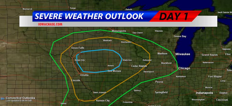
Thunder and lightning awakened many Iowans this morning (Friday) as a potent, large storm system began to bear down on the state. Numerous thunderstorm watches and warnings were issued in the wee hours. Meteorologist Brad Small, at the National Weather Service, says the next several hours will be an active period for weather across much of the state. “The potential is still there for more activity later in the day,” Small says. “There’s a moderate risk of severe weather over northern Iowa and into parts of central Iowa. That would mean all kinds of severe weather, large hail, damaging winds and tornadoes are all possible in that area.” To the west, Small says it’s much less like early fall and much more like the dead of winter as Blizzard Warnings and Winter Storm Watches are in effect in South Dakota, Nebraska, Colorado and Wyoming.
“There’s heavy snow in the Black Hills, thankfully we’ll miss out on that but temperatures will be sharply colder by tomorrow,” Small says. “It’s a big change from what we’ve seen the past few days. Highs will only be in the 50s and 60s.” Iowans can count their blessings as some states to the west have a forecast that includes 12 to 20-inches of snow and strong winds, bringing white-out conditions.
(Radio Iowa/Iowa Storm Chasers Network)