712 Digital Group - top

Heavy rains, flooding causing park closures across Iowa

Ag/Outdoor, News

May 26th, 2019 by Ric Hanson

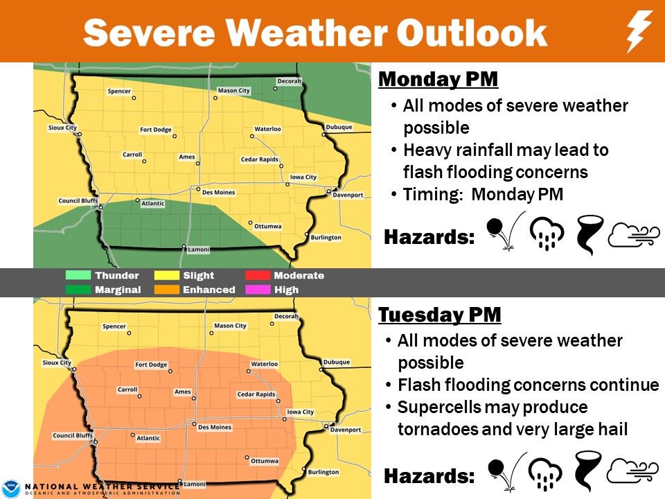
DES MOINES, Iowa – Officials with the IA DNR said Sunday, that rising river levels caused by heavy rainfall lately is forcing some state parks to be closed this Memorial Day weekend.

LEDGES: The Canyon Drive at Ledges State Park is currently closed to vehicle traffic due to flash flooding. The Lower Ledges Road and adjacent parking lots are also currently closed to vehicle traffic due to rising Des Moines River water levels. A significant rise in Saylorville Reservoir pool levels is also forecast, which will likely prolong closures of both the Canyon Drive and Lower Ledges Road into the foreseeable future. Visitors are still welcome to hike in Ledges State Park, though, as all of the trail system remains open. Parking for vehicles is available at the Oak Woods Picnic Area, Lost Lake Trail head, and several other upper area parking lots. Both of the open shelters and the campground at Ledges State Park remain open and accessible by vehicle.

GEORGE WYTH: George Wyth State Park closed Saturday, May 25, due to flooding. With the forecasted rainfall for Sunday night into Monday, the park will likely remain closed through the first part of the week.

FAIRPORT RECREATIONAL AREA: All campsites at Fairport Recreation Area are closed due to flooding from the Mississippi River.

DOLLIVER: Dolliver State Park will close at 3:30pm today, May 26, due to rising river levels and forecasted rainfall expected on Sunday night into Monday. DNR Staff has contacted park users currently on-site and those that have reservation for the near future.

For the very latest on state parks and trail closures across the state, visit: https://www.iowadnr.gov/Places-to-Go/State-Parks/Alerts-and-Closures

Omaha man dies from Pott. County motorcycle accident

News

May 26th, 2019 by Ric Hanson

Pottawattamie County Sheriff Jeff Danker reports a Nebraska man involved in a motorcycle accident this weekend, has died from his injuries. Deputies responded at around 6-p.m. Saturday, May 25th, to Old Lincoln Highway near the intersection with Teal Lane for a motorcycle accident.

Upon arrival, deputies located the driver, 68-year old Paul Lund, of Omaha, suffering from serious injuries. Lund was transported by helicopter to a local area hospital.  Mr. Lund was later pronounced dead.

Authorities determined Lund was southbound on Old Lincoln Highway on a 2003 Indian motorcycle, when near the intersection with Teal Lane, he lost control of his machine. No one else was on board the cycle.

Ex-Iowa teacher convicted in student sex abuse case

News

May 26th, 2019 by Ric Hanson

GLENWOOD, Iowa (AP) — A former western Iowa art teacher and track coach accused of groping and having other sexual contact with a female student has been convicted of two counts.

Prosecutors in Mills County say a jury convicted 40-year-old Christopher Lee Irvin, of Pacific Junction, on Friday of third-degree sexual abuse and sexual exploitation by a school employee. Irvin is being held without bond until his sentencing at a later date, when he faces up to 12 years in prison.

A girl reported that Irvin groped her earlier last summer and had other sexual contact with her earlier in the year. The criminal complaints say the incidents did not occur on school property.

Irvin had worked for the East Mills School District in western Iowa.

WA State man arrested on escape charge in Taylor County

News

May 26th, 2019 by Ric Hanson

The Taylor County Sheriff’s Office reports a Washington State man was arrested Saturday on an escape charge. 22-year old John Walker, of Goldendale, WA, was arrested in the 200 block of Pearl Street in Bedford, on a active warrant from the Washington State Department of Corrections, for Escape from Custody on an original charge of Possession of a Controlled Substance.

Walker was being held at the Taylor County Sheriff’s Office until he is extradited to the state of Washington.

Be Weather Aware this week! Large dangerous storms possible

News, Weather

May 26th, 2019 by Ric Hanson

The National Weather Service reports strong to severe storms are looking increasingly possible both Monday afternoon/evening and Tuesday afternoon/evening. For both days, all modes of severe weather appear to be possible- including tornadoes, large hail, damaging winds, along heavy rainfall that may lead to flash flooding concerns.

In particular, at this time, Tuesday’s severe weather may be significant. There may be supercells that spawn tornadoes and very large hail. Please monitor the weather forecasts closely, especially if you have outdoor plans Monday afternoon-evening and/or Tuesday afternoon-evening.

NWS forecast for Atlantic & the area: 5/26/2019

Weather

May 26th, 2019 by admin

Today: A 20 percent chance of showers and thunderstorms before 7am. Partly sunny, with a high near 78. Northeast wind around 8 mph becoming east southeast in the afternoon.
Tonight: Showers and thunderstorms, mainly after 11pm. Low around 63. East southeast wind 8 to 11 mph, with gusts as high as 18 mph. Chance of precipitation is 100%. New rainfall amounts between a half and three quarters of an inch possible.
Memorial Day: Showers and thunderstorms, mainly before 1pm. High near 80. Breezy, with a southeast wind 13 to 16 mph becoming south southwest in the afternoon. Winds could gust as high as 28 mph. Chance of precipitation is 80%. New rainfall amounts between a quarter and half of an inch possible.
Monday Night: A 50 percent chance of showers and thunderstorms. Mostly cloudy, with a low around 63. South wind 7 to 10 mph. New rainfall amounts between a tenth and quarter of an inch, except higher amounts possible in thunderstorms.
Tuesday: Showers and thunderstorms likely, mainly after 1pm. Mostly cloudy, with a high near 79. South wind 9 to 14 mph, with gusts as high as 21 mph. Chance of precipitation is 60%. New rainfall amounts between a quarter and half of an inch possible.
Tuesday Night: A 50 percent chance of showers and thunderstorms, mainly before 1am. Mostly cloudy, with a low around 57. New rainfall amounts between a tenth and quarter of an inch, except higher amounts possible in thunderstorms.
Wednesday: A 30 percent chance of showers and thunderstorms after 1pm. Partly sunny, with a high near 70.

Yesterday’s High in Atlantic was 81. Our Low was 57. As of 6-a.m. Today, we had received .28” of rain here at KJAN. Last year on this date our High was 100 and the Low was 61. The record High in Atlantic on this date was 100 in 2018. The Record Low was 30 in 1901.

St. Albert’s Miller, Denison duo place at State Boys Tennis

Sports

May 26th, 2019 by admin

St. Albert’s Reed Miller and Denison’s doubles team of Colin Reis and Sean Moran placed at Boys State Tennis that finished up on Saturday.

Miller won both of his matches on Saturday in the consolation bracket and took 5th place. Miller topped Jordan Roozeboom of Pella 4-6, 7-5, 1-0 (9) to move into the 5th place match. In the 5th place match he won 6-3, 7-5 over Rhett Peters of Union.

Denison-Schleswig’s Colin Reis and Sean Moran placed 6th in doubles play. The duo beat Winterboer/Wohlgemuth of Ballard in the consolation semifinals 7-6 (2), 7-6. They then lost the 5th place match to Cedar Rapids Xavier’s Horstmann/Courter 6-7 (2), 6-2, 1-0 (6).

Boys Substate Soccer Scoreboard 05/25/2019

Sports

May 26th, 2019 by admin

Class 1A

Substate 8
Greene County 5, AHSTW 2

Class 2A

Substate 8
Lewis Central 4, Harlan 0

Substate 7
Dallas Center-Grimes 3, ADM 1

High School Baseball and Softball Scoreboard 05/25/2019

Sports

May 26th, 2019 by admin

Baseball

Johnston 17, Lewis Central 2 (4 innings)
Lewis Central 8, Boone 2
Logan-Magnolia 6, Lawton-Bronson 3
Logan-Magnolia 14, Lawton-Bronson 3
Treynor 12, Shenandoah 2
Treynor 12, Shenandoah 4

Softball

ADM 11, Van Meter 1
Boone 12, Glidden-Ralston 0
Martensdale-St Marys 13, Glidden-Ralston 1
Southeast Valley 6, Glidden-Ralston 2
Boone 13, Martensdale-St Marys 3

Boone 5, Southeast Valley 4
Carroll 7, Greene County 3
Carroll 8, Webster City 3
Chariton 2, Coon Rapids-Bayard 1
Fort Dodge 12, Lewis Central 0
Hinton 10, Logan-Magnolia 4
Harlan 5, Van Meter 3
Interstate 35 5, Harlan 3

MVAOCOU 10, Hinton 5
Ogden 3, Carroll 0
Twin Cedars 10, West Central Valley 0

Prescott woman arrested on an Assault charge Sunday morning

News

May 26th, 2019 by Ric Hanson

Sheriff’s officials in Adams County report Josephine Mason, of Prescott, was arrested at around 12:26-a.m. today (Sunday), on an assault charge. Mason was taken into custody for Domestic Abuse Assault Causing Bodily Injury/1st offense.

She was transported to the Adams County Jail and held without bond, pending an appearance in front of the magistrate.