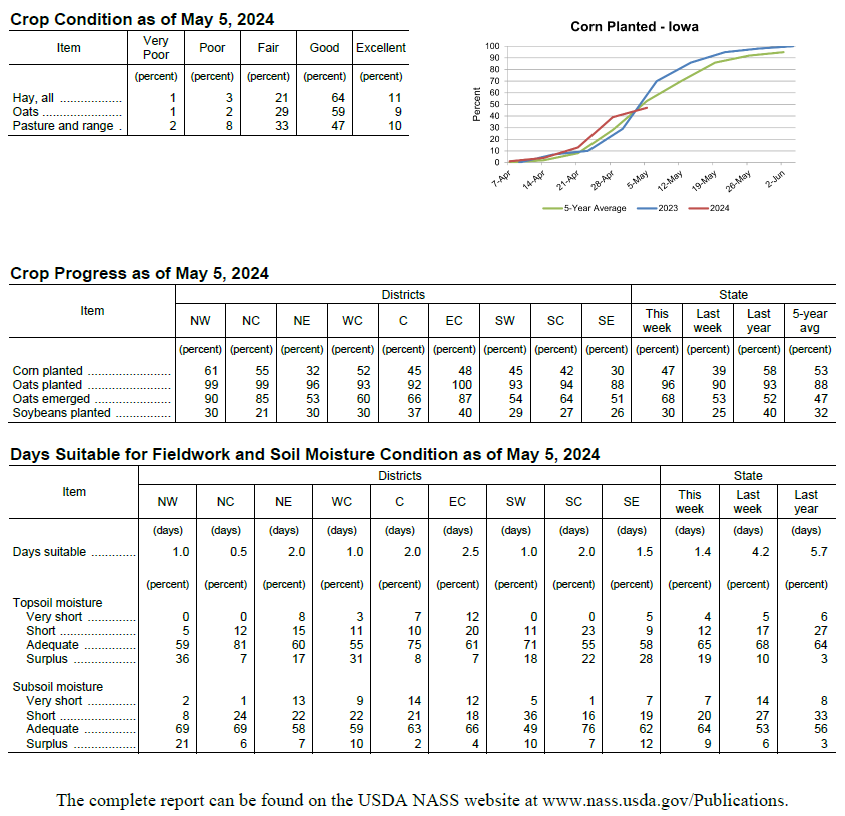
(Des Moines, Iowa)- Fieldwork activities were limited as rain across the State held Iowa farmers to just 1.4 days suitable for fieldwork during the week ending May 5, 2024, according to the USDA, National Agricultural Statistics Service. Rains the past two weeks have resulted in reports of some counties moving out of the extreme to severe drought stages. Topsoil moisture condition rated 4 percent very short, 12 percent short, 65 percent adequate and 19 percent surplus. Subsoil moisture condition rated 7 percent very short, 20 percent short, 64 percent adequate and 9 percent surplus.
Just 8 percent of Iowa’s expected corn crop was planted during the week ending May 5, 2024, for a total of 47 percent planted. This meant progress went from ahead of average to lagging 2 days behind both last year and the 5-year average. Seven percent of the corn crop has emerged, 3 days ahead of last year and 1 day ahead of the average. Soybean planting progress fell behind the previous year with 5 percent of Iowa’s expected soybean crop planted during the week ending May 5, 2024, for a total of 30 percent of the expected soybean crop planted, 2 days behind last year. Four percent of the soybean crop has emerged. Ninety-six percent of the expected oat crop has been planted, 2 days ahead of last year and 10 days ahead of normal. Oat emergence reached 68 percent, 5 days ahead of last year and 1 week ahead of the 5-year average. The first oat condition rating of the season was 1 percent very poor, 2 percent poor, 29 percent fair, 59 percent good and 9 percent excellent.
The first hay condition rating of the season was 1 percent very poor, 3 percent poor, 21 percent fair, 64 percent good and 11 percent excellent. Pasture condition rated 57 percent good to excellent. There were many reports of cattle being turned out to pasture. Unseasonably wet conditions continued through the reporting period with several disturbances crossing the state. Rain on already saturated ground produced flooding in pockets of northern and southeastern Iowa. Temperatures varied from cooler than average in northwestern Iowa to unseasonably warm southeast; the statewide average temperature was near normal at 55.0 degrees.
Showers remained in eastern Iowa with additional redevelopment in western Iowa ahead of a low pressure center through Sunday (28th) afternoon. Daytime temperatures reached into the upper 60s where cloud cover was sparse with light southerly winds. As the low pressure center propagated towards the Great Lakes, winds shifted westerly with Monday (29th) morning lows ranging from the low 40s northwest to upper 50s southeast. Widespread rain totals were reported at 7:00 am with the highest amounts in pockets of northwest and northeast Iowa; Dyersville (Dubuque County) measured 1.01 inches while Storm Lake (Buena Vista County) collected 1.21 inches with a statewide average of 0.35 inches. Overcast skies persisted north through the day with highs in the 50s, while southern Iowa was 10-15 degrees warmer under mostly sunny conditions. Winds became variable after midnight as starry skies reigned ahead of another approaching strong low pressure system.
Initial Tuesday (30th) morning showers fizzled in eastern Iowa as a warm front lifted across southern Iowa, pumping in moisture and increasing atmospheric instability. Discrete supercells fired rapidly along the cold front near the Iowa-Nebraska line around 3:00 pm; these storms tracked east-northeast and became severe-warned almost immediately. Reports of large hail and isolated straight-line winds followed the consolidating line east with 2.00-inch hail in Massena (Cass County) and a weak tornado near Millerton (Wayne County). The cold front exited eastern Iowa overnight into Wednesday (1st) as skies cleared ahead of another weather disturbance to the west. Event rain totals across western Iowa were in the 0.50-0.75-inch range at many stations with lesser amounts farther east. Showers with some rumbles of thunder increased through the late afternoon and evening hours with temperatures in the upper 50s northwest to upper 60s southeast.
Showers and thunderstorms overspread the state into Thursday (2nd) bringing widespread, moderate rainfall to much of Iowa. Rain continued across eastern Iowa through the afternoon hours with stubborn showers holding over the southeast corner where flood warnings were issued. Northwesterly winds ushered in cooler temperatures behind the system as dense fog developed from southwest to north-central Iowa. Rain totals reported on Friday (3rd) morning for the last 36 hours showed almost 200 stations receiving at least the weekly climatological average, which was just shy of an inch. Nearly 30 stations had 2.00 inches or more with 2.10 inches in Sigourney (Keokuk County) to 4.10 inches in Centerville (Appanoose County); the statewide average was 0.98 inches.
Daytime conditions were pleasant with winds gradually shifting southerly and upper 60s and low 70s. Yet another low pressure center entered western Iowa early Saturday (4th) morning with thunderstorms forming a narrow line along the attendant cold front. Rain totals were highest across west-central to north-central Iowa where amounts were in the 0.75-1.00-inch range; many of the state’s remaining stations collected 0.20-0.50 inches. Skies gradually cleared west to east through the afternoon and evening as highs held in the upper 50s. Variable winds developed into Sunday (5th) with lows generally in the upper 30s and low 40s.
Weekly precipitation totals ranged from 0.31 inches at Muscatine (Muscatine County) to 4.53 inches in Forest City (Winnebago County). The statewide weekly average precipitation was 2.23 inches, more than double the normal of 0.93 inches. Shenandoah (Page County) reported the week’s high temperature of 83 degrees on the 30th, 15 degrees above average. Forest City and Storm Lake reported the week’s low temperature of 32 degrees on the 5th, on average 12 degrees below normal. Four-inch soil temperatures ranged from the mid 50s northwest to low 60s southeast as of Sunday.
Temperature and Precipitation Maps, courtesy of the Midwestern Regional Climate Center, are available at: https:/mrcc.purdue.edu/CLIMATE/


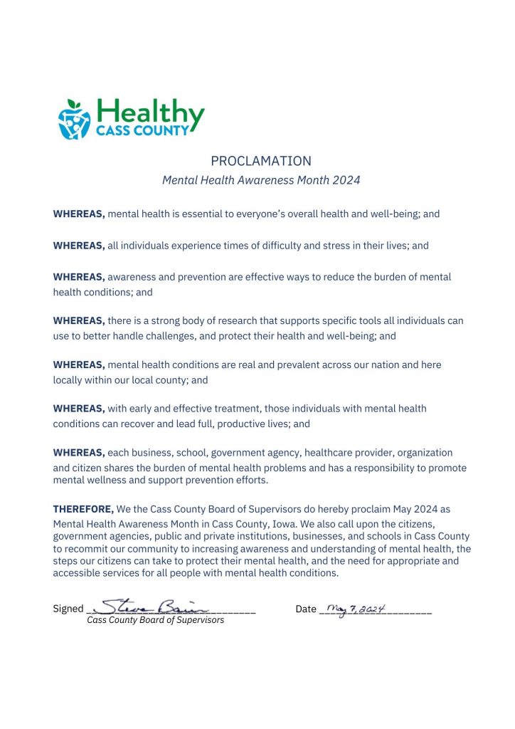
 To help promote Mental Health, the Cass County Coalition for Mental Wellness will host a Mental Wellness Panel on Thursday, May 9, 2024, at the Griswold Community Building (601 2nd Street, Griswold, Iowa 51535). A free meal will be provided at 5:30 pm. The presentation will begin at 6:00 pm. Community members of all ages are welcome to join as we discuss resiliency strategies, emotional support for our youth, and local resources for therapy and crisis situations. No pre-registration is required. This event is sponsored generously by the Healthy Cass County Coalition with funding from the Healthiest State Initiative Grant and Atlantic Coca-Cola Bottling Company. If you have any further questions, please contact Grace McAfee at (712) 250-8170 or